
Mittweida district
| coat of arms | Germany map |
|---|---|

|

Coordinates: 50 ° 59 ′ N , 12 ° 59 ′ E |
| Basic data (as of 2008) | |
| Existing period: | 1994-2008 |
| State : | Saxony |
| Administrative region : | Chemnitz |
| Administrative headquarters : | Mittweida |
| Area : | 773.2 km 2 |
| Residents: | 127,960 (Dec. 31, 2007) |
| Population density : | 165 inhabitants per km 2 |
| License plate : | MW |
| Circle key : | 14 1 82 |
| Circle structure: | 23 municipalities |
| Address of the district administration: |
At the District Office 3 09648 Mittweida |
| District Administrator : | Andreas Schramm ( CDU ) |
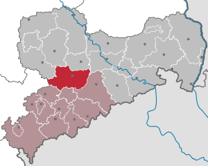
| Location of the Mittweida district in Saxony | |
  |
|
The district of Mittweida was from 1994 to 2008 a district in the western center of the Free State of Saxony . Neighboring districts in the north were the former Muldental district and the district of Döbeln , in the northeast the district of Meißen , in the southeast the former district of Freiberg , in the south the independent city of Chemnitz and the district of Chemnitzer Land and in the west the Thuringian district of Altenburger Land and the district of Leipziger Land .
geography
- Rivers: Zwickauer Mulde , Chemnitz , Zschopau , Große Striegis and Kleine Striegis as well as the Kriebstein dam .
- Mountains: Rochlitzer Berg
See also: List of Landscapes in Saxony , List of Waters in Saxony , Natural Areas in Saxony
economy
- Hochschule Mittweida (FH) - University of Applied Sciences
traffic
- Federal highways: B 7 , B 95 , B 107 , B 169 , B 175 and B 180
- Federal motorway: A 4 , A 72
- Railway routes:
History and territorial structure
The district was created in 1994 on the basis of the first Saxon district reform by amalgamating the districts of Hainichen , Rochlitz (except for three communities) and the northern part of the Chemnitz district as well as three smaller communities from other districts. In 1996, after a referendum from the district of Leipziger Land, the municipality of Obergräfenhain joined the district. The following 48 municipalities formed the new Mittweida district:
- 9 municipalities from the Chemnitz district :
- Auerswalde, Burgstädt, Claußnitz, Hartmannsdorf, Lichtenau, Mohsdorf, Mühlau, Taura b. Burgstädt and Wittgensdorf
- the municipality of Mühlbach from the Flöha district
- the communities of Breitenborn and Langensteinbach from the Geithain district
- 16 municipalities from the Hainichen district :
- Altmittweida, Dittersbach, Frankenberg, Grünlichtenberg, Hainichen, Kriebstein, Krumbach, Lauenhain-Tanneberg, Mittweida, Ottendorf, Reichenbach, Rossau, Schlegel, Schönborn-Dreihaben-Seifersbach, Striegistal and Tiefenbach.
- 20 municipalities from the Rochlitz district :
- Aitzendorf , Arras , Chursdorf , Erlau , Frankenau , Geringswalde , Himmelhartha , Holzhausen , Königsfeld , Königshain-Wiederau , Lunzenau , Milkau, Penig , Rochlitz , Seelitz , Stein i. Chemnitztal , Tauscha , Thierbach , Wechselburg and Zettlitz .
On August 1, 2008, with the district reform of Saxony 2008, a merger into the district of central Saxony with the former districts of Döbeln and Freiberg was implemented.
politics
The last district administrator in the Mittweida district was Andreas Schramm (CDU).
District council
The 58 seats in the last district assembly were distributed among the individual parties as follows:
| Political party | Seats |
| CDU | 29 |
| LEFT | 12 |
| SPD | 9 |
| FDP | 3 |
| Free voters Burgstädt | 3 |
| GREEN | 1 |
| Allotment gardener WVK Taura | 1 |
Group chairmen in the district council:
- Jürgen Kunath - CDU
- Jens Stahlmann - DIE LINKE
- Udo Lindner - SPD
- Joachim Knappe - FDP
- Lothar Naumann - Free voters Burgstädt
cities and communes
(Population figures as of December 31, 2007)
Cities :
|
Municipalities :
|
License Plate
On August 1, 1994, the district was assigned the HC distinguishing mark, which had been valid for the Hainichen district since January 1, 1991, with the letter pairs from XA and the numbers from 1 to 99. This was replaced on January 1, 1995 by the new distinguishing mark MW , which was issued until July 31, 2008. It has been available in the Central Saxony district since November 9, 2012.
Web links
Individual evidence
- ↑ Federal Statistical Office (Ed.): Municipalities 1994 and their changes since 01.01.1948 in the new federal states . Metzler-Poeschel, Stuttgart 1995, ISBN 3-8246-0321-7 .
- ↑ statistik.sachsen.de
Annaberg | Aue-Schwarzenberg | Bautzen | Chemnitz | Chemnitz Land | Delitzsch | Chub | Dresden | Freiberg | Goerlitz | Hoyerswerda | Kamenz | Leipzig | Leipziger Land | Löbau-Zittau | Meissen | Middle Erzgebirgskreis | Mittweida | Muldentalkreis | Lower Silesian Upper Lusatia District | Plauen | Riesa-Großenhain | Saxon Switzerland | Stollberg | Torgau-Oschatz | Vogtlandkreis | Weißeritzkreis | Zwickau | Zwickau country