
Stollberg district
| coat of arms | Germany map |
|---|---|

|

Coordinates: 50 ° 43 ' N , 12 ° 47' E |
| Basic data (as of 2008) | |
| Existing period: | 1990-2008 |
| State : | Saxony |
| Administrative region : | Chemnitz |
| Administrative headquarters : | Stollberg / Erzgeb. |
| Area : | 266.49 km 2 |
| Residents: | 87,237 (Dec 31, 2007) |
| Population density : | 327 inhabitants per km 2 |
| License plate : | STL |
| Circle key : | 14 1 88 |
| Circle structure: | 15 municipalities |
| Address of the district administration: |
Uhlmannstrasse 1–3 09366 Stollberg |
| District Administrator : | Udo Hertwich ( CDU ) |
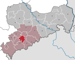
| Location of the Stollberg district in Saxony | |
  |
|
The district of Stollberg was a district in the west of the Free State of Saxony that existed between 1910 and 2008. Neighboring districts were the city of Chemnitz in the northeast, the Middle Ore Mountains District in the east, the Annaberg district in the southwest, the Aue-Schwarzenberg district in the south, the Zwickauer Land district in the west and the Chemnitzer Land district in the northwest .
geography
see also: Natural Areas in Saxony , List of Landscapes in Saxony , List of Waters in Saxony
traffic
Motorway: A 72 - junctions:
- Stollberg-North
- Stollberg-West
Federal highways:
- B 95 ( Burkhardtsdorf )
- B 169 (Neukirchen – Jahnsdorf – Niederdorf – Stollberg)
- B 180 (Burkhardtsdorf – Thalheim – Stollberg – Niederwürschnitz – Lugau)
Train:
- City railway Stollberg– Chemnitz
- Railway line Stollberg– St. Egidien
- Zwönitztalbahn Chemnitz– Aue
history
The Amtshauptmannschaft Stollberg was created in 1910 and renamed the Stollberg district in 1939. In 1950 the district was dissolved for the time being. As early as 1952, however , the Stollberg district was re-established and consisted of the same territorial composition from 1952 to 1994. On August 1 of that year, the city of Zwönitz (until then the district of Aue ) and, from the dissolved district of Chemnitz, the communities of Einsiedel , Kemtau , Burkhardtsdorf , Adorf , Klaffenbach and Neukirchen to the district. In 1997 Einsiedel and Klaffenbach were incorporated into the city of Chemnitz.
In the course of a further administrative reform in Saxony, the districts of Annaberg , Aue-Schwarzenberg , Middle Erzgebirgskreis and Stollberg were merged on August 1st, 2008 to form the new Erzgebirgskreis .
politics
Udo Hertwich was the district administrator of the Stollberg district from 1990 to 2008.
District council
The 49 seats in the district council were distributed among the individual parties as follows in 2008:
Political party |
Seats
|
| CDU |
22nd
|
| FDP / FWU |
10
|
| SPD |
8th
|
| LEFT |
8th
|
| GREEN |
1
|
cities and communes
(Population figures as of December 31, 2006)
|
|
License Plate
At the beginning of 1991 the district received the distinguishing mark STL . It was issued through July 31, 2008. It has been available in the Erzgebirgskreis since November 9, 2012.
Individual evidence
Annaberg | Aue-Schwarzenberg | Bautzen | Chemnitz | Chemnitz Land | Delitzsch | Chub | Dresden | Freiberg | Goerlitz | Hoyerswerda | Kamenz | Leipzig | Leipziger Land | Löbau-Zittau | Meissen | Middle Erzgebirgskreis | Mittweida | Muldentalkreis | Lower Silesian Upper Lusatia District | Plauen | Riesa-Großenhain | Saxon Switzerland | Stollberg | Torgau-Oschatz | Vogtlandkreis | Weißeritzkreis | Zwickau | Zwickau country