
Administrative community Lugau
| coat of arms | Germany map | |
|---|---|---|
 Help on coat of arms |
Coordinates: 50 ° 44 ' N , 12 ° 44' E |
|
| Basic data | ||
| State : | Saxony | |
| County : | Erzgebirgskreis | |
| Area : | 28.33 km 2 | |
| Residents: | 10,584 (Dec. 31, 2019) | |
| Population density : | 374 inhabitants per km 2 | |
| License plate : | ERZ, ANA, ASZ, AU, MAB, MEK, STL, SZB, ZP | |
| Association key : | 14 5 21 5 115 | |
| Association structure: | 2 municipalities | |
| Association administration address : |
Obere Hauptstrasse 26 09385 Lugau |
|
| Administrative Chairman: | Thomas Weikert | |
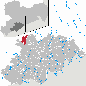
| Location of the administrative community Lugau in the Erzgebirge district | ||
  |
||

The administrative community Lugau is an administrative community in the northwest of the Erzgebirge in the Free State of Saxony . It lies between the B 180 in the west, the B 173 in the north and the A 72 in the east. This can be reached via the connections Stollberg-Nord and Stollberg-West about 8 km. The A 4 running to the north can be reached via the Hohenstein-Ernstthal junction . The community area is about 20 km east of Zwickau , about 18 km west of Chemnitz and about 8 km northwest of the city of Stollberg / Erzgeb. The B 180 runs through the community area. The area lies on the northern edge of the Ore Mountains on the edge of the Ore Mountains Basin .
With the incorporation of Erlbach-Kirchberg into Lugau, a municipality left the administrative community on January 1, 2013.
The municipalities with their districts
- Lugau with the districts Erlbach-Kirchberg and Ursprung
- Niederwürschnitz
Individual evidence