Torgau-Oschatz district
| coat of arms | Germany map |
|---|---|

|

Coordinates: 51 ° 34 ' N , 13 ° 1' E |
| Basic data (as of 2008) | |
| Existing period: | 1994-2008 |
| State : | Saxony |
| Administrative region : | Leipzig |
| Administrative headquarters : | Torgau |
| Area : | 1,167.53 km 2 |
| Residents: | 93,409 (Dec. 31, 2007) |
| Population density : | 80 inhabitants per km 2 |
| License plate : | TO |
| Circle key : | 14 3 89 |
| Circle structure: | 21 municipalities |
| Address of the district administration: |
Schlossstrasse 27 04860 Torgau |
| District Administrator : | Robert Schöpp ( CDU ) |
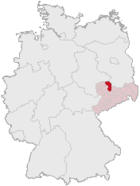
| Location of the Torgau-Oschatz district in Saxony | |
The Torgau-Oschatz district was the northernmost district in the Free State of Saxony . Neighboring districts were the Saxony-Anhalt district of Wittenberg in the north, the Brandenburg district of Elbe-Elster and the district of Riesa-Großenhain in the east, the district of Döbeln in the south and the Muldental district and the district of Delitzsch in the west .
history
The district was created in 1994 by merging the districts of Oschatz and Torgau as well as six communities of the former district of Eilenburg . After the district reform of Saxony in 2008 on August 1, 2008, the district was dissolved and its area has been part of the new district of Northern Saxony since then .
heraldry
The lion depicted on the coat of arms is the Meissen lion, which can be found in the coat of arms of many communities in the area due to the earlier territorial affiliations. The branch (a linden branch ) that the lion is holding in its claws is a symbol of agriculture and the forestation of the Elbe landscape in the area, which is why the stylized river in the lower area of the coat of arms should also embody the Elbe . The yellow or gold background often found in Saxon refers to the Ascanian dukes.
cities and communes
(Population figures as of December 31, 2006)
|
|
Between 1990 and 2004, the average age in the district rose from 37 to 43 years.
Damit war Torgau-Oschatz aber immer noch einer der „jüngsten“ Landkreise in Sachsen und lag deutlich unter dem Landesdurchschnitt.
traffic
As early as 1838, the Leipzig-Dresdner Eisenbahn-Compagnie opened the section that touches the city of Oschatz and thus today's district.
The city of Torgau was not connected to the rail network until 1872 by the Halle-Sorau-Gubener Railway Company . A small railway junction was created here when the Prussian State Railway opened a branch line, the Dübener-Heide-Bahn , to Pretzsch (in the direction of Wittenberg) in 1890 and a branch line to Belgern in 1914/15 ( Torgau – Belgern line ). Another junction from the Cottbus - Leipzig line was created in 1922 by the Kleinbahn AG Schildau – Mockrehna .
A narrow-gauge network operated by the Saxon State Railways was built in the Oschatz area from 1885, the center of which was Mügeln with the largest narrow-gauge railway station in Europe at the time:
- 1884 Döbeln - Mügeln
- 1885 Mügeln - Oschatz
- 1888 Mügeln - Nebitzschen - Neicha-Zöhda
- 1891 Oschatz - Strehla
- 1903 Nebitzschen - Kemmlitz - Kroptewitz
A section of this network has been operated by Döllnitzbahn GmbH between Oschatz and Kemmlitz since 1993.
The network had a circumference of 135 km. Of these, 70 km were shut down:
- 1964: Kemmlitz - Kroptewitz = 750 = 1 km and Döbeln Hbf - Lüttnitz - Mügeln = 750 = 4 km
- 1971: Gneisenaustadt Schildau - Mockrehna 11 km
- 1972: Nebitzschen - Wermsdorf - Neichen-Zöhda = 750 = 10 km and Oschatz - Zaußwitz - Strehla (ex = 750 =) 9 km
- 1997: Torgau - Wörblitz - Pretzsch 18 km
- 1995: Torgau - Belgern 17 km
License Plate
On August 1, 1994, the district was assigned the TG , which has been valid since January 1, 1991 for the Torgau district. This was replaced on January 1, 1995 by the new distinctive sign TO , which was issued until July 31, 2008. Due to the license plate liberalization , both have been available in the northern Saxony district since November 9, 2012 .
Until about the year 2000 vehicles from the old district of Oschatz received TO license plates with the letters AA to ZZ and the numbers from 100 to 999.
literature
- Matthias Donath: Leipziger Land. Cultural Landscapes of Saxony Vol. 2 , Edition Leipzig, Leipzig 2010
- Martin Kühn: 25 years of Schützenkres 9 Torgau-Oschatz 1993–2018. Norderstedt 2018.

