Liebschützberg
| coat of arms | Germany map | |
|---|---|---|
 Help on coat of arms |
Coordinates: 51 ° 21 ' N , 13 ° 8' E |
|
| Basic data | ||
| State : | Saxony | |
| County : | North Saxony | |
| Height : | 140 m above sea level NHN | |
| Area : | 68.67 km 2 | |
| Residents: | 2975 (Dec. 31, 2019) | |
| Population density : | 43 inhabitants per km 2 | |
| Postal code : | 04758 | |
| Area code : | 03435 | |
| License plate : | TDO, DZ, EB, OZ, TG, TO | |
| Community key : | 14 7 30 170 | |
| LOCODE : | DE LB7 | |
| Community structure: | 17 localities | |
| Address of the municipal administration: |
Straße der Jugend 5 04758 Liebschützberg OT Borna |
|
| Website : | ||
| Mayor : | David Schmidt ( CDU ) | |
| Location of the community of Liebschützberg in the northern Saxony district | ||
Liebschützberg is a municipality in the district of North Saxony in the Free State of Saxony .
Geography and traffic
The community is located in the lowland of the Döllnitz west of the Elbe and south of the Dahlener Heide . The neighboring towns are Oschatz (5 km), Dahlen (15 km) and Riesa (15 km). The federal highway 6 runs south and the federal highway 182 east of the municipality. The B 6 and the Dresden-Leipzig railway line can be reached via Oschatz.
Community structure
history
The area around Liebschützberg was settled as early as the Neolithic Age, as evidenced by some finds in the area. After the Great Migration , around the 6th century, the Slavic Daleminzians settled here. The individual districts of the municipality are therefore mostly of Slavic origin. In order to defend their settlements, they built moated castles in the swampy lowlands of the Döllnitz near Canitz and Borna.
The East Franconian King Heinrich I defeated them in 927 and 929 and brought the first Franconian settlers into the country. The area was then subordinated to the Margrave of Meissen . The place Borna is mentioned for the first time on August 2, 1185 in a document from Margrave Otto von Meißen . In the 13th century there were several major famines and from the 14th century plague epidemics also occurred here. In the 15th century the Hussite Wars wreaked havoc in the area around Oschatz and the Thirty Years' War also claimed some victims, so the castle in Borna was completely destroyed. In the Middle Ages, the trade route leading from Halle via Dresden to Poland, the "Hohe Strasse" (old salt route), was of major importance for the area.
When the community was reformed on January 1, 1994, the communities of Gaunitz, Wellerswalde (with Leisnitz) and Laas (with Klötitz, Leckwitz and Sahlassan) merged to form the community of Liebschützberg. On January 1, 1997, the Borna community was added.
Memorials
In the cemetery of the district of Ganzig there is a grave site for ten Polish and Ukrainian forced laborers who were deported to Germany during the Second World War and shot on April 30, 1945 by soldiers of a Wehrmacht unit in the village.
Population development
Development of the population (December 31):
|
|
|
Data source from 1990: State Statistical Office of the Free State of Saxony 1 October 3
politics
Municipal council
Since the municipal council election on May 26, 2019 , the 16 seats of the municipal council have been distributed among the individual groups as follows:
Partner municipality
- Gailingen am Hochrhein (Baden-Württemberg)
Attractions
→ see also: List of cultural monuments in Liebschützberg
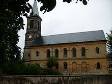
- Borna village church
- Borna Castle, rebuilt in historicism style in 1877
- Liebschützer mountain range with post mill
- Zaußwitz tower windmill, from 1799
- Church of Ganzig
Personalities
- Carl Gottlob Abela (1803–1841), musician
- Wilhelm Kopp (1882–1963), rear admiral in World War II, born in what is now the Wellerswalde district
literature
- Hartmut Conrad: Families in Ganzig (North Saxony district) 1543 to 1800. Leipzig: Working group for Central German family research 2011 (= Central German local family books of the AMF 61)
Web links
- Liebschützberg in the Digital Historical Directory of Saxony
- Website of the community of Liebschützberg
- Wellerswalde district
- Borna Castle
Individual evidence
- ↑ Population of the Free State of Saxony by municipalities on December 31, 2019 ( help on this ).
- ↑ Municipalities 1994 and their changes since January 1, 1948 in the new federal states , Metzler-Poeschel publishing house, Stuttgart, 1995, ISBN 3-8246-0321-7 , publisher: Federal Statistical Office
- ^ StBA: Changes in the municipalities, see 1997
- ↑ Results of the 2014 municipal council elections


