
Cavertitz
| coat of arms | Germany map | |
|---|---|---|
 Help on coat of arms |
Coordinates: 51 ° 23 ' N , 13 ° 8' E |
|
| Basic data | ||
| State : | Saxony | |
| County : | North Saxony | |
| Height : | 103 m above sea level NHN | |
| Area : | 69.16 km 2 | |
| Residents: | 2214 (Dec. 31, 2019) | |
| Population density : | 32 inhabitants per km 2 | |
| Postal code : | 04758 | |
| Area code : | 034363 | |
| License plate : | TDO, DZ, EB, OZ, TG, TO | |
| Community key : | 14 7 30 050 | |
| LOCODE : | DE CVR | |
| Community structure: | 12 districts | |
| Address of the municipal administration: |
Friedensstrasse 4, 04758 Schöna 04758 Cavertitz |
|
| Website : | ||
| Mayoress : | Christiane Gürth (independent) | |
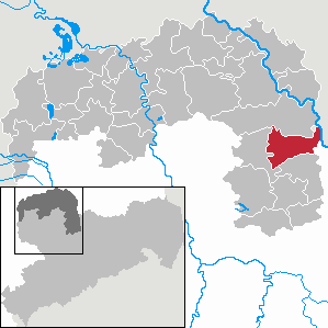
| Location of the municipality Cavertitz in the district of North Saxony | ||
  |
||


Cavertitz is a municipality in the district of North Saxony , Saxony . The administrative headquarters are located in the Schöna district, to which it was relocated from Cavertitz in 2005.
Geography and traffic
The municipality of Cavertitz is located in the north of the Free State of Saxony. In the far east the community borders the Brandenburg town of Mühlberg / Elbe , from the north it is bounded by the town of Belgern-Schildau , in the south by the community of Liebschützberg and in the west by the town of Dahlen . The community is roughly halfway between the two cities of Dresden and Leipzig , which can be easily reached via the traffic routes mentioned below.
Cavertitz is located on the eastern and southern edges of the Dahlener Heide , in the Dahleaue with its large meadows and pastures. The neighboring towns are Strehla (8 km), Oschatz (9 km) and Dahlen (9 km). The federal highway 182 runs through the west of the municipality and the federal highway 6 runs south of the municipality. The international Elbe cycle path leads through the east of the municipality . The community is traversed by the Dahle , as well as many smaller streams, such as the Tauschke or the Schönaer Bach. In the extreme northeast of the municipality, the Elbe forms the municipal and state border with Brandenburg for a short distance.
Districts
The districts of the municipality are:
History and districts
The current municipality of Cavertitz was newly formed on March 1, 1994 from the previous municipalities of Bucha, Cavertitz, Schirmeitz and Sörnewitz.
- Cavertitz
Cavertitz is on the edge of the Dahlener Heide in the Dahleaue . The origin of the name is unclear. It is assumed, however, that it comes from the Slavic Korrot , which translated means something like door post or fountain handle . Around 900 the Burgward von Cavertitz was built in the course of the German settlement in the east . In 1240 Odo and Bodo von Ilburg donated the knightly seat to the Güldenstern monastery in Mühlberg . This was the first written mention of the place. After the secularization of the monastery in the 16th century, the village came into the possession of the Saxon electors. During the Thirty Years' War Cavertitz was burned down by Swedish troops under General Johan Banér in 1636 . In 1760, during the Seven Years' War herbergte Frederick the Great one night in the Electoral Castle to Cavertitz. From 1815 to 1818 the village belonged to Prussia, but after a long effort by the villagers it came back to the Kingdom of Saxony. After the Second World War , the castle of the manor Bramsch, like many others, was to be blown up. However, this was prevented by the use of the Russian officer Konkow and some teachers. The palace was converted into a school and was inaugurated as the first central school in Saxony on September 25, 1946.
- Umbrella seat
The place is an old settlement near an Elbe ford. Germanic peoples lived here as early as 500 BC, after which Slavs immigrated, as shown by grave finds from the 9th, 11th and 12th centuries. First mention of Schirmeitz: 1113 to the diocese of Naumburg, 1130 as a place in the castle area Treskowa (Döschkau) / King Heinrich I defeated the Wends in 931 near Großenhain. The church dates from the time before the Reformation , as well as the "old parsonage" in which Emperor Charles V stayed with Pastor Umlauf when the " Battle of Mühlberg " took place in 1547. Then the Saxon-Wittenberg elector Johann Friedrich was defeated by the emperor. The Spaniards camped on the "Spensberg" (Spanierberg) 400 m from here on the B 182 to Außenig. In 1638, during the Thirty Years' War, the imperial headquarters were in town. The former community went on March 1, 1994 in the new community Cavertitz.
- Reudnitz
In 1253 Reudnitz was first mentioned as Rudenicz . Translated from Slavic, the name means place where lawn iron ore is located. During the Thirty Years' War Reudnitz was completely destroyed and not rebuilt. Only the former monastery was spared and served as a hospital during the war. The homestead formed the basis for a forest estate mentioned in 1791. In 1815 Reudnitz was briefly part of Prussia. After an exchange of territory in 1818, the settlement finally belonged back to Saxony. After 1945 the forest estate belonged to the Cavertitz estate. The Heideverein is located in Reudnitz.
- Olganitz
Olganitz is located about 3 km northeast of Cavertitz, on the southeast edge of the Dahlener Heide. The village was first mentioned in 1242 as Dolganewiz . In 1559 Olganitz belonged to the Mühlberg monastery. In the 16th century it came to the Wurzen office and finally to the Oschatz office in 1815. In the 19th century, the local clay pit supplied the potters in Strehla and Oschatz. After the last war, many refugees came to Olganitz. The place was incorporated into Sörnewitz on January 1, 1969.
- Nice
Schöna is about 2.6 km west of Cavertitz. The first mention of the village took place in 1314 with the name Schonov over Schönaw up to 1748 zu Schöna . In the past centuries, vines were planted on the northern edge of the village, on the vineyard. However, they were badly affected by the Thirty Years' War. Through the Congress of Vienna in 1815 Schöna came to Prussia and through the exchange of territory in 1818 back to Saxony.
- Outside
Outside is directly on the federal highway 182. It is located approx. 4.5 km northeast of Cavertitz. There is the outdoor beaver reserve with softwood alluvial forest, swamp forest and near-natural flat landscape. The 2002 flood caused severe devastation in Außenig, which is in the immediate vicinity of the Elbe. The place was incorporated into Schirmeitz on July 1, 1950.
- Bucha
It was first mentioned in 1285 as “book”, which means something like the book or beech forest. Bucha became common from 1696. There used to be an old Sorbian defense system on the Kirchberg. In addition, one can find a group of burial mounds from the Bronze Age called “War Goods” in Bucha. In 1520 Bucha belonged to the Wellerswalde manor, to which the parish church and school were also subordinate. The inhabitants made their living from agriculture, viticulture and working in the blacksmith and water mill. During the GDR era, Bucha developed into a holiday resort. The place went on March 1, 1994 in the new municipality Cavertitz.
This district was first mentioned in a document in 1221. The place was incorporated on January 1, 1998.
- Zeuckritz
Zeuckritz was first mentioned in a document in 1260 as Zukaritz , who founded the name after Slavic settlers. It belonged to the Lampertswalde manor and was owned by the Pflugk family for a long time. Zeuckritz was completely destroyed during the Thirty Years War. Around 1554 a sheep farm was assigned to Zeuckritz, which in 1800 was one of the largest in Saxony. In 1895 almost all the houses on the main street burned down. After the Second World War, many refugees found shelter in the small village. The population rose from 162 to 231 people. Zeuckritz was incorporated into Bucha on July 1, 1950.
- Soernewitz
Sörnewitz is located approx. 2.5 km southwest of Cavertitz. The place is in the Dahleaue directly on the Dahle. In the past the village consisted of two independent villages, Sörnewitz (left of the Dahle) and Möhla (right of the Dahle). Sörnewitz belonged to the Mühlberg monastery, Möhla was a Bohemian fiefdom. In 1396 the provost of the Mühlberg monastery transferred the village of Sörnewitz, which Christoph von Maltitz had abandoned to Cavertitz and sold to the Buch monastery . Since it was a matter of spiritual property, the Bishop of Meissen also had to agree. At the same time, Christoph von Maltitz sold the village of Möhla to the monastery on Cavertitz after he had given it up to the King of Bohemia. The purchase price was "637 shock of a good new Groschen Freiberg coin". The following are named as witnesses: "Her Niclaus von Mirowe, pastor of Sernuwicz, Johannes and Heinrich brothers of kokricz, sat czu Sabelticz, Dyterich von körbicz, gesessin czu Olczk, Albrecht von Berndorf, Poppe von kökricz, Gunter von czettras, herman von czettras, frenzil judge czu Sernuwicz, hannus bertram there ”. This was followed by confirmation for Soernewitz by Mgf. Wilhelm and the transfer of both courts, the transfer of Möhla by Kg. Wenzel and the insurance of the gewere with the names of the sources "Ortil von Kanewicz, Heinrich Gans and Fredeman von Hugewicz". In 1553 both places belonged to the Torgau office. The former community lost its independence and has belonged to Cavertitz since March 1, 1994.
- Treptitz
Treptitz is located approx. 2 km north of Cavertitz in the middle of the conservation area of the stream of the "Tauschke". The area of the Tauschke is a particularly attractive, hilly, forest and meadow rich landscape, in which over 20 endangered plant species occur. Treptitz was incorporated into Cavertitz on July 1, 1973.
politics
Since the municipal council election on May 25, 2014 , the 18 seats of the city council have been distributed among the individual groups as follows:
- CDU : 7 seats
- SPD : 3 seats
- Association for ecological water protection Treptitz e. V. (VÖG): 3 seats
- FDP : 1 seat
Attractions


- Post mill in Zeuckritz
- Nature reserve "Hospitalberge and Reudnitz"
- Lampertswalde Castle Park
- Romanesque village church from 1396 in Olganitz
- Landscape protection area of the Tauschke stream
- Rectory in Schirmeitz; Emperor Charles V and his brother Ferdinand , King of Bohemia and Hungary stayed here in 1547 during the Battle of Mühlberg .
- Church in Schirmeitz from the 12th century. The new baroque rectory (half-timbered building) was attached to the old rectory in 1728. The Gothic church with the valuable roof structure (around 1560) is baroque inside. The tower is atypically in the east.
- Three-arch bridge made of field stones over the Dahle from 1845 in Klingenhain
- Village church from the 12th or 13th century in Sörnewitz
- important sights in Cavertitz:
- Romanesque village church
- Castle of the manor (today's school)
- Manor from the 13th century in Cavertitz
- Atonement cross from the Middle Ages at the exit to Laas
- Dreiseitenhöfe in the village center (especially on the main road)
- Burgelsberg, the Biesenteich, the Pfarrwäldchen, the Cavertitzer Berg and the Burschenberg (popularly called Bummiberg)
- Stork's nest on the roof of the estate in Cavertitz
Culture
The Nachtdigital festival takes place annually in the Olganitz district on the grounds of the school campus .
schools

- Cavertitz Primary School
In 1946 the school was the first central school in Saxony. From October 7, 1974 (25th anniversary of the GDR) to 1990 it was called the Fritz Weineck Polytechnic High School . From 1990 to 2003 it was a combined middle school and elementary school in Cavertitz and has been elementary school in Cavertitz since 2003.
Fire brigades
There are seven volunteer fire brigades in the community of Cavertitz .
Personalities
- Christian Friedrich Exner (born May 13, 1718 in Lampertswalde, † 1798 in Dresden), architect, Saxon master builder and professor at the Dresden Art Academy .
literature
- Cornelius Gurlitt : Cavertitz. In: Descriptive representation of the older architectural and art monuments of the Kingdom of Saxony. 27. Booklet: Oschatz Official Authority (Part I) . CC Meinhold, Dresden 1905, p. 68.
Individual evidence
- ↑ Population of the Free State of Saxony by municipalities on December 31, 2019 ( help on this ).
- ↑ Church history Bucha ( Memento of the original from June 27, 2015 in the Internet Archive ) Info: The archive link was inserted automatically and has not yet been checked. Please check the original and archive link according to the instructions and then remove this notice. at the Evangelical Parish Schmannewitz-Bucha
- ↑ a b c d e f g h municipalities 1994 and their changes since 01.01.1948 in the new federal states , Metzler-Poeschel publishing house, Stuttgart, 1995, ISBN 3-8246-0321-7 , publisher: Federal Statistical Office
- ^ StBA: Changes in the municipalities in Germany, see 1998
- ↑ Original certificate SHStA Dresden: 10001, older documents, No. 4941. Printed by Schöttgen , Codex Diplomaticus Monasterii book, as No. 221.
- ↑ Original certificate SHStA Dresden: 10001, older documents, No. 4944. Printed by Schöttgen , Codex Diplomaticus Monasterii book, as No. 222.
- ^ Printed by Schöttgen , Codex Diplomaticus Monasterii Buch, as nos. 223 to 226.
- ↑ Results of the 2014 municipal council elections
Web links
- Cavertitz in the Digital Historical Directory of Saxony
- Outsig district
- Cavertitz community

Arzberg | Bad Düben | Beilrode | Belgern-Schildau | Cavertitz | Dahlen | Delitzsch | Doberschütz | Dommitzsch | Dreiheide | Eilenburg | Elsnig | Jesewitz | Krostitz | Lousy | Liebschützberg | Löbnitz | Mockrehna | Mucking | Naundorf | Oschatz | Rackwitz | Schkeuditz | Schönwölkau | Taucha | Torgau | Trossin | Wermsdorf | Wiedemar | Zschepplin