
Aue-Schwarzenberg district
| coat of arms | Germany map |
|---|---|

|

Coordinates: 50 ° 35 ' N , 12 ° 42' E |
| Basic data (as of 2008) | |
| Existing period: | 1994-2008 |
| State : | Saxony |
| Administrative region : | Chemnitz |
| Administrative headquarters : | Aue |
| Area : | 528.33 km 2 |
| Residents: | 127,229 (Dec. 31, 2007) |
| Population density : | 241 inhabitants per km 2 |
| License plate : | ASZ |
| Circle key : | 14 1 91 |
| Circle structure: | 17 municipalities |
| District Administrator : | Karl Matko ( CDU ) |
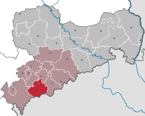
| Location of the Aue-Schwarzenberg district in Saxony | |
  |
|
The district of Aue-Schwarzenberg ( Westerzgebirgskreis until 1995 ) was a district in the southwest of the Free State of Saxony . Since 2008 it has formed the western part of the newly created Erzgebirgskreis .
geography
The district of Aue-Schwarzenberg was in the west of the Saxon Ore Mountains. Its highest point was the 1019 m high Auersberg between Eibenstock and Johanngeorgenstadt. The largest river was the Zwickauer Mulde , which flowed through the district from south to north, passing through the town of Aue. The neighboring districts were in the north the district of Zwickauer Land and the district of Stollberg , in the east the district Annaberg , in the south the Czech administrative district Karlsbad ( Karlovarský kraj ) and in the west the Vogtlandkreis .
economy
The district called itself the “cradle of metal forming” and was represented by a number of medium-sized companies in the metalworking industry. The region has been involved in tourism since the first half of the 20th century and attracted numerous visitors, especially in the winter months.
history
A large part of the municipalities in the district owed its existence to the gradual settlement of the Ore Mountains, which began in the second half of the 12th century. The cities of Schneeberg and Johanngeorgenstadt, on the other hand, are much younger. One emerged, like some of its neighboring communities, as a result of the emergence of mining, the other as a settlement of exiles from neighboring Bohemia.
After the Second World War in 1945, some cities and towns were not occupied by either the Soviet or American occupation forces for a few weeks (see “ Free Republic of Schwarzenberg ”).
The district was created as a result of the district reform on August 1, 1994 by merging the districts of Aue and Schwarzenberg . It was initially called the Westerzgebirgskreis and was renamed the Aue-Schwarzenberg district on January 1, 1995.
In the course of another administrative reform in Saxony, the districts of Annaberg , Aue-Schwarzenberg, Middle Erzgebirgskreis and Stollberg merged on August 1st, 2008 to form the Erzgebirgskreis .
politics
District Administrator
The district administrator of the Aue-Schwarzenberg district was Karl Matko (CDU) throughout .
District council
The 58 seats in the last district assembly (2004–2008) were distributed among the individual parties as follows:
Political party |
Seats
|
| CDU |
30th
|
| LEFT |
11
|
| FWV |
7th
|
| SPD |
5
|
| FDP |
3
|
| DSU |
1
|
| GREEN |
1
|
Partnerships
The Aue-Schwarzenberg district had the following partnerships:
- District of Ansbach , Bavaria (since 1990)
- District Neustadt an der Aisch-Bad Windsheim , Bavaria (since 1990)
- Regional municipality of Karlovy Vary , Czech Republic (since 1991)
cities and communes
(Population figures as of December 31, 2006)
|
|
- Administrative community Eibenstock with the member communities Stadt Eibenstock and Sosa
- Administrative community Zschorlau with the member communities Bockau and Zschorlau
License Plate
On August 1, 1994, the district was assigned the AU distinguishing mark , which has been valid for the Aue district since January 1, 1991 . It was replaced on January 1, 1995 by the new distinguishing mark ASZ . This was issued until July 31, 2008. It has been available in the Erzgebirgskreis since November 9, 2012 due to the license plate liberalization .
Until about the year 2000 vehicles from the old district of Schwarzenberg received ASZ license plates with the letters A to Z and the numbers from 1 to 999.
Individual evidence
- ↑ http://www.statistik.sachsen.de/wpr_alt/pkg_w04_erg_kt.prc_erg_kt?p_bz_bzid=KT04&p_ebene=LK&p_ort=14191
Web links
Annaberg | Aue-Schwarzenberg | Bautzen | Chemnitz | Chemnitz Land | Delitzsch | Chub | Dresden | Freiberg | Goerlitz | Hoyerswerda | Kamenz | Leipzig | Leipziger Land | Löbau-Zittau | Meissen | Middle Erzgebirgskreis | Mittweida | Muldentalkreis | Lower Silesian Upper Lusatia District | Plauen | Riesa-Großenhain | Saxon Switzerland | Stollberg | Torgau-Oschatz | Vogtlandkreis | Weißeritzkreis | Zwickau | Zwickau country