
Aue district
| Basic data | |
|---|---|
| District : | Karl Marx City |
| Administrative headquarters : | Aue |
| Area : | 365 km² |
| Residents: | 116,242 (1989) |
| Population density: | 318 inhabitants per km² |
| License plate : | T, X (1953–1990) TB, XB (1974–1990) AU (1991–1994) |
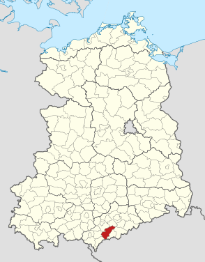
| Location of the district in the GDR | |
  |
|
The Aue district was a district in the Karl-Marx-Stadt district of the GDR . From 1990 to 1994 it existed as the Aue district in the Free State of Saxony . His area is now in the Erzgebirge in Saxony. The seat of the district administration was in Aue .
geography
location
The district of Aue was in the western Ore Mountains on the border with Czechoslovakia .
Neighboring areas
The Aue district bordered clockwise in the southwest, starting with the districts of Klingenthal , Auerbach , Zwickau-Land , Stollberg , Annaberg and Schwarzenberg . In the south it bordered on Czechoslovakia .
history


In 1874, the Schwarzenberg district administration was formed in the Kingdom of Saxony as part of a comprehensive administrative reform . In 1947, as their successor in the state of Saxony in the Soviet occupation zone, the district of Schwarzenberg was renamed the Aue district. On July 1, 1950, the Stollberg district was dissolved. The city of Zwönitz and four communities in this district (Beutha, Gablenz, Lenkersdorf and Oberdorf) came to the Aue district. On December 17, 1951, the towns of Johanngeorgenstadt and Schneeberg were spun off as urban districts from the district. At the same time, the new districts of Aue (21 communities) and Schwarzenberg (15 communities) were formed from the remaining district area.
The " Law on the further democratization of the structure and functioning of the state organs in the state of Saxony " passed by the Saxon state parliament on July 25, 1952 came into force on the same day. The following 22 communities now formed the (new) district of Aue: Affalter, Albernau, Aue, Bernsbach, Blauenthal, Bockau, Burkhardtsgrün, Carlsfeld, Dittersdorf, Eibenstock, Grüna, Hundshübel, Grünheide, Lauter, Lößnitz, Schönheide, Sosa, Stützengrün, Wildenthal , Zschorlau, Zwönitz and Lichtenau from the Zwickau district . The district was assigned to the Karl-Marx-Stadt district, the district seat was Aue.
After almost seven years, Schneeberg lost its district freedom and on November 23, 1958 it was reintegrated into the Aue district.
Up until the disbandment of the district in 1994, the following municipal area changes and reclassifications occurred:
- December 17, 1951 - Incorporation of Steinbach into the town of Johanngeorgenstadt, which is spun off from the Aue district as the Johanngeorgenstadt district
- December 17, 1951 - Incorporation of Griesbach, Lindenau, Radiumbad Oberschlema and Niederschlema into the town of Schneeberg, which is spun off from the Aue district as the town district of Schneeberg
- April 1, 1952 - Beutha, Gablenz and Oberdorf move back to the re-established Stollberg district
- April 01, 1952 - Incorporation of Lenkersdorf into the city of Zwönitz
- December 4, 1952 - Lichtenau moves back to the Zwickau district
- December 4, 1952 - Wildbach changes from the Zwickau district to the Aue district
- November 23, 1958 - Dissolution of the city district of Schneeberg and reintegration of the city of Schneeberg into the district of Aue
- November 23, 1958 - Formation of Schlema from Nieder- and Oberschlema, after being separated from the city of Schneeberg
- Nov. 23, 1958 - Lindenau is outsourced from the town of Schneeberg
- August 5, 1962 - The municipality of Lauter / Sa. receives city rights
- 1971 - Carolagrün is spun off as a district of Schönheide into the Auerbach district
- February 1, 1974 - Incorporation of Dittersdorf into the city of Loessnitz
- February 1, 1974 - Grüna incorporated into Affalter
- January 1, 1994 - Incorporation of Wildbach in Schlema
- January 1, 1994 - incorporation of Blauenthal and Wildenthal into the town of Eibenstock
On May 17, 1990, the district was renamed the Aue district. On the occasion of the reunification of the two German states, the district was awarded to the re-established state of Saxony in October 1990. During the first Saxon district reform on August 1, 1994, it was almost completely absorbed into the new Westerzgebirgskreis district, which was renamed the Aue-Schwarzenberg district in 1995 . The city of Zwönitz moved to its "old" district of Stollberg, to which it had belonged until June 1950.
Population development
| Aue district | ||||||||
|---|---|---|---|---|---|---|---|---|
| year | 1960 | 1971 | 1981 | 1989 | ||||
| Residents | 140.352 | 134,733 | 123.824 | 116,242 | ||||
economy
The economy in the district was dominated by uranium mining by the Soviet-German stock corporation Wismut with the large mining company Schneeberg / Schlema / Alberoda .
Other important companies included:
- VEB Nickelhütte Aue
- VEB cutlery and metal goods Aue
- VEB Textima Aue
- VEB Spielwarenwerke Schneeberg
- VEB measuring device factory Zwönitz
traffic
The F 93 from Schneeberg to Zwickau , the F 101 from Aue to Annaberg-Buchholz , the F 169 from Plauen via Aue to Karl-Marx-Stadt and the F 283 from Aue to Klingenthal served national road traffic .
The district area was opened up by the Chemnitz – Aue – Adorf and Zwickau – Aue – Schwarzenberg railway lines.
Population data
Population overview of all 23 communities in the district that came to the re-established state of Saxony in 1990.
| AGS | local community | Residents | Area (ha) | |
| 3rd October 1990 | December 31, 1990 | |||
| 14012010 | Affalter | 1 488 | 1 480 | 1 106 |
| 14012020 | Albernau | 1 251 | 1 247 | 256 |
| 14012030 | Aue, city | 24765 | 24447 | 2099 |
| 14012040 | Bernsbach | 4 251 | 4,220 | 875 |
| 14012050 | Blauenthal | 303 | 306 | 360 |
| 14012060 | Bockau | 3 125 | 3 112 | 1 915 |
| 14012070 | Burkhardtsgrün | 347 | 349 | 305 |
| 14012080 | Carlsfeld | 1 119 | 1 106 | 2,418 |
| 14012100 | Eibenstock , city | 6 365 | 6 277 | 4,077 |
| 14012120 | Hundshübel | 1 310 | 1 306 | 1 163 |
| 14012130 | Louder / Sa. , City | 5699 | 5589 | 2154 |
| 14012140 | Lichtenau | 440 | 434 | 624 |
| 14012150 | Lindenau | 663 | 667 | 514 |
| 14012160 | Lößnitz, city | 10589 | 10790 | 1949 |
| 14012170 | Schlema | 5 504 | 5 431 | 880 |
| 14012180 | Schneeberg, city | 20 446 | 20 303 | 1 921 |
| 14012190 | Schönheide | 6 347 | 6 301 | 2 809 |
| 14012200 | Sosa | 2,444 | 2,438 | 2 199 |
| 14012210 | Column green | 2,467 | 2 451 | 1 050 |
| 14012220 | Torrent | 595 | 590 | 568 |
| 14012230 | Wildenthal | 320 | 322 | 2 180 |
| 14012240 | Zschorlau | 4 121 | 4 098 | 1 639 |
| 14012250 | Zwönitz , city | 10 180 | 10 084 | 3 413 |
| 14012 | Aue district | 114 139 | 113 348 | 36 474 |
License Plate
Motor vehicles (with the exception of motorcycles) and trailers were assigned three-letter distinctive signs starting with the letter pairs TB and XB from around 1974 to the end of 1990 . The last number plate series used for motorcycles was XW 00-01 to XW 50-00 .
At the beginning of 1991 the district received the distinguishing mark AU . It was issued until December 31, 1994. It has been available in the Erzgebirgskreis since November 9, 2012 .
Individual evidence
- ↑ a b Law on the self-administration of municipalities and districts in the GDR (municipal constitution) of May 17, 1990
- ↑ a b Federal Statistical Office (ed.): Municipalities 1994 and their changes since 01.01.1948 in the new federal states . Metzler-Poeschel, Stuttgart 1995, ISBN 3-8246-0321-7 .
- ^ The eastern Vogtland (= values of the German homeland . Volume 59). 1st edition. Verlag Hermann Böhlaus Successor, Weimar 1998, ISBN 3-7400-0938-1 , p. 163.
- ^ Statistical yearbooks of the German Democratic Republic. In: DigiZeitschriften. Retrieved October 6, 2009 .
- ↑ Saxony regional register
- ↑ Andreas Herzfeld: The history of the German license plate . 4th edition. German Flag Society V., Berlin 2010, ISBN 978-3-935131-11-7 , pp. 303 .
- ↑ Andreas Herzfeld: The history of the German license plate . 4th edition. German Flag Society V., Berlin 2010, ISBN 978-3-935131-11-7 , pp. 526 .