
Brand-Erbisdorf district
| Basic data | |
|---|---|
| District : | Karl Marx City |
| Administrative headquarters : | Brand-Erbisdorf |
| Area : | 353.73 km² |
| Residents: | 35,563 (Oct 3, 1990) |
| Population density: | 101 inhabitants per km² |
| Circle structure: | 22 municipalities , 3 cities |
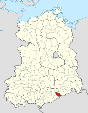
| Location of the district in the GDR | |
  |
|
The Brand-Erbisdorf district was a district in the Karl-Marx-Stadt district of the GDR . From 1990 to 1994 it existed as the district of Brand-Erbisdorf in the state of Saxony . His area is in what is now the Central Saxony district . The seat of the district administration was in Brand-Erbisdorf .
geography
location
The district began immediately south of Freiberg and extended to the ridge of the Osterzgebirge . There was a 10 km long border with Czechoslovakia . The closest border crossing was in Zinnwald in the eastern neighboring district of Dippoldiswalde . The Brand-Erbisdorf district was one of the smallest districts in the GDR in terms of area.
Neighboring areas
The Brand-Erbisdorf district bordered clockwise in the south, starting with the Marienberg , Flöha , Freiberg , Freital and Dippoldiswalde districts. In the southeast it bordered on Czechoslovakia.
Natural space
According to the location of the district in the northern Ore Mountains, the land surface of Brand-Erbisdorf rose 520 m above sea level to around 800 m on the Czech border. The lowest point of 385 m was in the valley of the Freiberger Mulde south of Freiberg. The Freiberg Mulde flowed through roughly the middle of the district from south to north in a deeply indented valley. With its tributaries, it subdivided the flat, undulating plateau of the lower Eastern Ore Mountains, which was made up of gray gneiss rock. This broken plateau sloped gently to the north. The upper Ore Mountains rose in one step in the south and reached the highest point of the circle in Drachenkopf (807 m). The landscape protection area "Obere Freiberger Mulde" was designated in the district.
history
The Brand-Erbisdorf district was created in the course of the GDR territorial reform on July 25, 1952 from the southern part of the Freiberg district and the western part of the Dippoldiswalde district . The district was assigned to the newly formed Karl-Marx-Stadt district . The town of Brand-Erbisdorf became the district seat.
The following 28 municipalities formed the new district:
- 23 municipalities from the Freiberg district :
Berthelsdorf i. Erzgeb., Brand-Erbisdorf, Cämmerswalde, Clausnitz i. Erzgeb., Dorfchemnitz b. Sayda, Friedebach, Gränitz, Großhartmannsdorf, Helbigsdorf, Holzhau, Langenau b. Brand-Erbisdorf, Lichtenberg i. Erzgeb., Mittelaida, Müdisdorf, Mulda, Oberreichenbach b. Brand-Erbisdorf, Obersaida, Rechenberg-Bienenmühle, Sayda, St. Michaelis, Voigtsdorf, Weigmannsdorf and Zethau.
- 5 municipalities from the Dippoldiswalde district :
Burkersdorf, Dittersbach, Frauenstein, Kleinbobritzsch and Nassau.
The only change in the area occurred on January 1, 1963, when Weigmannsdorf and Müdisdorf merged to form the Weigmannsdorf-Müdisdorf community . With the introduction of the new municipal constitution in the GDR, the district was given the name Landkreis Brand-Erbisdorf on May 17, 1990 . A district of the same area in the Free State of Saxony continued under this name until 1994.
economy
The industrial focus of the district was the district town with the VEB pressing and smithing plant "Einheit" and an operation of the VEB Kombinat Narva, in which fluorescent tubes were manufactured. In addition, there were smaller companies in light industry. Until the end of the 19th century, silver mining was the most important source of income. The Himmelsfürst mining area between Brand and Langenau was one of the most productive in the Freiberg area. Nevertheless, the mechanization of mining was a long time coming. It was not until 1844 that a steam engine was installed in the highest mine in the area, the “Reicher Bergsegen” mine south of Brand. At that time, around 200 machines were already running in Saxony. Industrialization, with a focus on metal processing, did not begin until after the railway was built at the end of the 19th century. In the valley of the Freiberg Mulde a railway line led to the border. A branch line ran via Brand-Erbisdorf to Langenau. The second branch line from Brand-Erbisdorf to Großhartmannsdorf has since been closed, as has the small railway line built in 1897 from Mulda via Dorfchemnitz to Sayda. Sayda is a compressor station on the “Northern Lights” natural gas pipeline, which imported natural gas from the Tyumen region in the Soviet Union via Czechoslovakia . The wooded ridges of the Osterzgebirge between Sayda, Rechenberg-Bienenmühle and Holzhau are recreational areas. Sayda accommodated around 2,000 holidaymakers a year in its FDGB holiday homes. In the lower Eastern Ore Mountains the plateaus were mainly occupied by arable land (rye, oats, barley and fodder plants). About a fifth of the agricultural area was used by permanent grassland. Accordingly, many LPGs specialized in cattle farming.
traffic
The Brand-Erbisdorf district was accessible from the road side by two long-distance roads , today's federal roads 101 (from Annaberg-Buchholz to Freiberg) and 171 . To the north of Freiberg near Siebenlehn, the district was connected to the motorway from Karl-Marx-Stadt to Dresden. On the railway side, the Nossen – Moldava v Krušných horách line and the Berthelsdorf – Großhartmannsdorf and Brand-Erbisdorf – Langenau lines for passenger and freight traffic were used.
Population data
Population overview of all 25 municipalities in the district that came to the re-established state of Saxony in 1990.
| AGS | local community | Residents | Area (ha) | |
|---|---|---|---|---|
| 3rd October 1990 | December 31, 1990 | |||
| 14017010 | Berthelsdorf / Erzgeb. | 924 | 914 | 1,221 |
| 14017020 | Brand-Erbisdorf , city | 9,577 | 9,490 | 1,186 |
| 14017030 | Burkersdorf , | 942 | 935 | 1,765 |
| 14017040 | Cammerswalde | 1,100 | 1.101 | 1,445 |
| 14017050 | Clausnitz / Erzgeb. | 1,151 | 1,148 | 1,441 |
| 14017060 | Dittersbach | 299 | 294 | 762 |
| 14017070 | Dorfchemnitz b. Sayda | 1,173 | 1,162 | 1,423 |
| 14017080 | Frauenstein / Erzgeb. , City | 1,368 | 1,356 | 1,297 |
| 14017090 | Friedebach | 574 | 569 | 1,461 |
| 14017110 | Großhartmannsdorf | 1,748 | 1,736 | 1,500 |
| 14017120 | Helbigsdorf | 463 | 458 | 847 |
| 14017130 | Holzhau | 501 | 491 | 3,622 |
| 14017150 | Langenau | 2,553 | 2,553 | 1,854 |
| 14017160 | Lichtenberg / Erzgeb. | 2,196 | 2,178 | 1,814 |
| 14017170 | Middle Aida | 663 | 654 | 787 |
| 14017180 | Mulda / Sa. | 1,818 | 1,803 | 1,856 |
| 14017190 | Nassau | 1,142 | 1,135 | 2,059 |
| 14017200 | Oberreichenbach | 131 | 130 | 320 |
| 14017210 | Obersaida | 367 | 369 | 572 |
| 14017220 | Rechenberg bee mill | 1,153 | 1,144 | 186 |
| 14017230 | St. Michaelis | 1,204 | 1,190 | 1,264 |
| 14017240 | Sayda , city | 1,761 | 1,765 | 2,057 |
| 14017250 | Voigtsdorf , | 803 | 793 | 1,530 |
| 14017260 | Weigmannsdorf-Müdisdorf | 927 | 947 | 1,501 |
| 14017270 | Zethau | 1,025 | 1,015 | 1,606 |
| 14017 | Brand-Erbisdorf district | 35,563 | 35,330 | 35,373 |
License Plate
Motor vehicles (with the exception of motorcycles) and trailers were assigned three-letter distinctive signs starting with the letter pairs TD and XD from around 1974 to the end of 1990 . The last number plate series used for motorcycles was XW 50-01 to XW 75-00 .
Individual evidence
- ↑ a b various (ed.): Diercke Lexicon Germany - German Democratic Republic and Berlin (East) . Georg Westermann Verlag GmbH, Braunschweig 1986, ISBN 3-07-508861-7 .
- ^ Federal Statistical Office (Ed.): Municipalities 1994 and their changes since January 1, 1948 in the new federal states . Metzler-Poeschel, Stuttgart 1995, ISBN 3-8246-0321-7 .
- ↑ Law on the self-administration of municipalities and districts in the GDR (municipal constitution) of May 17, 1990
- ↑ Saxony regional register
- ↑ Andreas Herzfeld: The history of the German license plate . 4th edition. German Flag Society V., Berlin 2010, ISBN 978-3-935131-11-7 , pp. 303 .
- ↑ Andreas Herzfeld: The history of the German license plate . 4th edition. German Flag Society V., Berlin 2010, ISBN 978-3-935131-11-7 , pp. 526 .