
Lichtenberg / Erzgeb.
| coat of arms | Germany map | |
|---|---|---|

|
Coordinates: 50 ° 50 ' N , 13 ° 25' E |
|
| Basic data | ||
| State : | Saxony | |
| County : | Central Saxony | |
| Management Community : | Lichtenberg-Weissenborn | |
| Height : | 311 m above sea level NHN | |
| Area : | 33.39 km 2 | |
| Residents: | 2692 (Dec. 31, 2019) | |
| Population density : | 81 inhabitants per km 2 | |
| Postal code : | 09638 | |
| Area code : | 037323 | |
| License plate : | FG, BED, DL, FLÖ, HC, MW, RL | |
| Community key : | 14 5 22 340 | |
| Community structure: | 3 districts | |
| Address of the municipal administration: |
Bahnhofstrasse 3A 09638 Lichtenberg / Erzgeb. |
|
| Website : | ||
| Mayoress : | Steffi Schädlich | |
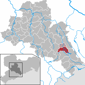
| Location of the municipality of Lichtenberg / Erzgeb. in the district of central Saxony | ||
  |
||

Lichtenberg / Erzgeb. is a municipality in the district of central Saxony in Saxony (Germany). With the neighboring community Weißenborn / Erzgeb. Lichtenberg forms the administrative community Lichtenberg-Weißenborn
geography
Lichtenberg lies in the valley of the Freiberg Mulde . Lichtenberg and its two districts are Waldhufendörfer. The seven-kilometer-long district of Lichtenberg is located east of the river on the Gimmlitz , which is dammed up south of the village to form the Lichtenberg dam. Weigmannsdorf and Müdisdorf are in a western side valley.
The highest point in the community is the Burgberg at 617 m.
Local division
Districts are Lichtenberg, Weigmannsdorf and Müdisdorf .
history

Lichtenberg is first mentioned in 1309 as Lichtinberc. The establishment of the place by Frankish colonists took place in the 12th century. In the 14th century the moated castle Lichtenberg , called "Ringelteich", was built in the valley, and presumably also in the 14th century the hilltop castle Lichtenberg on the castle hill. In contrast to the neighboring village of Weigmannsdorf, which belonged to the Frauenstein office , Lichtenberg, like its current district of Müdisdorf, was part of the Freiberg district office of the Electoral Saxony or royal Saxon district until 1856 . In 1506 Lichtenberg became the Freiberg Ratsdorf through purchase . It was not until 1838 that the place received self-administration. From 1856 Lichtenberg belonged to the Freiberg judicial office and from 1875 to the Freiberg district administration .
In 1912 Lichtenberg was connected to the electricity network. With the second district reform in the GDR, Lichtenberg came to the Brand-Erbisdorf district in the Chemnitz district in 1952 (renamed the Karl-Marx-Stadt district in 1953 ). The Lichtenberg dam was built between 1967 and 1973. On October 1, 1993, was carried incorporation of Weigmannsdorf-Müdisdorf . In 1994 the municipality of Lichtenberg / Erzgeb came. from the Saxon district of Brand-Erbisdorf to the district of Freiberg and in 2008 to the district of central Saxony.
Population development
The following population figures refer to December 31 of the previous year with the territory January 2007:
|
1982 to 1988
|
1989 to 1995
|
1996 to 2002
|
2003 to 2013
|
- Source: State Statistical Office of the Free State of Saxony
politics
Municipal council
Since the municipal council election on May 26, 2019 , the 14 seats of the municipal council have been distributed among the individual groups as follows:
- Free Voters Central Saxony eV (FWMS): 6 seats
- CDU : 5 seats
- General voter community (AWG): 3 seats
Culture and sights
Buildings
- Lichtenberg dam : The dam, built from 1967 to produce drinking water, is the most famous structure in the community.
- Church in Lichtenberg : The Lichtenberg Church was built in 1648 in the Baroque style. The interior was created during a renovation in 1799. The coffered ceiling, a complete dinner set from 1679 and two epitaphs from the 18th century are worth seeing .
- Visitor mine "Trau auf Gott Erbstolln" in Lichtenberg : The tunnel, which was excavated at the end of the 18th century , is particularly remarkable from a geological and mining point of view. The roof is partly formed by river gravel from the Gimmlitz , and the tunnel also has numerous year and passage signs , commodities and excavation signs.
- Church in Weigmannsdorf : The church, built in the 15th century, has beautiful ceiling paintings and a baptismal font made of pewter in the form of a shell (1688).
- Watermill in Weigmannsdorf : The building, already mentioned in 1550, served as a wood grinding mill until 1979, whereby the fully functional wood grinding shop has been preserved to this day. The mill was the home of the Saxon court sculptors George Heermann and Paul Heermann .

Church in Lichtenberg

View of the place

Lichtenberg dam

Church in Weigmannsdorf

Visitor mine "Trau auf Gott Erbstolln"


_Trau_auf_Gott_Erbstolln_02.jpg)
Economy and Infrastructure
traffic
_(6).jpg)
The Freiberg – Holzhau railway has a stop in Lichtenberg.
education
Lichtenberg has a primary school. The Gimmlitztalschule Lichtenberg (middle school) was closed in 2006.
The BBS of VEB Energiebau was located in Lichtenberg, No. 193 c (including training as an electrician and high-voltage fitter)
Personalities
Sons and daughters of the church
- George Heermann (around 1640–1700), court sculptor
- Paul Heermann (1673–1732), court sculptor
- Eberhard Luther (1932–2003), multiple world champion in bowling
- Volker Uhlig (* 1949), local politician (CDU)
literature
- Richard Steche : Lichtenberg. In: Descriptive representation of the older architectural and art monuments of the Kingdom of Saxony. 3. Issue: Amtshauptmannschaft Freiberg . CC Meinhold, Dresden 1884, p. 109.
Web links
- Official website of the municipality of Lichtenberg
- Lichtenberg / Erzgeb. in the digital historical directory of Saxony
- Müdisdorf in the Digital Historical Directory of Saxony
Individual evidence
- ↑ Population of the Free State of Saxony by municipalities on December 31, 2019 ( help on this ).
- ^ Karlheinz Blaschke , Uwe Ulrich Jäschke : Kursächsischer Ämteratlas. Leipzig 2009, ISBN 978-3-937386-14-0 ; P. 72 f.
- ^ The Amtshauptmannschaft Freiberg in the municipality register 1900
- ↑ Municipalities 1994 and their changes since January 1, 1948 in the new federal states , Metzler-Poeschel publishing house, Stuttgart, 1995, ISBN 3-8246-0321-7 , publisher: Federal Statistical Office
- ↑ Results of the 2019 municipal council elections
- ↑ https://www.lichtenberg-erzgebirge.de/seite/418815/wahlverbindungen.html