
Sayda
| coat of arms | Germany map | |
|---|---|---|

|
Coordinates: 50 ° 43 ' N , 13 ° 25' E |
|
| Basic data | ||
| State : | Saxony | |
| County : | Central Saxony | |
| Management Community : | Sayda / Dorfchemnitz | |
| Height : | 680 m above sea level NHN | |
| Area : | 35.3 km 2 | |
| Residents: | 1750 (Dec. 31, 2019) | |
| Population density : | 50 inhabitants per km 2 | |
| Postal code : | 09619 | |
| Area code : | 037365 | |
| License plate : | FG, BED, DL, FLÖ, HC, MW, RL | |
| Community key : | 14 5 22 520 | |
| LOCODE : | DE SYD | |
City administration address : |
Am Markt 1 09619 Sayda |
|
| Website : | ||
| Mayor : | Volker Krönert ( CDU ) | |
| Location of the city of Sayda in the district of central Saxony | ||
  |
||

_2006-07-15.JPG)
Sayda is a district town in the southeast of the district of Central Saxony . It is part of the Sayda / Dorfchemnitz administrative community and has been documented since the beginning of the 13th century.
geography
Location and area
The mountain town of Sayda is located in the Eastern Ore Mountains between the valleys of the Freiberger Mulde and the Flöha . The water tower stands at the highest point in the city at 680 m above sea level. NN . In the north is the Saydaer Höhe at 729 m above sea level. NN . In a clockwise direction, the place is surrounded by the Meisenberg ( 723 m above sea level ), the König-Friedrich-August-Höhe ( 736 m above sea level ), Hexenberg ( 679 m above sea level ) and the Voigtsdorfer Höhe ( 707 m above sea level). NN ). Large forests in the municipality are the mill wood, the black bush, the Tännicht and the old Gehau.

Sayda is located about 60 km southwest of Dresden , about 45 km southeast of Chemnitz , about 150 km southeast of Leipzig and about 140 km from Prague . The federal highway 171 runs through the village .
In 2016, the total area of the municipality consisted of 3% settlement area, 2.7% traffic area and 94.3% vegetation area (forest area 37.1%).
climate
In the area around Sayda there is an Atlantic dominated, moderately cool, humid, snowy low mountain range with over 1000 mm of precipitation per year. The annual mean temperature is 7 ° C. Due to its location in the Eastern Ore Mountains, the winters tend to be colder, the annual temperature fluctuations more pronounced and the precipitation lower than in other parts of Saxony. According to the reports of older chroniclers, the climate in the upper Ore Mountains in the past centuries must have been even rougher than it is today. Sources from this period tell of harsh winters in which the cattle froze to death in the stables and in April so much snow fell that houses and cellars were covered with snow. The population was regularly cut off from the environment. The Upper Ore Mountains were therefore often given the nickname Saxon Siberia in the past . The region is one of the most snow-sure areas in the German low mountain range. In particular southern weather conditions, foehn winds, but also the so-called Bohemian winds can occur.
| Jan. | Feb | March | Apr | May | Jun. | Jul. | Aug | Sep | Oct | Nov | Dec | Annual average | |
|---|---|---|---|---|---|---|---|---|---|---|---|---|---|
| Temp. ( ° C ) | −1.5 | −1.1 | 1.7 | 5.9 | 10.8 | 13.5 | 15.6 | 15.3 | 11.3 | 6.8 | 1.5 | −1.4 | 6.5 |
| Precipitation ( mm ) | 79 | 71 | 85 | 63 | 85 | 89 | 120 | 114 | 75 | 61 | 83 | 87 | 1012 |
geology

Regionally, the Sayda structure is formed around the Saydaer Höhe. This has a red gneiss (muscovite gneiss) in the center, which is superimposed by lateral overfolding of gray and red gneiss. Rarely occurring minerals such as mottramite , liroconite , pseudomalachite and chalcophyllite can also be found in this area .
City structure
The districts belong to Sayda
- Friedebach (incorporated in 1994)
- Mortelgrund (incorporated in 1925)
- Pilsdorf (reclassified on July 1, 1950)
- Ullersdorf (incorporated on July 1, 1950)
history
First mention and development
Zavidowe, d. H. The place of Zavid has been traceable since 1196 and was first mentioned in documents in 1207 in the deed of foundation of the Cistercian monastery of Ossegg . Sayda is most likely the oldest settlement in the Upper Ore Mountains. As early as 1196 it belonged to the Count of Bilin and chamberlain to the King of Bohemia, Slauko V. von Riesenburg . Slauko founded the Ossegg monastery in 1196 and gave this monastery the right of patronage and the tithe of customs and court in Zavidowe (also Seydowe) and ordered that the forest beyond the monastery and half of the direct income of the villages founded there be cleared at his expense should flow to the church at Ossegg. Most likely, Sayda was already a fortified city at that time. The "castru et civitas" (castle and fortifications) was first mentioned in 1289. The origin of Sayda is before 1196, but as impenetrable as the Miriquidi forest was, the time it was founded is so impenetrable, especially since many historical documents were destroyed by earlier city fires are. One thing is for sure, Sayda is of Slavic origin. Sayda is therefore a very old city and gained great importance in the early Middle Ages. In the 13th century the area was actually settled from the south by the Bohemian aristocratic family of the Hrabischitz .
The Ore Mountains Pass from Sayda via the Deutscheinsiedler Sattel , known as the Böhmische Steig or Alte Salzstraße , played a key role in the development of the place . This important route from Central Germany across the Ore Mountains into the Bohemian Basin was created in the late 11th and 12th centuries. Older research assumes the existence of this traffic connection since the 7th century, but there is no reliable evidence for this (as of 2014).

With the sovereign castle, Sayda offered protection for the Bohemian Road and the settlements that had developed. In documents from 1253 and 1289 the settlement is called Castrum et civitas Seydowe . Margrave Heinrich the Illustrious acquired Sayda in the middle of the 13th century by giving up his claims to Austrian goods. The Sayda area was then sold to Bohemia before it finally became the Margraviate of Meissen at the beginning of the 14th century .
The contract to Mügeln sealed on 18 October 1300 that the Bishop of Meissen by the abbot and convent of Cistercian - monastery Ossegg (in the diocese of Prague located) the vicar of the parish Sayda along with the surrounding churches and chapels belonging to the place itself Sayda , as well as the pastors and their leaders with all spiritual rights. A photocopy of this document is in the local history museum in Sayda. In 1324 the von Bergowe family was enfeoffed with Sayda and Purschenstein by Landgrave Friedrich in Thuringia . In 1352 Burgrave Meinher IV. Von Meißen , brother-in-law Borso IV. Von Riesenburg , became feudal lord, who however immediately passed the fief on to the von Schönberg family. From then on, the von Schönberg family owned the fief. The first liege lord was Heinrich von Schönberg.
In 1451 Bernhard von Schönberg was entrusted with Sayda. In 1476 he went to Jerusalem with the Saxon Duke Albrecht the Courageous . On the way back he fell ill and decreed in a will that a hospital for sick and needy people should be built in Sayda, so the St. Johannis Hospital was built in 1508 . The multi-century building was supposed to be demolished after 1990, but the Erzgebirgszweigverein Sayda, which was re-established on February 17, 1990, managed to keep the hospital - the oldest house in town. The association renovated the building and opened the Erzgebirgisches Heimatmuseum Hospital zu St. Johannis on May 22, 1993 .
.jpg)
Wars, disasters and misfortunes
In the course of its history, Sayda has suffered an above-average number of sometimes devastating city fires.
- March 31, 1435: A city fire destroyed large parts of the town. Presumably the Hussites had started the fire.
- October 30, 1559: A fire destroyed 200 houses and barns in the city. The town hall, church and school also fell victim to the flames.
- 1657: 13 houses and 10 barns were destroyed in a fire.
- August 3, 1681: 17 barns burned down as a result of a lightning strike .
- 10/11 February 1702: Around midnight a rapidly spreading fire broke out, which destroyed 44 houses, including a church, parish, deaconry and town hall tower, as well as 14 barns.
- January 10, 1743: In a fire caused by carelessness, 26 houses and 19 barns go up in flames within four hours.
- August 31/1. September 1842: On the evening of August 31, a fire broke out in a barn in front of the Freiberg Gate, which destroyed large parts of the city within eight hours. In this last big city fire, 145 houses including the outbuildings and back buildings and 52 barns went up in flames, only 38 houses and 26 barns remained undamaged. The fire left 289 families (approx. 1,100 residents) homeless.
- June 8, 1876: 24 barns burned down.
- July 2, 1914: A fire , presumably caused by arson , destroyed ten houses in the historic district of "Plan" (Anger).
- July 4, 1978: In the compressor station of the Northern Lights natural gas route near Sayda , an explosion occurred in which two people were killed.
Population development
| 1486 to 1764 | 1834 to 1929 | 1982 to 1988 | 1989 to 1995 | 1989 to 1995 | 2003 to 2013 | 2014 to 2017 |
|---|---|---|---|---|---|---|
|
|
|
|
|
|
|
religion
54% of the population are Protestant, only 2% Catholic. The parish of our dear women Sayda belongs to the church district Freiberg of the Evangelical Lutheran regional church of Saxony . The Catholics are assigned to the parish of the Immaculate Conception in Marienberg , which belongs to the Dresden deanery of the Dresden-Meißen diocese . Once a month there is an evening mass in Sayda; otherwise the next church service station is the St. Elisabeth chapel in Neuhausen / Erzgeb.
politics
City council
Since the local elections in Saxony in 2019, the 11 seats of the city council have been distributed among the individual groups as follows:
- Voting Association of Craftsmen and Businesses (WvHG): 6 seats
- Voters' association "We for Sayda" (WfS): 5 seats
mayor
The incumbent Mayor Volker Krönert was confirmed in office in June 2015 with 64.6% of the votes. His predecessors are included in the list of mayors of Sayda .
coat of arms
Blazon : “A lion divided in red and green in gold .” The city bears the coat of arms of the Lords of Schönberg, who had lived at Purschenstein Castle (Neuhausen) since 1336 . The oldest known seal is dated from 1454.

According to legend, a Schoenberger fought with a lion on a crusade in Palestine and the deadly wounded animal died in the undergrowth of a river. When it was pulled out, its abdomen was colored green by algae and aquatic plants.
Town twinning
-
 Meziboří (1995)
 -
 Sogliano al Rubicone (1999)
 -
 Strenči (2005)
Culture and sights
For centuries the culture of Sayda was shaped by the changing economic conditions in trade, mining, handicrafts, forestry and home work. In addition to the typical Erzgebirge folk art and the Erzgebirge cuisine , many regional specialties have emerged. Especially in the Christmas season there are many traditions that sometimes differ from family to family. The following illustrations are intended to give an overview of the city and its most famous buildings. In the Sayda town song Mei Saade , some buildings are also named.

Church "To Our Lady"

Erzgebirgisches Heimatmuseum Hospital zu St. Johannis

Coat of arms town hall door Sayda

Church and elementary school

Local pyramid Sayda

View of Dresdner Strasse Sayda

Dresdner Strasse Sayda

View of the church

Sayda war memorial
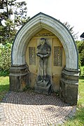
Memorial First World War Sayda
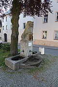
Sayda fountain

Kurt Preißler - Malerweg

Wind farm near Sayda
_Stadtkirche_Frauenkirche.jpg)

_2006-07-15.JPG)


.jpg)


In 2014 the so-called Saydaer Malerweg was established, which leads through the city and the surrounding area to the Kleiner Vorwerk and the Mortelgrund. The painters and amateur artists Kurt Preißler (1893–1968), Paul Bloss (1898–1980) and Paul Tränkner (1885–1967) are remembered.
Museums
- Erzgebirge Heimatmuseum in the St. Johannis Hospital , opened here in 1993
- Fire brigade museum in the old syringe house
- Road construction museum
- Mittelmühle and tube drilling in the Friedebach district
Further monuments are listed in the list of technical monuments in the district of central Saxony and in the list of cultural monuments in Sayda .
societies
sports clubs
- SSV 1863 Sayda Spiel- und Sportverein 1863 Sayda eV
- Privileged Bürgererschützengilde Sayda 1816/2006 eV
- Sayda Ski Club
- Dynamo Fan Club Sayda
Associations for tradition and history
- City Association Sayda eV
- Tourist association Bergstadt Sayda / Erzgebirge u. Environment eV
- Erzgebirgszweigverein Sayda eV
- Heimatverein Mortelgrund - Alte Salzstraße eV
- Women's group Ullersdorf
Artistic associations and organizations
- DKS Sayda eV (Decoration and Carnival Club Sayda)
Choirs
- Sayda church choir
- Carolers
- Trumpet Choir
- Folk Choir Sayda e. V.
- Friedebacher fire brigade musicians
Regular events


The Bergstadtfest is one of the regular events in Sayda. This always takes place on the last weekend in August. 2017 was the 46th event. It is significantly older than the Freiberg Bergstadtfest. Furthermore, the Christmas market takes place every 4th Advent on the historical plan.
Buildings
- Sayda Castle
- Sayda water tower
- Church To our dear women ( parish church St. Marien )
three-aisled late Gothic hall church from 1391, the nave was built after 1502, the choir is dated to the 14th century. On the south side there is a porch with twisted rib vaults and a triangular vestibule with cell vaults. Two epitaphs from the von Schönberg family from the 16th and 17th centuries have been preserved in the interior . Comprehensively renovated inside in 1892, 62 m high tower, second highest hall church in the former Freiberg district.
The church building is a cultural monument . - Hospital St. Johannis : is a simple baroque building, started in 1467 and has a half-timbered upper floor as a special feature , which was added in 1784. It is the oldest surviving building in the city, used as a hospital until 1945, then a residential building. The hospital and the neighboring burial church from 1508 are cultural monuments.
- Architect house: construction in the early twentieth century, demolished in 2009
- Official House: Erected for the officials of the city of Sayda in 1908.
- Triangulation column: On the Saydaer Höhe (about 1500 m north of the church) is the surveying station 88 of the Royal Saxon Triangulation, built in 1869 .
- Hotel zum Bad: Built in 1864, demolished in 2017
Economy and Infrastructure
economy

Sayda owed its prosperity in the Middle Ages to its location on the Old Salt Road from Halle to Prague. Sayda developed into a trading town in the 14th century, where trade fairs were held several times a year. Only with the second mountain cry in the Ore Mountains in the 15th century and the associated flourishing of new mountain towns in the Western Ore Mountains, such as Marienberg, Annaberg and Schneeberg, did this long-distance trade route lose its importance in favor of other Bohemian Cliffs or Ore Mountain passes . Sayda has been a state-approved resort since 2012 and uses this title to attract tourists. In 2015, the community website names 22 small and large companies in Sayda and its districts.
traffic
From 1897 to 1966 Sayda was the terminus of the Mulda – Sayda narrow-gauge railway . The former station building in Sayda has been preserved. It is used as the main building of the Sayda day care center Bahnhofsspatzen and accommodates around 100 children on weekdays.
Educational institutions
- Primary school named after the cantor and local researcher Max Rennau
- Sayda High School (Sayda Mining School), built in 1977 and Hồ Chí Minh School until 1990 . A modernization took place in 2010.
Leisure and sports facilities
- Sayda ski area with 45 km of groomed trails, 1 illuminated toboggan slope, horse-drawn sleigh rides, snowmobile safaris
- 2 sports fields
Personalities
Honorary citizen
- Otto von Bismarck (April 1, 1895)
sons and daughters of the town
- Disciple Wolfgang (1518–1564), pastor, Thomaskantor
- Belman, Adam (1530-1603), town clerk
- Cuno (nee Watzlau), Dorothea (1631–1694), wife of the princely Saxon magdeburg house bailiff in Halle
- Adam Friedrich Pezoldt (1679–1761), chemist
- Carl August Hänsel (1799–1867), composer (dances, marches, ballet music) and music master, 1836–1867 cellist of the royal Saxon court orchestra
- Göpfert Ernst (1840–1922), folklorist and dialect researcher
- Horst Stephan (1873–1954), Protestant theologian and publicist
- Oskar Beier (1875–1941), politician (economic party) and member of the Reichstag
- Curt Böhme (1889–1968), politician (SPD, SED), 1948–1956 Lord Mayor of Gera , honorary citizen of Gera
- Carl Rudolph (1891–1955), school reformer
- Kurt Preißler (1893–1968), painter a. Graphic artist
- Gerhard Kluge (* 1935), Germanist
- Rainer Dietel (* 1937), Nordic combined skier
People related to the city
- Ottilia Ludwig (1813–1900), writer
- Adolf Drechsler (1815–1888) astronomer, meteorologist and philosopher
- Dagmar Blei (* 1940), linguist and university professor
- Uwe Bellmann (* 1962), cross-country skier
- Tina Zemmrich (* 1982), journalist, author and television presenter
- Anne Winkler (* 1994), cross-country skier
literature
- Festival committee of the 750th anniversary of the city of Sayda (Ed.): 750th anniversary of Sayda / Erzgebirge from 15. – 23. June 1957. Sayda 1957.
- Carl Gustav Flade, Friedrich Wilhelm Thost: Description of the fire accident that took place on the night of August 31st to September 1st, 1842 in the city of Sayda . Rudolph and Dieterici, Annaberg 1842 (digitized version)
- Gottfried Krönert (Hrsg.): Chronicle and time table of the mountain town Sayda. Sayda 2000.
- Sayda . In: August Schumann : Complete State, Post and Newspaper Lexicon of Saxony. 10th volume. Schumann, Zwickau 1823, pp. 191–193.
- Richard Steche : Sayda. In: Descriptive representation of the older architectural and art monuments of the Kingdom of Saxony. 3. Issue: Amtshauptmannschaft Freiberg . CC Meinhold, Dresden 1884, p. 118.
- Statistical report - Federal Statistical Office PDF ›A_V_1_j09_SN
Web links
- Atlas Central Saxony
- Sayda in the Digital Historical Directory of Saxony
Individual evidence
- ↑ Population of the Free State of Saxony by municipalities on December 31, 2019 ( help on this ).
- ↑ Source: Measured values DWD 1973–2000 (temperature), measuring station Rauschenbach at 615 m above sea level. NN at the dam wall, 1981–2010 (precipitation), measuring station Sayda, ID 4410 670 m above sea level. NN , latitude: 50 ° 43 ', longitude: 13 ° 26'
- ↑ Source from 1982: State Statistical Office of the Free State of Saxony. The population figures from 1982 onwards refer to December 31 of the previous year with the territorial status January 2007
- ↑ census database
- ↑ [1]
- ↑ https://www.statistik.sachsen.de/wpr_alt/pkg_s10_bmlr.prc_erg_bm?p_bz_bzid=BM151&p_ebene=GE&p_ort=14522520
- ↑ Malerweg - Bergstadt Sayda (accessed on June 5, 2019)
- ↑ Sayda parish with brief information on the church building
- ^ A b Georg Piltz: Art guide through the GDR . 4th edition. Urania-Verlag, Leipzig / Jena / Berlin 1973, p. 466.
- ↑ economy in Sayda on www.sayda.eu ; Retrieved February 18, 2014.