
Sayda water tower
| Sayda water tower | |
|---|---|
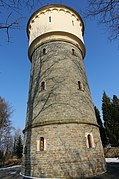
 Sayda water tower - March 2018 |
|
| Data | |
| Year of construction / construction time: | 1893 to 1894 |
| Architect: | Ing.Cramer |
| Construction: | Builder J. Neuber |
| Tower height: | 25 m |
| Usable height: | 15 m |
| Container height: | 15 m |
| Container type: | Intze 1 container |
| Container volume: | 200 m³ |
| Operating condition: | Water supply for Sayda and the surrounding area |
| Conversion: | No |
| Monument protection: | Yes |
The Sayda water tower is next to the burial church at the highest point in the city. The 25 meter high water tower is next to the church tower, a highly visible landmark and is a central, high-altitude location, a landmark of the city with local image formative effect.
History of the Sayda water supply
The catchment area of the mountain town is at an average altitude of 660 m above sea level. NN up to 680 m above sea level NN . Seven water pipe tours were laid out over the centuries to supply the residents with water, as there was no spring in the entire city that carried sufficient water. From this time only two names of those from the higher spring areas and pipes laid with wooden pipes have survived. This included the almost 3 km long meadow-water tube tour, described as a true mining wonder, as well as the very important Gottesacker water tube tour. These led the water into the city and fed specially set up water troughs, which were a special ornament of the city at that time. The exact course of the water pipes and the locations of the springs are no longer known today. Since the latter must be higher than the city, only source areas in the Mühlholz and in the direction of the cross fir are possible.
Despite these enormous expenditures (combined with high costs) for the water supply into the city, chaotic conditions had developed in 1892. The trigger was a prolonged drought which was exacerbated by the following factors.
Climate / famine
In the 19th century, the climate in Central Europe was significantly colder than it is today ( small ice age , high glacier level in 1848, year without summer 1816). Due to the low mountain range, people very often had to suffer from these harsh natural conditions. The vegetation was sparse and the winters hard and long. There were often famines which were exacerbated by the additional drought in 1892.
Deforestation
Due to the massive demand for timber (mining, construction timber and firewood), there was hardly any forest in the region at the end of the 19th century. This can also be clearly seen in the maps that were created in the 19th century. The massive deforestation led to a deterioration in the drinking water supply as the groundwater table fell.
illness
Typhoid fever, which was common at the time, was particularly widespread in south-west Germany. Due to the lack of sewers and the public use of the open water troughs, a typhus epidemic also broke out in Sayda. From today's point of view, the path of spread can be traced, since the use of surface water and the low run-on of fresh water - favored by high temperatures - resulted in a high level of germs. Combined with a lack of hygiene at the extraction points, the infectious disease spread quickly. No deaths from this period are known.
General resentment due to the scarcity of water and the quality of the drinking water
The small existing storage volume of the wooden water troughs and the low inflow also led to resentment. As early as the Middle Ages, guard posts were set up in dry summers to control the water extraction. Most likely, the lack of water was also the reason why the city experienced an above-average number of city fires that destroyed entire districts. At low temperatures, the city was also cut off from the water supply because the pipes froze up or burst. The wooden pipes often made an unpleasant taste in the drinking water noticeable, with older pipes the quality of the water was often questionable.

Construction of a first supply line
As a result of the points mentioned, the urban community was in dire straits, as the population continued to press for remedial action. The chronicler Walter Göthe wrote:
- “Since, despite the most intensive efforts, no further water could be brought into the city by means of natural slopes, the source finder Beraz was cited to Sayda to explore source areas. With good success he was able to explore a rich spring in the so-called 'Fleckenwiesen'. The water appeared suitable and productive. "
This statement is interesting because the headwaters and the Fleckenwiesenbach are shown on the map made by Sayda around 1800. The area was therefore not unknown. Furthermore, Göthe writes:
- “The Central Office for Public Health found the water to be sufficiently pure drinking water. The council's board therefore turned its attention to this source area. At great expense, it was possible to use a pump system to transport the water found to the highest elevation and from there to let it flow into the city in a pipeline system. A gigantic request for the small town of Sayda at the time. "
Construction of the water tower and the high pressure pipeline
Another year of drought in 1893 finally forced action. Again a strong resistance from the population grew against the city council under the mayor Hermann Rudolf Uhlich. The council board and the municipal colleges decided to build a high pressure water pipe and commissioned the Königin-Marienhütte in Cainsdorf with the execution. Construction began in 1893.

Technical details
tower
The tower was built at the highest point in the city. J. Neubert from Friedebach is listed as the master builder of the 25 meter high natural stone tower, who built the tower according to the Intze principle . The 200 m³ water tank, the bottom of which is drawn in at an angle and then rests in a ring on the shaft of the tower, enables a slim support structure. In contrast, the inner area of the bottom is convex upwards. No horizontal forces, only vertical forces are introduced into the tower shaft, which can therefore be made less massive. This design was used in Germany between 1885 and 1905 in particular. The water tower is given a slightly conical shaft that is accentuated by a profiled cornice above the high base zone as well as the chiseled sandstone walls on the arched portal and the regularly arranged arched windows. The plastered tank floor, which surrounds the steel water tank of the Intze I type, protrudes slightly and is closed off by a round arch frieze below the conical roof. On the northeast side there is an entrance area that protrudes slightly from the base.
Waterworks with high pressure water pipes
From the Queen Marienhütte in Cainsdorf near Zwickau - in addition to the steel water tank - the associated high-pressure water pipes (600 m long and 60 meters of height bridging connection between the waterworks and the tower) and the waterworks were built south of the city. The water of the Fleckenwiesenbach springs from the "Fischhältersbrunnen", which was used the year before for the water supply. Göthe wrote:
- “The sources are about 4 to 5 meters below the surface of the earth. When it emerged from the rock, it was recaptured and kept in such a way that day water cannot get down to them. "
Even in dry phases, a volume of 210 l / min reaches the walled-in basin. The output of the pump system from 1901 was 249.6 l / min. This was in use for around 18 hours a day. By taking advantage of the elevated position and the height of the water tower, there was sufficient water pressure in the entire city network. It was not documented whether the house connection lines were also laid from the Queen Marienhütte.
opening
On October 8, 1894, the entire system was ceremoniously put into operation. The required financial resources of 75,000 marks were covered by an amortizable bond.

Since then, the city has never faced another water calamity . The operating expenses were always fully covered by the water interest. The creation of the high pressure water pipeline is one of the most important events in the local history of Sayda.

Sayda power station
The construction of the Sayda power station on December 1, 1898 on a private basis was also important for the water supply. The city later acquired the facility. This enabled a 7.5 kW electric motor (originally only a 4 HP petroleum motor) to be operated in the machine house for 24 hours.
sewage
The construction of a high lock for the city's wastewater began in 1900. With the implementation of the above projects, the city of Sayda kept up early on with the larger cities.
Extension 1911
Despite the water shortage prevailing everywhere in 1911, the Sayda water supply has proven itself brilliantly. This year, with less than 250 mm of annual precipitation, another drought year occurs, which was not repeated until 1982. In order to have another buffer for the city, it was decided to build another basin with 50 m³ water content - which should be used when there is extremely high water consumption. Another 4600 marks had to be spent on this collection container. In 1911 the city drew 41,316 m³ of water. For which 3453 operating hours of the pumps were necessary. The electrical work required for this cost 1895 marks.
Current water supply to the city
The water tower is still in operation today and as an early testimony to the central urban water supply at the end of the 19th century, it is of local and technical historical importance. The urban water system was organized by the state during the GDR era. After 1991 this task was taken over by the Freiberg Water Association . Today it is mainly used as a buffer for the water supply. A general overhaul took place in 1995–96. The water tower can only be viewed from the outside; it is not possible to open it to visitors. The last opening for visitors was as part of the 800th anniversary of the mountain town of Sayda.
The waterworks is no longer used today and is again the property of the city.
gallery

Description Wasserturm Sayda
Sayda water tower - March 2018
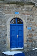
Entrance to the water tower

View from the city over the Fleckenwiesen to the waterworks (May 2018)

View from the waterworks towards the city (May 2018)

Sign at the Sayda waterworks


swell
- http://www.sayda.eu/tourismus/museen-und-denkmaeler/
- Documents of Sayda City Archives - The water supply in the mountain town of Sayda through the ages (extract from Walter Göthe's chronicle)
- Extract from the city newspaper from 1894
Individual evidence
- ^ Complete State, Post and Newspaper Lexicon of Saxony. Volume 10, August Schumann, Verlag der Gebrüder Schumann, 1823.
- ^ Mathias Döring: Weilburg and its water. The water supply of the baroque residence in the 18th and 19th centuries (= writings of the German Water History Society (DWhG) eV special volume. 1, ZDB -ID 2299939-5 ). German Water History Society (DWhG), Siegburg et al. 2005, pp. 19–20.
- ↑ zagermann.de
Coordinates: 50 ° 42 ′ 35.6 " N , 13 ° 25 ′ 25.2" E