
Flea
| coat of arms | Germany map | |
|---|---|---|

|
Coordinates: 50 ° 51 ' N , 13 ° 4' E |
|
| Basic data | ||
| State : | Saxony | |
| County : | Central Saxony | |
| Height : | 275 m above sea level NHN | |
| Area : | 27.76 km 2 | |
| Residents: | 10,696 (Dec. 31, 2019) | |
| Population density : | 385 inhabitants per km 2 | |
| Postal code : | 09557 | |
| Primaries : | 03726; 037292 (Hetzdorf) | |
| License plate : | FG, BED, DL, FLÖ, HC, MW, RL | |
| Community key : | 14 5 22 140 | |
City administration address : |
Augustusburger Strasse 90 09557 Flöha |
|
| Website : | ||
| Lord Mayor : | Volker Holuscha ( The Left ) | |
| Location of the city of Flöha in the district of central Saxony | ||
  |
||

The large district town of Flöha is a small Saxon town in the district of central Saxony . After the first documentary mention in 1346, the area on the northern edge of the Ore Mountains at the confluence of the Flöha and Zschopau rivers developed into an industrial community with the onset of industrialization in the 19th century, which was elevated to a town on November 8, 1933. The current urban area of the sub-center, which is directly adjacent to the city of Chemnitz , emerged from the amalgamation of communities in 1920 and 1962.
geography
The city of Flöha is located in the basin of the same name, which was cleared at the foot of the Lower Ore Mountains by the rivers Flöha and Zschopau flowing together there . At this confluence of the two rivers, four formerly independent municipalities form what is now the urban area of the city that has grown together.
Neighboring communities
The following communities border on the city of Flöha. They are called in clockwise direction in the northeast: Frankenberg / Sa. , Oederan , Augustusburg , Chemnitz and Niederwiesa .
City structure
The urban area of Flöha consists of the districts Flöha, Gückelsberg , Plaue , Bernsdorf and Falkenau (with its district Hetzdorf ).
history
.jpg)
From the foundation to the Thirty Years War
Flöha emerged as a single row forest hoof village in the decades after the middle of the 12th century. It was first mentioned in a document in 1399, when a "Johannes pharer zcu der Flaw" was mentioned in a Chemnitz document. This is also the first indirect mention of the village church of Flöha, which was laid out immediately with the foundation of the place - probably as the Georgskirche. The often assumed first mention of Flöha in the Meißner diocese register is based on an error, since the oldest surviving version of this register dates from 1495 (and not from 1346). Flöha's oldest building that can be definitely dated is the late Gothic choir of the “Georgenkirche” from around 1500/1510. However, building fabric from the Romanesque period (2nd half of the 12th or 1st half of the 13th century) may have been preserved in the nave. With the exception of the late medieval polygonal choir, the church was given its present form through a Baroque renovation in the middle of the 18th century and a historicist renovation in 1880.
From the Thirty Years War to the end of the 19th century
With the Thirty Years' War and the associated murders, fires, famine and the subsequent plague, the population was reduced by a quarter in one year from 1632. Numerous farms were destroyed. The Seven Years' War also went hand in hand with further hardships. Numerous recurring floods did not allow the settlement areas of the four villages to grow together, but rafting developed into an important branch of the economy on both rivers.
.jpg)
Up until the late 19th century, Flöha preserved the rural character of its settlements, the areas were oriented towards agriculture. With the establishment of the first cotton spinning mill in 1809, Flöha became an industrial location, which marked the beginning of the industrialization of the place that would shape the coming decades. The second spinning mill was founded in Flöha in 1817, and Gückelsberg followed suit with its first spinning mill in 1830. In the entire area around Chemnitz, industrialization influenced the character of the communities. The prestigious Clauss cotton spinning mill made Flöha an up-and-coming industrial community.

.jpg)
.jpg)
A further step in this development was the connection of Flöhas to the Saxon railway network with the connection between Chemnitz and Annaberg in 1866, the line to Freiberg and Dresden built three years later and the construction of the branch line to Reitzenhain, which branched off in Flöha . This accelerated the further settlement of important factories such as the colored paper and tulle factory " KG Carl Siems & Co. " in Plaue, the steam boiler construction and a wood grinding shop in Flöha. Until 1856, Flöha belonged to the Electoral Saxon or Royal Saxon Office of Augustusburg , formerly "Office Schellenberg". After the end of the Saxon constitution of offices in 1856, Flöha was under the jurisdiction of the Augustusburg court office . The neighboring town of Plaue was raised to the seat of the newly founded Amtshauptmannschaft Flöha in 1874 , which clearly reflected the increase in importance of the past decades. This decision led to more offices such as the Allgemeine Ortskrankenkasse in 1884 and the Gemeindesparkasse in 1895.
Flöha in the 20th century
Gückelsberg made the decision in 1920 to merge with Flöha. In 1930 a main post office and a technical and commercial school were opened in the city. It was not until November 8, 1933, when the city was elevated to the status of a formal area, the importance that Flöha had acquired through industry. In the gym in Plaue (Flöha-Süd), the SA and SS established the Plaue concentration camp on March 9, 1933 , which existed until June 10, 1933 and was passed through by a total of 600 prisoners who were exposed to the most severe abuse. After the camp was closed, the remaining prisoners came to Colditz , Sachsenburg or Augustusburg Castle . At the front of the gym, a relief with scenes from everyday camp life reminds of the crimes. A new train station followed in 1934, and further residential areas were created in the period that followed.
During the Second World War , a satellite camp of the Flossenbürg concentration camp was operated from March 1944 to April 1945 in today's Flöha plant of Oberlungwitzer Textilwerke GmbH . The front company Fortuna GmbH , which was based there at the time and where 600 prisoners had to manufacture aircraft parts under extreme living conditions, belonged to the Erla machine works in Leipzig.
After the Second World War had no direct impact on Flöha, the city was occupied by the Soviet Army in 1945 . In 1952, through the second district reform in the GDR, Flöha became the district town of the Flöha district in the Chemnitz district (renamed the Karl-Marx-Stadt district in 1953 ). On January 1, 1962, Plaue merged with Flöha, also because the settlement areas were overgrown and the economic connection had existed for a long time. The industrial site and district town of Flöha was still productive during the GDR, new residential areas, a Catholic church, new childcare and school facilities were built.
At the location of today's restaurant “Finkenmühle”, the “royal castle mill at Altenhayn ” was built as a grain mill in 1722 . In 1822 it was first mentioned under the name Finkenmühle at the Sachsenburg Rent Office , apparently due to the Finkenwiese located downstream next to the mill. From 1879 the Chemnitz manufacturer Heinrich Friedrich Schnicke is the owner of the mill, builds a turbine house and enlarges the mill into a factory wood grinding shop. In 1938 the mill was bought by Erwin Oscar Melchior, a businessman from Chemnitz, who founded the company "Plitz Akkumulatoren Flöha" together with Herbert Plitz and produced car and motorcycle batteries in the Finkenmühle. In 1972 VEB Vorrichtungsbau Hohenstein-Ernstthal became a new owner due to the expropriation. In 1986 the old buildings were partially demolished and a company training center with a public restaurant was built. When the community of Altenhain was incorporated into Frankenberg / Sa. In the district of Hainichen, the "An der Finkenmühle" settlement remained in the district of Flöha and was reclassified to Flöha on January 1, 1994 .
With the political change and the reunification of Germany, industry in the city collapsed, a high number of layoffs in the industrial sector was the result, which also triggered increased emigration to the western federal states. In 1994, with the amalgamation of the districts of Flöha, Freiberg and Brand-Erbisdorf, the city lost its status as a district town and thus became a major district town. Flöha was the third largest city in the Freiberg district , which existed until 2008 . Since then it has belonged to the Central Saxony district.

In 1999 Flöha celebrated its 600th anniversary in the form of a large club festival, including a parade and a three-day festival at the festival area between the Auenstadion and the grammar school.
On June 29 (Falkenau) and June 30, 2011 (Flöha), the municipal and city councils of Falkenau and Flöha decided on a voluntary merger that took effect on October 1, 2011. The administrative community Flöha was dissolved.
origin of the name
The place was named after the river; There are different linguistic explanations for the origin and the original meaning of the name. The linguist Ernst Eichler and the onomologist Hans Walther see the origin of the name in the Germanic word flouwan, flewan , which was Middle High German vlöuwen and in Old Sorbian plav (iti) and meant to flood, rinse, float . The Flöha river should be understood as the one on which rafts or washes were made , Old Sorbian Plava , Old or Middle High German Flawa .
Historical place name forms
The following spellings can be found in documents for the location
- 1399: zcu the Flaw
- 1445: Fleye
- 1449: Floye
- 1495: Flew
- 1539/40: the fleas
- 1728: Flöha
Population development
.jpg)
The following population figures refer to December 31 of the previous year with the area as of August 2008:
before 1980
|
1980 to 1989
|
1990 to 1999
|
2000 to 2009
|
2010 to 2019
|
- Source: State Statistical Office of the Free State of Saxony, as of September 30, 2013
Incorporations
- April 1, 1920: Gückelsberg
- January 1, 1962: Plaue with the Bernsdorf district
- October 1, 2011: Falkenau with the district of Hetzdorf
Attractions
Buildings and green spaces

.jpg)
- Hetzdorf Viaduct in the Falkenau district.
- George Church
- Half-timbered buildings
- Old cotton industrial site
- Geological collection
- Samuel-von-Pufendorf-Gymnasium,
received the German Architecture Prize in 1997 - blue wave,
a worth seeing pedestrian and cycle path bridge over the B 173 and the railway; for this there was the German Bridge Prize in 2012
Memorials
- Memorial at the entrance to the Flöha plant of Oberlungwitzer Textilwerke GmbH in memory of the concentration camp inmates who were victims of forced labor here during the Second World War . Some were hanged in the factory yard
- Memorial relief at the Plaue gymnasium in Flöha-Süd (see history)
- Graves at the Flöha-Süd forest cemetery for four unknown Poles who were deported to Germany during the Second World War and were victims of forced labor
politics
City council
After the local elections on May 26, 2019, the Flöha City Council consists of 22 members and the mayor, who is entitled to vote, as his chairman.
.jpg)
| Party / list | Share of votes | Seats | Graphic seat distribution 2019 |
| CDU | 37.8% | 9 | |
| AfD | 27.9% | 6th | |
| THE LEFT | 16.6% | 4th | |
| FDP | 9.6% | 2 | |
| SPD | 8.2% | 1 | |
| total | 100% * | 22nd | |
| * after eliminating rounding errors | |||
The Lord Mayor is an additional member of the city council and its chairman. Since the end of July 2015, this has been Volker Holuscha (Die Linke), who replaced Friedrich Schlosser (CDU) after his 25-year term in office.
.jpg)
coat of arms
The coat of arms adopted by the city council on January 22nd, 1997 has the following blazon :
- “In blue on a bordered green mountain, two silver-clad women with golden hair, natural-colored faces, natural-colored arms and natural-colored feet, hand in hand, each carrying a copper-colored kettle, from which silver water pours out, that at the feet of the women to one Trickle flows together. "
The two rivulets point to the confluence of Flöha and Zschopau . The two kettles correspond to the sources of the rivers. Since the Zschopau rises on the northern slope of the Fichtelberg and its source is higher than that of the Flöha, the kettle is carried higher by the woman on the right. The Flöha has always been considered an unpredictable river and, unlike the Zschopau, has to be held with chains.
Town twinning
.jpg)
Since 1963 there have been partnerships with the northern French town of Méricourt , a former mining community in the Hauts-de-France region . A delegation with selected participants traveled to Méricourt before 1990. A regular exchange has been possible since 1990. In 2002 a partnership agreement was signed. Since then there have been student and youth exchanges almost every year, especially through the Flöha Oberschule, and contact at the local political level.
There is also a friendship with the Memmingen district of Amendingen . There are regular mutual visits between the volunteer fire brigades and music associations. As part of this friendship, the plans for the Memmingen fire station were also handed over to save the costs of planning and statics for the new building in Flöha.
Economy and Infrastructure
traffic
The city is located with the Flöha train station on the supraregional railway line Dresden – Werdau (known as part of the Saxony-Franconian Magistrale ) and the regional lines Zschopautalbahn and Flöhatalbahn . This is served every hour by Regional Express 3 Dresden – Zwickau – Hof, also every hour by Regionalbahn 30 Dresden – Zwickau and Monday – Friday every hour, otherwise every two hours by the Erzgebirgsbahn . Due to the large number of lines, there are several daily trains to Chemnitz per hour.
There are also two city bus routes and the regional bus routes 703 (Frankenberg - Flöha - Augustusburg), 705 (Chemnitz - Flöha - Augustusburg - Eppendorf), 710 (Chemnitz - Flöha - Gahlenz) and 234 (Flöha - Gornau - Zschopau).
The main transfer point is the bus station in front of the train station.
Flöha can be reached by car via federal highway 173 and federal highway 180 .
Flöha is connected to the national cycle path network with the Flöhatal cycle path and the Zschopautal cycle path. The Saxon city route leads through Falkenau. There is a signposted cycle path connection from the Flöha estuary to Euba with a connection to the Chemnitz cycle path network.
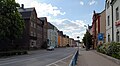
Augustusburger Strasse, the main street through the city

Flöha train station
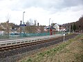
Flöha-Plaue stop (2016)

Bus station

Confluence of the Flöha and Zschopau rivers
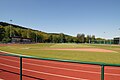
Auenstadion
.jpg)
.jpg)
.JPG)
.jpg)
.jpg)
.jpg)
Personalities
literature
- Georg Dehio : Handbook of the German Art Monuments, Saxony II, administrative districts Leipzig and Chemnitz , Munich 1998, ISBN 3-422-03048-4 , pages 241–243
- The middle Zschopau area (= values of our homeland . Volume 28). 1st edition. Akademie Verlag, Berlin 1977, pp. 62-69.
- Ekkehard Kühnrich: The inhabitants of the parish Flöha (Saxony) 1550-1720. Plaidt: Cardamina 2013, ISBN 978-3-86424-156-7 ; contains Altenhain, Braunsdorf, Falkenau, Flöha, Gückelsberg, Plaue and Bernsdorf
- Bernd Rüdiger: Flöha. From Waldhufendorf to socialist district town , Flöha 1984
- Richard Steche : Flöha. In: Descriptive representation of the older architectural and art monuments of the Kingdom of Saxony. 6th booklet: Amtshauptmannschaft Flöha . CC Meinhold, Dresden 1886, p. 64.
Web links
- Atlas Central Saxony
- List of cultural monuments in Flöha
- Homepage of the city of Flöha
- Wikiprojekt from mein-flöha.de
- Flöha in the Digital Historical Directory of Saxony
- Gückelsberg in the Digital Historical Directory of Saxony
- Plaue in the Digital Historical Directory of Saxony
- Bernsdorf in the Digital Historical Directory of Saxony
Individual evidence
- ↑ Population of the Free State of Saxony by municipalities on December 31, 2019 ( help on this ).
- ^ Karlheinz Blaschke , Uwe Ulrich Jäschke : Kursächsischer Ämteratlas. Leipzig 2009, ISBN 978-3-937386-14-0 ; P. 70 f.
- ^ The Flöha district administration in the municipal register 1900
- ^ Forced labor at Fortuna GmbH in Flöha
- ↑ Altenhain on gov.genealogy.net
- ↑ ( Free Press )
- ↑ Ernst Eichler , Hans Walther (Ed.): Historisches Ortnamesbuch von Sachsen , Berlin 2001, ISBN 3-05-003728-8 , Volume I, page 263
- ^ Ernst Eichler and Hans Walther : Saxony. All city names and their history , Faber and Faber Verlag, Leipzig 2007, ISBN 978-3-86730-038-4 , p. 59f.
- ↑ Karlheinz Blaschke (ed.): Historical local directory of Saxony , new edition, Leipzig 2006, ISBN 3-937209-15-8 , page 221
- ^ Statistisches Reichsamt: General register of municipalities for the German Reich based on the 1939 census. Accessed on January 15, 2019 .
- ↑ [1]
- ^ The Sachsenbuch, Kommunal-Verlag Sachsen KG, Dresden, 1943
- ^ Georg Dehio : Handbuch der Deutschen Kunstdenkmäler, Saxony II, administrative districts Leipzig and Chemnitz , Munich 1998, ISBN 3-422-03048-4 , page 238
- ↑ State Statistical Office of the Free State of Saxony - Local elections 2019, election results Flöha