
Seelitz
| coat of arms | Germany map | |
|---|---|---|

|
Coordinates: 51 ° 2 ′ N , 12 ° 49 ′ E |
|
| Basic data | ||
| State : | Saxony | |
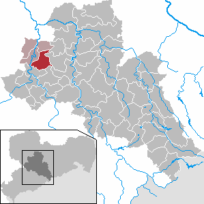
| County : | Central Saxony | |
| Management Community : | Rochlitz | |
| Height : | 224 m above sea level NHN | |
| Area : | 31.22 km 2 | |
| Residents: | 1663 (Dec. 31, 2019) | |
| Population density : | 53 inhabitants per km 2 | |
| Postal code : | 09306 | |
| Primaries : | 03737, 037384 (angles) | |
| License plate : | FG, BED, DL, FLÖ, HC, MW, RL | |
| Community key : | 14 5 22 530 | |
| Community structure: | 24 districts | |
| Address of the municipal administration: |
Mittweidaer Strasse 5 09306 Seelitz |
|
| Website : | ||
| Mayor : | Thomas Oertel (Church Citizens Movement) | |
| Location of the community of Seelitz in the district of central Saxony | ||
  |
||

Seelitz is a municipality in the north of the district of Central Saxony in Saxony . It is part of the Rochlitz administrative community based in the city of the same name.
geography
The community is located about 2 km southeast of the town of Rochlitz and 13 km northwest of the town of Mittweida above the Zwickauer Mulde .
Community structure
In addition to the core town of Seelitz, the following districts belong to the municipality:
history


Local history
Seelitz and the surrounding villages are of Slavic origin. Although there are no written sources that testify to this across the board, you can recognize it e.g. B. on ceramic finds (shards of vessels), the Slavic ramparts such. B. Fischheimer Borstel and Kötterner Porschel , the field and place names and finally on the shape and size of the respective local corridors.
The place was first mentioned in 1174 as Seliz in a deed of donation from the margrave Dedo of Lusatia . In this he donated four Seelitzer Hufen to the Zschillen Monastery, which was founded at the time .
The spelling of the place name has only changed slightly since then.
- 1174: Seliz
- 1205 and 1378: Selicz
- 1489: Zelitcz
- 1548: Selietz
- 1791: Seelitz
The name is of old Sorbian origin. The original meaning cannot be clarified beyond doubt. The personal name Žel is possible as a short form of Želidrog, so Seliz would have been the settlement of a Žel. Another interpretation is based on zel - green, settlement where it is green.
In the Thirty Years' War and later wars, Seelitz suffered from marauding troops and epidemics. From an administrative point of view, Seelitz has belonged to the Rochlitz office since the late Middle Ages . The parish of neighboring villages made it an ecclesiastical center. Regarding the manorial lordship , Seelitz belonged to the Rochlitz council and the parish of Seelitz around 1548 . Around 1764 the place belonged as an official village to the Electoral Saxon or Royal Saxon Office of Rochlitz. A settlement of German emigrants in Missouri , founded in 1839 but only existed for about 2 years, was named after the place.
The offices were dissolved during the administrative reforms carried out in the Kingdom of Saxony in the 19th century . As a result, in 1856 Seelitz came under the administration of the Rochlitz court office and in 1875 under the newly established Rochlitz administration .
By the second district reform in the GDR in 1952 the community was Seelitz the county Rochlitz in the district of Chemnitz (in 1953 the city Karl-Marx-district renamed) attached, which from 1990 Saxon district Rochlitz was continued and in 1994 formed the newly Mittweida or Rose in 2008 in the district of central Saxony. The church concentration in the main town of Seelitz was followed by the administrative one in the 20th century. Due to the gradual incorporation from 1950 onwards, Seelitz now has 24 districts.
Incorporations

| Former parish | date | annotation |
|---|---|---|
| Beedeln | 07/01/1965 | Incorporation to Kolkau |
| Bernsdorf | 05/01/1936 | Incorporation after Beedeln |
| Biesern | 07/01/1950 | Incorporation to Steudten |
| Döhlen | 03/01/1969 | |
| Fischheim | 07/01/1950 | Incorporation to Steudten |
| Groblitz | 07/01/1950 | |
| Groebschütz | 03/01/1974 | |
| Big cities | 04/01/1935 | Amalgamation with small towns to form cities |
| Small towns | 04/01/1935 | Amalgamation with large cities to form cities |
| Kolkau | 04/01/1993 | |
| Kolkau, manor district | around 1922 | Incorporation to Kolkau |
| Köttern | 07/01/1950 | Incorporation to Spernsdorf |
| Neudörfchen | before 1875 | Incorporation after Döhlen |
| Neutaubenheim , manor district | around 1922 | Incorporation after Döhlen |
| Neuwerder | before 1875 | Incorporation after Döhlen |
| Brushing | 07/01/1950 | |
| Seebitzschen | 07/01/1950 | Incorporation to Steudten |
| Sordid | 07/01/1950 | Incorporation to Steudten |
| Spernsdorf | 04/01/1993 | |
| Cities | 07/01/1950 | Incorporation to Zetteritz |
| Steudten | 01/01/1994 | |
| Angles | 01.03.1963 01.01.1994 |
Incorporation to Zschoppelshain, reclassification to Seelitz |
| Zetteritz | 01/01/1994 | |
| Zetteritz, manor district | around 1922 | Incorporation to Zetteritz |
| Zollnitz | 04/01/1935 | Incorporation to Seebitzschen |
| Zschaagwitz (with Neuzschaagwitz) | 07/01/1950 | Incorporation to Spernsdorf |
| Zschauitz | 07/01/1950 | Incorporation to Gröbschütz |
Church history
According to the "Meißnische Chronika", the history of the Seelitz Church is said to go back to the 8th century.
The parish of Seelitz arose around 1000 and was assigned to the diocese of Meißen after the land around Rochlitz had been taken over by the Germans who came to the area from Franconia . By this time the entire Sorbian population had been baptized and formally accepted the Christian faith. Violent incidents in connection with proselytizing are not known in our region.
Reliable are the dates 1516 and 1529 carved in stone on the village church of St. Annen itself. According to Dehio , the current building was erected as a late Gothic hall church in place of a Romanesque church that could have been built in the 11th century.
Around 1430, Seelitz was hit by the Hussite invasion , and the church was also destroyed. Seelitz joined the Reformation relatively early . The school that was established in Seelitz in 1527 was probably already Protestant. Seelitz developed as a certain ecclesiastical center of the surrounding villages. Today, Seelitz is the largest parish in Saxony with 23 towns.
From 1769 to 1771 the church was led by the re Auer master carpenter Michael default in a baroque Emporensaal rebuilt. The furnishings with altar, pulpit (both 1770/71) and Rococo baptism (1773) were created by the sculptor Johann Gottfried Stecher (1718–1776), who was based in Penig at the time .

St. Anne's Church around 1840
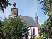
St. Anne's Church 2012
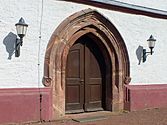
Gothic door frame

inside view


politics
Municipal council
Since the municipal council election on May 25, 2014 , the 14 seats of the municipal council have been distributed among the individual groups as follows:
- Citizens' Movement Church (BBW): 8 seats
- Bürgergemeinschaft FFw (BG FFw): 3 seats
- LEFT : 2 seats
- CDU : 1 seat
mayor
In June 2015, Mayor Thomas Oertel was confirmed in office with 97.3% of the votes.

Culture and sights
- see also: List of cultural monuments in Seelitz
- St. Anne's village church
- Rochlitz mountain
- Muldental with the Sörnzig – Fischheim suspension bridge
- Fischheimer Borstel , Slavic ramparts around 1000
- Biesern sand pit, swimming and fishing waters
traffic
The B 107 (Rochlitz – Chemnitz) runs through the east of the municipality and the B 175 also runs in the north of the municipality (Rochlitz – Geringswalde). The Glauchau – Wurzen (“Muldentalbahn”) railway that runs through the Steudten district is no longer in operation, and the Waldheim – Rochlitz railway that runs through the Döhlen district has also been closed. A reactivation of the route is currently under political discussion. Seelitz is on the Mulderadweg .

Steudten station (2016)
Döhlen stop (2016)
.JPG)
.JPG)
literature
- William Clemens Pfau : Basic features of the older history of the village of Seelitz and its church. Publishing house Bode, 1902.
- New Saxon Church Gallery. Volume: The parish of Seelitz. Verlag Strauch, Leipzig 1909. (digitized version)
- Richard Steche : Seelitz. In: Descriptive representation of the older architectural and art monuments of the Kingdom of Saxony. 14th booklet: Amtshauptmannschaft Rochlitz . CC Meinhold, Dresden 1890, p. 90.
Web links
- Atlas Central Saxony
- Official website of the community of Seelitz
- Seelitz in the Digital Historical Directory of Saxony
- Chronicle of the Seelitz Church
Individual evidence
- ↑ Population of the Free State of Saxony by municipalities on December 31, 2019 ( help on this ).
- ↑ a b Seelitz in the Digital Historical Directory of Saxony
- ↑ Ernst Eichler , Hans Walther (ed.): Historisches Ortnamesbuch von Sachsen , Berlin 2001, ISBN 3-05-003728-8 , Volume II, p. 402
- ^ Karlheinz Blaschke , Uwe Ulrich Jäschke : Kursächsischer Ämteratlas. Leipzig 2009, ISBN 978-3-937386-14-0 ; P. 58 f.
- ^ The State Historical Society of Missouri: Perry County Place Names . Retrieved September 25, 2015.
- ^ The Rochlitz district administration in the municipal register 1900
- ↑ a b c d e f g h i j k l m n Federal Statistical Office (Ed.): Municipalities 1994 and their changes since 01.01.1948 in the new federal states. Metzler-Poeschel publishing house, Stuttgart 1995, ISBN 3-8246-0321-7 .
- ↑ a b c d The Saxony Book. Municipal publishing house Saxony, Dresden 1943.
- ↑ a b c d e f g h i j Ministry of the Interior of Saxony (ed.): Lists of the municipalities that have been incorporated since May 1945 and evidence of the breakdown of the independent manor districts and state forest districts. 1952.
- ↑ a b c d e State Statistical Office of the Free State of Saxony: Area changes.
- ↑ a b Statistical Bureau of the Royal Ministry of the Interior (ed.): Directory of municipalities and places for the Kingdom of Saxony. 1904.
- ↑ Seelitz, its church and its villages. Part II . In: Rochlitzer Anzeiger , May 2, 2013, p. 38. Archived from the original on September 4, 2014. (digitized)
- ↑ a b Parish of Seelitz. In: Church Gallery of Saxony, The Inspections Penig, Rochlitz, Colditz and Waldheim. Dresden 1843, p. 189 (digitized version)
- ↑ Chronicle of the Seelitz Church
- ^ Karlheinz Blaschke : History of Saxony in the Middle Ages. Berlin 1991, ISBN 3-372-00076-5 , p. 66.
- ↑ Richard Steche : Seelitz. In: Descriptive representation of the older architectural and art monuments of the Kingdom of Saxony. 14th booklet: Amtshauptmannschaft Rochlitz . CC Meinhold, Dresden 1890, p. 90.
- ^ Georg Dehio : Handbook of German Art Monuments, Saxony II, administrative districts of Leipzig and Chemnitz. Munich 1998, ISBN 3-422-03048-4 , p. 911.
- ^ Church chronicle Seelitz
- ↑ Results of the 2014 municipal council elections
Beedeln | Bernsdorf | Biesern | Döhlen | Fischheim | Groeblitz | Groebschütz | Kolkau | Köttern | Neudörfchen | Neuwerder | Neuzschaagwitz | Brushing | Seebitzschen | Seelitz | Sörnzig | Spernsdorf | Cities | Steudten | Angles | Zetteritz | Zöllnitz | Zschaagwitz | Zschauitz