
Oberschöna
| coat of arms | Germany map | |
|---|---|---|
 Help on coat of arms |
Coordinates: 50 ° 54 ' N , 13 ° 15' E |
|
| Basic data | ||
| State : | Saxony | |
| County : | Central Saxony | |
| Height : | 370 m above sea level NHN | |
| Area : | 44.29 km 2 | |
| Residents: | 3265 (Dec. 31, 2019) | |
| Population density : | 74 inhabitants per km 2 | |
| Postal code : | 09600 | |
| Primaries : | 037321, 03731 , 037207 , 037328 | |
| License plate : | FG, BED, DL, FLÖ, HC, MW, RL | |
| Community key : | 14 5 22 430 | |
| LOCODE : | DE OSO | |
| Community structure: | 6 districts | |
| Address of the municipal administration: |
At Hauptstrasse 10 09600 Oberschöna |
|
| Website : | ||
| Mayor : | Rico Gerhardt ( CDU ) | |
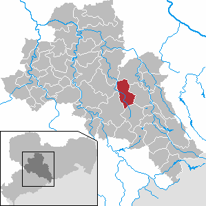
| Location of the municipality Oberschöna in the district of central Saxony | ||
  |
||

Oberschöna is a municipality in the central Saxony district in Saxony , which has been merged since January 1, 1997 , and consists of five villages and a railway settlement . The association of municipalities emerged from a municipal agricultural council, or from 1973 from the municipal administration association "An der Striegis", which included Bräunsdorf , Kleinschirma , Langhennersdorf , Oberschöna and Wegefarth as well as the Kleinwaltersdorf district , which is now part of Freiberg .
Local division
Oberschöna consists of the following parts of the municipality:
Districts:
- Bräunsdorf (with Zechendorf)
- Small business
- Langhennersdorf
- Oberschöna
- Wegefarth
Railroad settlement
- Frankenstein station (in the Wegefarth district)
geography
location
The Waldhufendorf Oberschöna is located in the Eastern Ore Mountains , 6 km west of Freiberg , 6 km north of Brand-Erbisdorf and 30 km east of Chemnitz at an altitude of 350 m to 390 m above sea level . The community is located in the valley of the Great Striegis . The federal highway 173 leads through the village , a state road leads to Brand-Erbisdorf.
Neighboring places
| Striegistal | Large company | |
| Hainichen |
.svg)
|
Freiberg |
| Oederan | Brand-Erbisdorf |
The district of Oberschöna borders in the west on the Bahnhof Frankenstein settlement, in the north on the district Wegefarth, in the west on the district Kleinschirma, in the southwest on the Brand-Erbisdorf districts St. Michaelis and Linda and in the southeast on the Oederaner district Kirchbach .
history


Oberschöna was first mentioned in 1183. In a document from 1185, in which the boundaries of the eastern possessions of the Altzella monastery are described, the four Eckhard villages are also commemorated. These were fiefdoms of the Hersfeld monastery in Hessen . It was later concluded that Oberschöna, Linda , but also Wegefarth and probably St. Michaelis belonged to these villages.
Since 1445/1447 there was a knight's seat or Vorwerk in Oberschöna , which was called a manor since 1551 . This was owned by the von Schönberg family from the 14th century to 1761 , after which it was owned by the governor von Gersdorff until 1771 , and then by the von Carlowitz family until at least 1860 . In addition to Oberschöna, the towns of Oberreichenbach and Kirchbach belonged to the manor estate of Oberschöna . The town of Hainichen and the villages of Wingendorf and Frankenstein were also subordinate to the Oberschöna manor until the 16th century , but later they came under the rule of the Wingendorf manor .
After the secularization of the Altzella monastery in the 16th century until 1856, Oberschöna was part of the Freiberg district office of the Electoral Saxon or Royal Saxon district . From 1856 the place belonged to the Freiberg judicial office and from 1875 to the Freiberg district administration . After the Second World War, the manor house of the manor Oberschöna was demolished. A farm building has been preserved to this day.
As a result of the second district reform in the GDR , Oberschöna came to the Freiberg district in the Chemnitz district in 1952 (renamed the Karl-Marx-Stadt district in 1953 ), which was continued as the Saxon district of Freiberg from 1990 and was added to the district of Central Saxony in 2008.
Incorporations
| Former parish | date | annotation |
|---|---|---|
| Bräunsdorf | 03/01/1994 | Merger with Langhennersdorf to Bräunsdorf-Langhennersdorf |
| Bräunsdorf-Langhennersdorf | 01/01/1997 | |
| Small business | 01/01/1994 | |
| Langhennersdorf | 03/01/1994 | Merger with Bräunsdorf to become Bräunsdorf-Langhennersdorf |
| Oberschöna, manor district | around 1922 | |
| Wegefarth | 07/01/1950 |
Population development
The following population figures in the municipality of Oberschöna refer to December 31 of the previous year with the territorial status January 2007:
|
1982 to 1988
|
1989 to 1995
|
1996 to 2002
|
2003 to 2013
|

- Source: State Statistical Office of the Free State of Saxony
politics
Municipal council
Since the municipal council election on May 25, 2014 , the 18 seats of the municipal council have been distributed among the individual groups as follows:
mayor
Rico Gerhardt (CDU) was elected to succeed Helmut Zönnchen (CDU) in June 2015.
Culture and sights
- see also: List of cultural monuments in Oberschöna
traffic
- Langhennersdorf airfield in Langhennersdorf
- Railway line Dresden – Werdau with stops in Frankenstein (Sachs) and Kleinschirma (part of the Sachsen-Franken-Magistrale )
- The Nossen – Moldau railway runs 1.5 km through the Langhennersdorf district, the next connection is at Kleinwaltersdorf station
- There is a connection to the federal highway 101 via a large company
- Federal highway 173 crosses Oberschöna
- State road 203 crosses Frankenstein station and ends in Oberschöna
- State road 205 crosses Bräunsdorf
- State road 206 begins in Oberschöna
- the next motorway connection, to the federal motorway 4 , is in Berbersdorf (5.5 km)

Frankenstein (Sachs) station (2016)

Partial view of the Kleinschirma stop (2016)
.JPG)
.JPG)
Personalities
- Eduard Stein (1818–1864), conductor and royal court music director of Schwarzburg-Sondershausen
- Wilhelm Poller (1860–1935), police chief and politician
- Philipp von Wegefarth , landlord, historically verifiable legendary figure
- Herbert Ehrlich (1932–2019), engineer and professor for control engineering
- Bernd Silbermann (* 1941), mathematician, born in Langhennersdorf
Personalities who have worked on site
- Adolf Gottlieb Fiedler (1771–1850), entrepreneur in Saxony and Poland
- Romanus Teller (1703–1750), theologian and university professor
- Hans Heinrich von Crostewitz
- Elsa Asenijeff (1867–1941), writer
See also
literature
- Georg Dehio (Ed.): Handbook of German Art Monuments, Bd. Sachsen II, administrative region Leipzig and Chemnitz ; 2nd Edition; German art book publisher; Berlin 1998, ISBN 3-422-03048-4 , pp. 755f
- Freiberger Land (= values of our homeland . Volume 47). 1st edition. Akademie Verlag, Berlin 1988.
- M. Koch (Ed.): 777 years of Kleinschirma 1224–2001 ; Media center of the TU Bergakademie; Freiberg 2001; 66 pp.
- AH Königsdörffer: Devastation of the Langhennerdorf church tour near Freiberg in the Thirty Years' War and its restoration ; Freiberg 1879
- GA Poenicke, F. Heise: Album of the castles and manors in the Kgr. Saxony. Vol. IV Erzgebirge District; Knightly album association; Leipzig 1856; 224 pp.
- JG Preußer, M. Kaupisch: Langhennersdorf with Bräunsdorf, Reichenbach and Seifersdorf. in: Saxony's church gallery. 1 vol .; Schmidt Verlag; Dresden 1838; Pp. 197-202
- A. Sauer, A. Rothpletz: Explanations of the geological special map of the Kgr. Saxony - Section Freiberg-Langhennersdorf, sheet 79 ; Engelmann Verlag; Leipzig 1887; 60 p. 6
- O. Voigt: The Langhennersdorf Parish. in: G. Buchwald (Ed.): New Saxon Church Gallery. Ephorie Freiberg; Strauch Verlag; Leipzig 1900; Pp. 299-324
- Richard Witzsch: Between Chemnitz and Freiberg. Vol. II The villages on the Striegis; Roßberg Verlag; Frankenberg 1929; Striegistal 2012
- Richard Steche : Oberschöna. In: Descriptive representation of the older architectural and art monuments of the Kingdom of Saxony. 3. Issue: Amtshauptmannschaft Freiberg . CC Meinhold, Dresden 1884, p. 114.
Individual evidence
- ↑ Population of the Free State of Saxony by municipalities on December 31, 2019 ( help on this ).
- ^ StBA: Changes in the municipalities, see 1997
- ↑ Oberschöna on www.burgen-und-schloesser.net
- ^ Karlheinz Blaschke , Uwe Ulrich Jäschke : Kursächsischer Ämteratlas. Leipzig 2009, ISBN 978-3-937386-14-0 ; P. 72 f.
- ^ The Amtshauptmannschaft Freiberg in the municipality register 1900
- ↑ The manor Oberschöna on www.sachsens-schloesser.de
- ↑ a b c d State Statistical Office of the Free State of Saxony: Area changes
- ↑ Municipalities 1994 and their changes since January 1, 1948 in the new federal states , Metzler-Poeschel publishing house, Stuttgart, 1995, ISBN 3-8246-0321-7 , publisher: Federal Statistical Office
- ↑ Directories of the municipalities incorporated since May 1945 and evidence of the breakdown of the independent manor districts and state forest districts, 1952, publisher: Ministry of the Interior of Saxony
- ↑ Results of the 2014 municipal council elections
Web links
- Atlas Central Saxony
- official website of the municipality of Oberschöna
- Oberschöna in the Digital Historical Directory of Saxony
- Natura2000 protected area Striegistäler