
Langhennersdorf airfield
| Langhennersdorf airfield | |||
|---|---|---|---|
|
|||
| Characteristics | |||
| ICAO code | EDOH | ||
| Coordinates | |||
| Height above MSL | 386 m (1266 ft ) | ||
| Transport links | |||
| Distance from the city center | 1 km southwest of Langhennersdorf | ||
| Basic data | |||
| opening | 1996 | ||
| operator | FC Langhennersdorf eV | ||
| Flight movements |
1600 landings (2012) | ||
| Start-and runway | |||
| 05/23 | 900 m × 40 m grass | ||

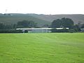
The airfield Langhennersdorf is a special airfield in the area of Saxon community Oberschona at Freiberg ( mittelsachsen ) supported by the resident Luftsportverein is used and operated.

Runway

Runway

Runway
Aircraft hangar


history
The site is a former agricultural airfield . After the fall of the Wall , the area was initially used by the Langhennersdorf Flieger Club with an outside take-off permit, before the permit as a special landing site was granted in 1996 .
Web links
- edoh.de - Flieger-Club Langhennersdorf eV
- eddh.de - another site with information from EDOH airfield
|
Auerbach • Bautzen • Böhlen • Chemnitz-Jahnsdorf • Görlitz • Grossenhain • Großrückerswalde • Kamenz • Klix • Langhennersdorf • Nardt • Oschatz • Pirna-Pratzschwitz • Roitzschjora • Riesa-Göhlis • Rothenburg / Görlitz • Taucha • Torgau-Beilrode • Zwickau |
||