
Neck bridge
| coat of arms | Germany map | |
|---|---|---|

|
Coordinates: 50 ° 57 ' N , 13 ° 21' E |
|
| Basic data | ||
| State : | Saxony | |
| County : | Central Saxony | |
| Height : | 350 m above sea level NHN | |
| Area : | 41.04 km 2 | |
| Residents: | 5057 (Dec. 31, 2019) | |
| Population density : | 123 inhabitants per km 2 | |
| Postal code : | 09633 | |
| Primaries : | 03731, 037324, 035209 | |
| License plate : | FG, BED, DL, FLÖ, HC, MW, RL | |
| Community key : | 14 5 22 240 | |
| LOCODE : | DE HKK | |
| Community structure: | 10 districts | |
| Address of the municipal administration: |
At Ernst-Thälmann-Heim 1 09633 Halsbrücke |
|
| Website : | ||
| Mayor : | Andreas Beger ( CDU ) | |
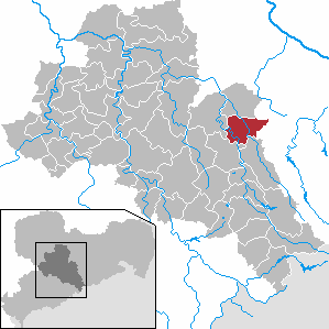
| Location of the municipality of Halsbrücke in the district of central Saxony | ||
  |
||


Halsbrücke is a municipality in the district of Central Saxony .
geography
Halsbrücke is located 5 km north of Freiberg on the left bank of the Freiberger Mulde , which describes a larger river bend here. The place has a north-south extension of about one kilometer and an east-west extension of about two kilometers. The lowest point is about 296 m above sea level. NN and the highest point at about 375 m above sea level. NN.
The Halsbrücke district of the municipality of the same name includes, in addition to Halsbrücke, the districts of Hals and Neubau on the left bank of the Freiberger Mulde, as well as Sand with Grüneburg on the right bank of the Freiberg Mulde.
Neighboring communities
Neighboring communities are Bobritzsch-Hilbersdorf , Freiberg, Großschirma and Reinsberg (all in the district of Central Saxony) and Wilsdruff and Tharandt in the district of Saxon Switzerland-Eastern Ore Mountains .
Community structure
The following districts belong to the municipality of Halsbrücke:
- Conradsdorf with the municipal parts of Kleinsiebenlehn, Hinterhäuser and Gegentrum
- Enlightened
- Falkenberg
- Haida
- Halsbrücke with the municipal parts of Neubau, Sand, Grüneburg and Hals
- Hetzdorf with its districts Wüsthetzdorf, Neuwüsthetzdorf, Hutha, Herrndorf
- Krummenhennersdorf with part of the community forest houses
- Niederschöna
- Oberschaar
- Tuttendorf
history

The island property in the loan book of Margrave Friedrich III. Vorwerk and later Kanzleilehngut "zcu dem Halse ", first designated by Meißen in 1349, was located on the southern "neck-shaped" back of the large hollow loop northwest of the village. The "Hals" estate originally belonged to the Altzella monastery , and since the 16th century it has belonged to the city of Freiberg.
In the later place names czu der brucken am Hals (1441), an der Halßbrücken (1654), Halßbrücke (1706) the former Muldenbrücke above the current road bridge is included. Around 1791, Halsbrücke was referred to as a mountain spot. The new construction of the Vorwerk , built around 1600 in the area of the Hals manor , was inherited , which was originally called Pudewitzsches Vorwerk .
The former district of Sand (1778 aufn Sande , 1796/1804 the village of Sand ) on the other bank of the Freiberg Mulde was built at the end of the 17th century on the Erlerschen Gut , which belonged to the Krummenhennersdorf manor . The small settlement Grüneburg belonged to Sand .
The Freiberg Mulde formed the border between two sovereign administrative districts in the area from Halsbrücke until the 19th century. Halsbrücke and the outlying works of Hals and Neubau on the left bank of the Freiberg Mulde were located in the Freiberg district office of the Electorate of Saxony and the royal Saxon district until 1856 . Sand and Grüneburg on the right bank of the Freiberger Mulde, on the other hand, belonged to the Meißen district office until 1836 , only then were they also attached to the Freiberg district office. In 1856, Halsbrücke and Sand came to the Freiberg judicial office and, after the judiciary and administration were separated, in 1875 to the Freiberg district administration . In 1933, Sand was incorporated into Halsbrücke.
Halsbrücke did not have its own church. The place was parish to Tuttendorf. The church of St. Lorenz am Schulberg in Halsbrücke was built from 1985 to 1991 and consecrated in 1992. From 1890 to 1975, Halsbrücke was the terminus of the Freiberg – Halsbrücke branch line .
As a result of the second district reform in the GDR , the municipality of Halsbrücke became part of the Freiberg district in the Chemnitz district (renamed the Karl-Marx-Stadt district in 1953 ), which was continued as the Saxon district of Freiberg from 1990 and was added to the district of Central Saxony in 2008.
Mining and smelting
The for Freiberger Revier scoring mining and smelting are closely linked to the history of neck bridge. The first mention of a pit was in 1519 St. Lazarus near the neck house . In 1612, the St. Lorenz and Rheinischer Wein mines opened their own trade union works, from which the Halsbrück smelter emerged in 1663 . The south wing of the electoral amalgamation plant , which was newly built after a fire from 1792 to 1794, is still there.
Wilhelm August Lampadius built the first European light gas facility in the Halsbrücke smelter in 1815 . A lead factory was established in 1853, a gold refinery in 1862 and a sulfuric acid factory in 1865. For the planning to relocate the Dresden Mint , the Halsbrücker Hütten was proposed as a new location towards the end of the 19th century. The hut management pointed out that "a second grinding mill had recently been bought by the state, which had sufficient hydropower and Halsbrücke offers everything that both places (powder mill in Dresden-Löbtau and Muldenhütten ) can barely offer together." The government decided however, opted for the planned Muldenhütten mint .
The Halsbrücker Esse , built in 1888/98, with a smoke duct to discharge the smoke gases from the Halsbrücker smelting works, known as the “Hohe Esse” of Halsbrücke's landmark, was once the highest chimney in the world.
In 1709 the union "Halsbrücker Vereinigt Feld" was created by merging the main mines (closed in 1746). In 1861, the “re-attack of the underground works on the Halsbrücker Spat” began with the Erbstolln mine, which delivered 7171 kg of silver from 1874 to its closure in 1900. It was put back into operation in 1935. The last use was in 1968.
The slag dump "Hohe Esse", also known as the cable car dump, was built in 1917 because the valley of the Mulde was no longer sufficient to transport the slag from the lead smelter in Halsbrück. Up to 285,000 tons of lead slag are stored here.
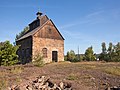
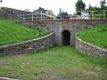
The 8th light hole of the Rothschönberger Stolln with a drifthouse for a steam conveyor system, built in 1872, and the Kaue of the Stolln from 1865 are located to the west on the hollow slope. The greenhouse was completely rebuilt in 1990. The chew of the 8th light hole is still original. The 7th light hole of the tunnel is about 800 m west of it. The plant was in operation from 1844 to 1876. The above-ground facilities of the 7th light hole are the mining forge and the powder house built in 1844, the greenhouse built in 1850 as well as parts of the ditch and partially exposed wheelhouses.

Drifthouse - 8th light hole

Chew - 8th light hole

Bergschmiede - 7th light hole
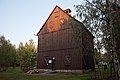
Greenhouse - 7th light hole

Pulverhaus - 7th light hole
Drifthouse of the "Oberes Neues Geschrei" pit

Upper new clamor, historical
Entrance to the 500 m long smoke channel of the Hohen Esse at the Pochwerkhalde in the middle of the village

Zinc cover, neck bridge, pit aid


The Rothschönberger Stolln, built from 1844 to 1877, with its branches over 50 km long, was the most important water management work of Freiberg mining for the drainage of mine water.
The Rote Graben , built around 1613, is the most famous artificial moat . It served to supply impact water for the operation of the hut , the laundry and the art and sweeping wheels . The washing of the Oberes Neues Geschrei pit, with wheel chamber and exposed artificial moat, was built around 1840.
In 1788, Johann Friedrich Mende built a boat lift to lift ore barges along the Churprinzer Bergwerkskanal , which is believed to be the oldest ship lift in the world. The boat lift house was closed in 1868.

Former underwear
View from the Erzwlauch to the Hohe Esse

Structural remnants of the Halsbrücke smelter
Hut (1977)


In 1945 the VEB Bleihütte and in 1961 the VEB Bergbau und Hüttenkombinat "Albert Funk" were founded, from which in 1990 the SAXONIA AG Metallhütten- und Processingwerke Freiberg emerged.
Incorporations
| Former parish | date | annotation |
|---|---|---|
| Conradsdorf | March 1, 1994 | |
| Enlightened | before 1875 | Incorporation to Herrndorf |
| Falkenberg | July 1, 1950 | Incorporation to Conradsdorf |
| Hals, manor | around 1922 | |
| Herrndorf | April 1, 1948 | Incorporation to Hetzdorf |
| Hetzdorf | March 1, 1994 | Incorporation to Niederschöna |
| Hutha | before 1875 | Incorporation to Herrndorf |
| Krummenhennersdorf | March 1, 1994 | |
| Krummenhennersdorf, manor district | around 1922 | Incorporation to Krummenhennersdorf |
| New building, manor district | around 1922 | |
| Niederschöna | January 1, 2006 | |
| Niederschöna, manor district | around 1922 | Incorporation to Niederschöna |
| Oberschaar (with Haida) | July 1, 1950 | Incorporation to Niederschöna |
| Oberschaar, manor district | around 1922 | Incorporation to Oberschaar |
| Sand (with Grüneburg) | September 1, 1933 | |
| Tuttendorf | July 1, 1950 | Incorporation to Conradsdorf |
| Wüsthetzdorf | January 1, 1887 | Incorporation to Hetzdorf |
Population development
As of December 31st:
|
1786 to 1925
|
1939 to 2000
|
Development of the population from 1982 (December 31st) with territorial status January 2007:
|
1982 to 1988
|
1989 to 1995
|
1996 to 2002
|
2003 to 2013
|
- Source: State Statistical Office of the Free State of Saxony
In 1933, Sand was incorporated into Halsbrücke. In 1994 the merger with Conradsdorf and Krummenhennersdorf to form the rural community of Halsbrücke. On January 1, 2006, Niederschöna was incorporated, as a result of which the municipality of Niederschöna and its districts Hetzdorf, Oberschaar, Haida and Erlicht became districts of the municipality of Halsbrücke.
Memorials
- Tombs in the cemetery of the local part Conradsdorf for four unknown concentration camp prisoners , the case of a death march to the satellite camp of Leipzig and Colditz Buchenwald concentration camp in April 1945 by SS men were killed
- Graves in the same cemetery for two Wehrmacht soldiers , one of whom is known by name, who were murdered for desertion in April 1945
- Grave site, memorial stone and sculpture "The Sufferer" by the sculptor Harald Stephan from 1976 in the cemetery in the district of Krummenhennersdorf in memory of 16 murdered concentration camp inmates
- Tombs and wooden crosses in the cemetery of the local part Niederschöna commemorating an unknown Jewish girl from a prisoner transport from Glogau and to the Polish forced laborers Stanislaw Gutiparz, both victims of forced labor were
Culture and sights

Halsbrücke is known for its ore smelting , non-ferrous and precious metallurgy and the formerly tallest chimney in the world, built in 1888/1889 , the so-called "Hohe Esse" with a height of 140 m. The chimney was built with awareness of environmental pollution with the aim of discharging toxic smoke gases into higher air layers. There are several technical monuments in the former industrial complex . In addition, there is a former barge hoist of the historic mining industry in the Freiberg mining area , which is probably the first ship lift in the world, as well as the Altväter Bridge , the parallel construction of an aqueduct built around 1685 and blown up in 1893, and light holes in the Rothschönberger Stolln . Various metallurgical technologies were practiced and further developed in Halsbrücke. The best known method is the extraction of gold using the amalgamation process .
politics
Municipal council
The 16 seats of the municipal council are distributed as follows:
(As of: local elections on May 25, 2014 )
mayor
The 22-year term of office of Mayor Jörg Kiehne (CDU) ended in August 2012. In June 2012, Andreas Beger was elected as his successor with 96.3% of the vote.
Coat of arms, flag, official seal
coat of arms
|
|
Blazon : “Split in silver over a green shield base with three arched openings, in front a roofed green house with three arched black window openings and two roof turrets on top of each other, crossed with black mallets with iron ; behind a ring-shaped, stepped green chimney on a plinth with an arched black opening and a green rod protruding to the side of the gap, a black hut-tooth attached to the gap (scraper, fork and chisel). "
The coat of arms was designed in 2012 by the municipal heraldist Jörg Mantzsch . It shows the eponymous bridge, the "Hohe Esse" (the landmark of Halsbrücke) with a smoke gas duct and the hothouse of the pit "Oberes Neues Geschrei " with the mining and hut symbols. The coat of arms has been valid in this version since 2012. |
flag

Description: “The flag of Halsbrücke is a two-striped flag, the left (mast-side) stripes are green and the right stripes are white on the longitudinally striped flag (1: 1). With the stripe flag, the top stripe is green and the bottom stripe is white (1: 1). The coat of arms is placed in the middle. "
Official seal
The official coat of arms can be found in the official seal of Halsbrücke .
Economy and Infrastructure
The community has two industrial areas: the "Schwarze Kiefern" industrial area in the Tuttendorf district and the "Zu den Linden" industrial area in the Niederschöna district on the B 173 near the milk cattle facility of the Niederschöna agricultural cooperative.
Important companies in Halsbrücke are SAXONIA Holding GmbH (recovery of precious metals and manufacture of precious metal products), SAXONIA Galvanik GmbH and SAXONIA EuroCoin GmbH (manufacture of blanks for coins and medals). Feinhütte Halsbrücke GmbH specializes mainly in the production of alloys made from tin, lead and antimony. Freiberg Silicium- und Targetverarbeitung GmbH in Halsbrücke, district of Tuttendorf, manufactures targets and molded parts from silicon.
The "Klinik am Tharandter Wald" - rehabilitation clinic for orthopedics, trauma surgery, neurology, cardiology / internal medicine has been located in the Hetzdorf district since 1997. The solar-heated leisure and adventure pool “Sumpfmühle”, which opened in 1995, is also located here.
Educational institutions
There are two primary schools in the municipality of Halsbrücke, one in Halsbrücke and one in Niederschöna. The secondary school is located in the Halsbrücke district. The SAXONIA-BILDUNG Gemeinnützige Bildungsgesellschaft mbH in Halsbrücke mainly offers initial training, retraining and further education. The districts of Halsbrücke, Tuttendorf and Niederschöna have a day-care center. A library is located in the districts of Conradsdorf, Halsbrücke, Hetzdorf and Niederschöna.
traffic
.jpg)
The municipality of Halsbrücke is connected supraregionally to the B 101 and B 173 and is easily accessible from both Dresden and Freiberg. The districts of the municipality are connected to the public transport network.
The line from Freiberg , opened in 1890, has been closed since 1995, the next station is now Freiberg train station .
societies
The local sports club is VfB Saxonia Halsbrücke. In addition to football, the club also offers volleyball, athletics and gymnastics.
Personalities
- Albrecht I, the Proud (* 1158; † June 24, 1195 in Krummenhennersdorf), Margrave of Meissen
- Johann Friedrich Henckel (born August 1, 1678 in Merseburg, † January 26, 1744 in Freiberg), doctor, mineralogist, metallurgist and chemist, initiated the cinder bath in Halsbrücke, worked on mountain addiction (tuberculosis) and the hut cat (lead disease)
- Christlieb Ehregott Gellert (born August 11, 1713 in Hainichen, † May 18, 1795 in Freiberg), metallurgist and mineralogist, introduction of the European barrel algamating of silver ores at the Halsbrücker Hütte
- Johann Christian Fischer (* around 1733 in Conradsdorf or Freiburg im Breisgau; † April 29, 1800 in London), composer and oboist
- Johann Friedrich Mende (born October 3, 1743 in Lebusa; † July 1, 1798 in Freiberg), mechanical engineer, built what is probably the world's oldest ship lift in Halsbrücke to lift ore barges
- Wilhelm August Lampadius (born August 8, 1772 in Hehlen, † April 13, 1842 in Freiberg), metallurgical engineer, chemist and agronomist, built the first European light gas facility in Halsbrücke in 1815
- Ferdinand Reich (born February 19, 1799 in Bernburg, † April 27, 1882 in Freiberg), chemist and physicist, researches on smelter - apparatus for the determination of sulfuric acid gases in the air
- Carl Eduard Schubert (born October 31, 1830 in Halsbrücke, † January 11, 1900 in Reichenbach in the Vogtland), organ builder
- Richard Ulbricht (born September 9, 1834 in Tuttendorf; † February 10, 1907 in Loschwitz), agricultural chemist
- Eugen Käferstein (born January 6, 1835 in Crimmitschau, † November 9, 1875 in Conradsdorf), manor owner and conservative politician
- Alfred Lange (born January 18, 1906 in Halsbrücke, † February 26, 1968 in Freiberg), metallurgist
literature
- Freiberger Land (= values of our homeland . Volume 47). 1st edition. Akademie Verlag, Berlin 1988.
- Neck . In: August Schumann : Complete State, Post and Newspaper Lexicon of Saxony. 3rd volume. Schumann, Zwickau 1816, p. 673 f.
- Grueneberg . In: August Schumann : Complete State, Post and Newspaper Lexicon of Saxony. 3rd volume. Schumann, Zwickau 1816, p. 595.
- Sand . In: August Schumann : Complete State, Post and Newspaper Lexicon of Saxony. 10th volume. Schumann, Zwickau 1823, p. 160 f.
- Heinz Schlegel (Ed.): 350 years of the Halsbrücke Hut, 1612-1962. Chronicle of the history of the Halsbrücke hut from its origins to the present . Halsbrücke hut, 1962.
- Neck bridge. On the history of the community, mining and smelting. Edited by the municipality of Halsbrücke on the occasion of the anniversary “400 years of the Halsbrücke smelter site”. Halsbrücke, 2012. ISBN 978-3-86012-435-2
Web links
- Atlas Central Saxony
- official website of the municipality of Halsbrücke
- Halsbrücke in the Digital Historical Directory of Saxony
- 40133 Hut Halsbrücke in the Freiberg mountain archive
- Land estate in the main state archive in Dresden
- VEB Bergbau- und Hüttenkombinat Albert Funk including predecessor companies and successors in the Freiberg mountain archive
- Halsbrücke church, built 1985–1991 (Freiberg church district)
- Halsbrücke municipal coat of arms in the Free Press
Individual evidence
- ↑ Population of the Free State of Saxony by municipalities on December 31, 2019 ( help on this ).
- ^ Neck in the Digital Historical Directory of Saxony
- ↑ The manor Hals in the "Handbuch der Geographie", p. 612
- ↑ The Hals Rittergut at www.sachsens-schloesser.de
- ^ New building in the Digital Historical Directory of Saxony
- ↑ Grüneburg in the "Handbuch der Geographie", pp. 611f.
- ^ Karlheinz Blaschke , Uwe Ulrich Jäschke : Kursächsischer Ämteratlas. Leipzig 2009, ISBN 978-3-937386-14-0 ; P. 72 f.
- ^ Sand with Grüneburg as a place in the Freiberg district office, book "Handbuch der Geographie", p. 638f.
- ^ The Amtshauptmannschaft Freiberg in the municipality register 1900
- ↑ Sand on gov.genealogy.net
- ^ Otfried Wagenbreth , Eberhard Wächtler (ed.) A. Becke et al .: Der Freiberg mining. Technical monuments and history . Deutscher Verlag für Grundstofftindustrie, Leipzig, 1986, p. 254
- ^ Max Barduleck: The last years of the mint in Dresden . Catalog of works 1865 to 1911, edited by Paul Arnold, Berlin 1981, p. 51
- ↑ Plate 15 - 8th light hole from Rothschönberger Stolln ( Memento from January 9, 2012 in the Internet Archive )
- ↑ Plate 14 - 7th light hole from Rothschönberger Stolln ( Memento from January 9, 2012 in the Internet Archive )
- ↑ a b c d State Statistical Office of the Free State of Saxony: Area changes
- ^ A b c Directory of parishes and places for the Kingdom of Saxony, 1904, publisher: Statistical Bureau of the Royal Ministry of the Interior
- ↑ a b c d municipalities 1994 and their changes since 01.01.1948 in the new federal states , Metzler-Poeschel publishing house, Stuttgart, 1995, ISBN 3-8246-0321-7 , publisher: Federal Statistical Office
- ↑ a b c d lists of the municipalities incorporated since May 1945 and evidence of the subdivision of the independent manor districts and state forest districts, 1952, publisher: Ministry of the Interior of Saxony
- ↑ a b Das Sachsenbuch, Kommunal-Verlag Sachsen KG, Dresden, 1943
- ↑ cf. Halsbrücke in the Digital Historical Directory of Saxony
- ↑ StBA: Changes in the municipalities in Germany, see 2006
- ↑ Municipal council election 2014, municipality of Halsbrücke, district of central Saxony
- ↑ http://www.cdu-sachsen.de/inhalte/2/aktuelles/28235/-erverkauf-buergermeisterwahlen-in-bernsdorf-und-halsbruecke-/index.html
- ↑ a b Halsbrücker Anzeiger No. 6, p. 3, June 20, 2012