
Oberschaar (neck bridge)
|
Oberschaar
Halsbrücke parish
|
||
|---|---|---|
 |
||
| Height : | 331 m above sea level NN | |
| Incorporation : | July 1, 1950 | |
| Incorporated into: | Niederschöna | |
| Postal code : | 09633 | |
| Area code : | 035209 | |
Location of Oberschaar in Saxony |
||


Oberschaar is a district of the municipality of Halsbrücke in the district of central Saxony . He was incorporated on July 1, 1950 to Niederschöna and with this on January 1, 2006 to Halsbrücke.
geography
Location and traffic
The village is about 12 km northeast of the district town Freiberg in the floodplain of the Rodelandbach, a right-hand tributary of the Bobritzsch at about 331 m above sea level. NN. The district is connected to the local public transport network and can be easily reached nationwide via the B 173, both from Freiberg and from Dresden .
Neighboring places
| Reinsberg | Dittmannsdorf | |
| Krummenhennersdorf |
.svg)
|
Haida |
| Niederschöna | Enlightened |
history
_Herrenhaus.jpg)
The former Waldhufendorf was first mentioned in 1378 under the name Dobirschow and Dobirschar as the property of the Burgraves of Meissen . The place name indicates a piece of mine field located between two mine boundaries, which did not correspond to the size of a mining measure (Übersaar, Oberschaar). In 1418 it is called Obirschar , 1445 Owernschar , 1566 Oberschar and 1791 Ober Schaar .
The sovereign administrative districts of the village were the castrum Freiberg in 1378 and from 1548 to 1856 the electoral Saxon or royal Saxon district office Freiberg , whose northeastern tip was formed by the place with Haida. In 1856 the place became part of the Freiberg judicial office and, after the judiciary and administration were separated, in 1875 it became part of the Freiberg administration . The manorial rule was in 1548 with the council of Freiberg. In 1606 it was made a manor , which existed until at least 1875. From 1500 the place was parish after Krummenhennersdorf . Oberschaar has been part of the Niederschöna-Oberschaar parish since 1940.
Until 1807 ore mining was carried out in various mines on Oberschaarer Flur. A reference to this is contained in the place name, which is also a mining term. The pits on Oberschaarer Flur were:
- So-Gott-Will-Erbstolln, 1709–1716
- Segen-Gottes-Erbstolln, 1774–1787
- Goldene-Aue-Erbstolln, 1787
- Jacob Erbstolln, 1789–1791
- Ludwig-Erbstolln, 1806/1807
Of the half-timbered houses in the village, the building erected as an inn in the 17th century is particularly representative. The inn was changed around 1830 and renovated in 1993 as the "Gasthof Oberschaar" community center. The street-side gable shows beautiful half-timbering with St. Andrew's crosses . The former inn is known as one of the oldest inns in Saxony.
On July 1, 1950 Oberschaar was with town section of Haida to Niederschöna incorporated. In 1952 the agricultural production cooperative (LPG) "Drei Linden" was founded. The agriculturally used areas are now part of the plant production of the agricultural cooperative Niederschöna. Three mills once worked in Oberschaar, the Obermühle, the Mittelmühle and the Niedermühle. The Niedermühle was still in operation around 1950. Between 1923 and 1971 the place had a breakpoint on the narrow-gauge railway Klingenberg-Colmnitz-Oberdittmannsdorf . Today there is a cycling and hiking trail along the route.
As a result of the second district reform in the GDR , Oberschaar became part of the municipality of Niederschöna in 1952 and became part of the Freiberg district in the Chemnitz district (renamed the Karl-Marx-Stadt district in 1953 ), which was continued as the Freiberg district of Saxony from 1990 and became part of the district in 2008 Central Saxony rose. With the incorporation of the community of Niederschöna to Halsbrücke, Oberschaar became a district of Halsbrücke on January 1, 2006.
Oberschaar Church
_Dorfkirche.jpg)
The exact age of the small medieval village church of St. Catherine is not known. The remarkable altar painting from 1662 is an old copy after Anthonis van Dyck . The baptismal font is decorated with the coat of arms of the Freiberg patrician family Alnpeck , who were the landlords here in the 16th century. In 2007 the roof structure and the belfry were renewed and a second bell could be consecrated.
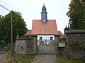
Entrance to the churchyard
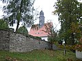
The church with the medieval surrounding wall

Obelisk-like monument to the dead of the First World War


Development of the population
1548: 22 possessed men , 41 inhabitants , 18 hooves ; 1764 10 possessed men, 10 gardeners, 13 hooves, 12 bushels each .
As of December 31st :
|
1834 to 1910
|
1925 to 1946
|
The only district was Haida before Oberschaar was incorporated into Niederschöna in 1950 . On January 1, 2006, the community of Niederschöna was incorporated with the districts after Halsbrücke. Oberschaar consequently became a district of Halsbrücke.
literature
- Freiberger Land (= values of our homeland . Volume 47). 1st edition. Akademie Verlag, Berlin 1988.
- Richard Steche : Oberschaar. In: Descriptive representation of the older architectural and art monuments of the Kingdom of Saxony. 3. Issue: Amtshauptmannschaft Freiberg . CC Meinhold, Dresden 1884, p. 113.
Web links
- Oberschaar in the Digital Historical Directory of Saxony
- Manorial rule Oberschaar in the main state archive in Dresden
- Neck bridge online ; therein: Oberschaar
- Freiberg church district - Niederschöna-Oberschaar parish ; therein: Oberschaar Church
Individual evidence
- ↑ Freiberger Land (= values of our homeland . Volume 47). 1st edition. Akademie Verlag, Berlin 1988 p. 82
- ^ Karlheinz Blaschke , Uwe Ulrich Jäschke : Kursächsischer Ämteratlas. Leipzig 2009, ISBN 978-3-937386-14-0 ; P. 72 f.
- ^ The Amtshauptmannschaft Freiberg in the municipality register 1900
- ↑ The manor Oberschaar on www.sachsens-schloesser.de
- ↑ Freiberger Land (= values of our homeland . Volume 47). 1st edition. Akademie Verlag, Berlin 1988 p. 83
- ↑ Oberschaar on gov.genealogy.net
- ↑ Niederschöna on gov.genealogy.net
- ^ Oberschaar in the Digital Historical Directory of Saxony