
Hartha
| coat of arms | Germany map | |
|---|---|---|

|
Coordinates: 51 ° 6 ′ N , 12 ° 59 ′ E |
|
| Basic data | ||
| State : | Saxony | |
| County : | Central Saxony | |
| Height : | 269 m above sea level NHN | |
| Area : | 54.4 km 2 | |
| Residents: | 6949 (Dec. 31, 2019) | |
| Population density : | 128 inhabitants per km 2 | |
| Postal code : | 04746 | |
| Area code : | 034328 | |
| License plate : | FG, BED, DL, FLÖ, HC, MW, RL | |
| Community key : | 14 5 22 250 | |
City administration address : |
Karl-Marx-Strasse 32 04746 Hartha |
|
| Website : | ||
| Mayor : | Ronald Kunze (independent) | |
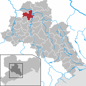
| Location of the city of Hartha in the district of central Saxony | ||
  |
||

Hartha is a small town in Saxony (Germany) and is located in the district of central Saxony .
geography
It includes the districts of Aschershain, Diedenhain, Wallbach, Wendishain, Nauhain, Lauschka , Steina, Saalbach, Richzenhain and Flemmingen as well as Gersdorf, which was incorporated in 2004, with its districts of Langenau, Kieselbach, Neudörfchen, Schönerstädt and Seifersdorf. This makes Hartha one of the largest municipalities in the district.
Neighboring communities are (starting in the north clockwise) Leisnig , Großweitzschen , Döbeln , Waldheim , Geringswalde (all in central Saxony) and in the west Colditz in the district of Leipzig .
A large part of this area is still used for agriculture today.
The city of Hartha is centrally located in the triangle of the large cities Leipzig - Dresden - Chemnitz with a distance of about 50 km and acts as a sub-center for the surrounding area.
Hartha is located in the central Saxon hill country . The highest point is the Harthaer Kreuz at 326 m above sea level. NN . This is where the B 175 , B 176 and S 36 cross .
history
The first documentary mention dates back to the year 1223. Heinrich von Harth and his brother Albert von Gersdorf are mentioned in a document that was issued in Altenberg by King Heinrich (VII) as a witness to a legal dispute. Gersdorf is the current name of a larger district of Hartha.

Hartha was founded near a traffic route between Dresden and Leipzig. Around 1100 salt was transported on this route from the Halle area to Bohemia . The ancestors of the Harthaer come from Franconia , Thuringia and Flanders .
Hartha's reputation as an industrial city goes back to the first half of the 16th century. In 1506, the guild of linen weavers was confirmed by Duke Georg of Saxony . The textile products manufactured here were exported to Spain as early as 1750 . In addition to the textile industry , agriculture played an important role.
In the district of Gersdorf on Bundesstrasse 176, a memorial stone commemorates the battle near Gersdorf on May 5, 1813 .
In the middle of the 19th century, a number of factories were set up, mainly producing felt , shoes and metal articles ( braid ) for weaving , but also cigars and buttons . Was known the coach factory of MJ Plenikowski & Co . This helped the city to an economic upswing.
Historical place name forms
The following spellings can be found in certificates:
- 1223: Heinricus de Hart (indirect mention)
- 1404: the steady in the hard
- 1445/1447: Stetchen die Harthe
- 1590: Hartta
- 1791: Hartha
The name is derived from the Middle High German word hart for forest, woody mountain range, so Hartha is a settlement on a (mountain) forest.
Incorporations
| Former parish | date | annotation |
|---|---|---|
| Ash Grove | 07/01/1950 | |
| Diedenhain | 07/01/1950 | |
| Flemmingen | 01/01/1914 | |
| Gersdorf | 01/01/2004 | |
| Kieselbach | 01/01/1969 | Incorporation to Gersdorf |
| Langenau | 01/01/1993 | Incorporation to Gersdorf |
| Lauschka | 02/01/1936 | Incorporation to Wendishain |
| Nauhain | 07/01/1950 | Incorporation to Wendishain |
| Neudörfchen | 01/01/1952 | Incorporation to Kieselbach |
| Reinhardtsthal | 1862 | |
| Richzenhain | 06/01/1905 | Partial incorporation, part incorporated into Waldheim |
| Saalbach | 07/01/1950 | Incorporation to Steina |
| Schönerstädt | 01/01/1978 | Incorporation to Gersdorf |
| Seifersdorf | 01/01/1968 | Incorporation to Schönerstädt |
| Steina | 01/01/1994 | |
| Wallbach | 01/01/1969 | |
| Wendishain | 01/01/1994 |
politics
Municipal council
Since the municipal council election on May 25, 2014 , the 18 seats of the municipal council have been distributed among the individual groups as follows:
economy
Hartha was and is the location of numerous commercial enterprises. In the years up to 1945, the shoe and textile manufacturing sectors as well as food manufacturers were influential; later Hartha became a center for the manufacture of automotive parts, textile machine construction and electrical engineering. The products included u. a. Electric motors, shock absorbers, slippers and woven goods such as the "Harthaer Schottenstoffe" with checked patterns. The construction and printing industries were also represented by numerous companies.
Hartha is also currently a popular industrial location. Small, medium-sized and larger companies in the following branches of industry are active in Hartha: mining and processing of stones and earth, electrical engineering, production of automotive parts, metalworking and processing (including in the field of electroplating, casting technology, mechanical engineering), plastics processing, construction, logistics , Printing, and wholesale and retail. In addition, numerous companies in the trade, the hotel and hospitality industry as well as cultural companies with supraregional appeal (Hartharena venue) are located.
In addition, there are numerous agricultural and livestock farms and facilities for energy generation (water power, wind power) in the area around the city.
Culture and sights
church
When one speaks of the Harthaer Church, then the fourth church building is meant. The first church burned down in 1506. The second fell victim to the flames of the Thirty Years' War. The third, built in 1636, was angular and unadorned, uneven and irregular; this testified to the poverty of old Hartha. The foundation stone of the fourth church was laid in 1868 after King Johann had encouraged the community in their desire for a new building during a visit by Hartha in 1861 and a tour of the old church. The building plans for the new church come from the builder Emil Haase from Chemnitz. On November 13, 1870, the city church in Hartha was inaugurated. Due to its architectural beauty in the neo-Romanesque style, it is still an ornament of the city today. Since 1910 it has had an organ which, with 45 sounding registers, is the largest in the whole ephoria . The leaded glass windows date from 1892.
Observatory
The Bruno-H.-Bürgel observatory on Töpelstraße was built step by step from 1954 and is the home of the Sternwarte Hartha e. V. , which organizes an annual observer meeting of the Federal German Working Group for Variable Stars . The observatory has an extensive data collection on the subject of variable stars , which after extensive digitization of the photo plates comprises a data volume of 752 GB (2006).
More Attractions
- Hartha is nicknamed Frosch-Hartha . There used to be a few ponds in the urban area that were populated by frogs. The frogs were the inspiration for the frog fountain inaugurated on May 11, 1996 on the market square.
- Three viaducts of the bankruptcy mile are located in the districts of Saalbach and Steina.
- Memorial stone in the city park at Reinhardtstal for all victims of fascism
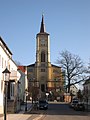
City Church

Hartha market square
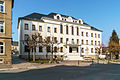
town hall
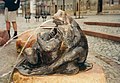
Frog fountain in the market square
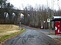
Steinaer railway viaduct


Town twinning
After the political turning point in 1989, Hartha became friends with the city of Fröndenberg / Ruhr / in the Unna district ( North Rhine-Westphalia ). A friendship contract was signed on June 1, 1991, after contacts and friendly relationships had existed since 1990.
Personalities
- Karl Grünberg (1847–1906), woven goods manufacturer in Hartha and politician (SPD), Member of the Bundestag, Member of the Bundestag (Kingdom of Saxony)
- August Harder (1775–1813), musician, song composer, born and raised in the Schönerstädt district
- Werner Heilemann (* 1925), former German politician
- Max Jahn (1881–1954) civil servant, politician (SPD) and mayor of Bremen
- Hans Jahn (1885–1960), SPD politician , trade unionist and resistance fighter against National Socialism
- Bernhard Moebius (1851–1898), German-American metallurgist and inventor
- Alfred Teichmann (1903–1980), painter
- Richard Müller (1903–1999), chemist, discoverer of silicone, Müller-Rochow synthesis
- Kurt Männer (1913–1942), footballer, top scorer of the Tschammer Cup in 1937
- Osmar Spitzner (1924–1969), university professor, member of the People's Chamber
traffic
The most important roads in the area of the municipality are the federal highway 175 , which touches the city of Hartha on its northern edge, the federal highway 176 , which joins the previous one at the Harthaer Kreuz in a roundabout, and the state highway 36 , which is a few meters east of it in one Another roundabout crosses the federal highway 175 and touches the urban area of Hartha on the southwest side.
The station Hartha (Kr chub) is located at the Waldheim-Rochlitz railway . This line has been closed since 1998. In the east of the municipality, the Steina stop is located on the Chemnitz-Riesa railway line, about 2.5 km from the eponymous district and 5 km from the city center of Hartha.
There are daily bus connections to Rochlitz , Waldheim , Leisnig , and Döbeln , on weekdays also to Colditz and some smaller towns and free transfers to Geithain . Hartha is in the tariff area of the Central Saxony transport association , in the transitional traffic from and to the Central German Transport Association its tariff applies.

Hartha station (Kr Döbeln), track side, 2016

Hartha station (Kr Döbeln), street side, 2016

Hartha station (Kr Döbeln) with vegetation on the site, 2016

Entrance to the station from the direction of Waldheim, 2016
_(2).JPG)
_(3).JPG)
_(1).JPG)
_Bahnhofseinfahrt_aus_Richtung_Waldheim.JPG)
literature
- Cornelius Gurlitt : Hartha. In: Descriptive representation of the older architectural and art monuments of the Kingdom of Saxony. 25th booklet: Office governance Döbeln . CC Meinhold, Dresden 1903, p. 79.
- A tradition of the Hartha City Court for the period 1620–1852 on court and local administration, criminal, civil and voluntary jurisdiction, court books and court records is in the Saxon State Archives, State Archives Leipzig, inventory 20608 City Hartha (City Court).
Web links
- Atlas Central Saxony
- official website of the city of Hartha
- Hartha in the Digital Historical Directory of Saxony
- official website of the Hartha Astronomy Association
Individual evidence
- ↑ Population of the Free State of Saxony by municipalities on December 31, 2019 ( help on this ).
- ↑ Ernst Eichler , Hans Walther (Ed.): Historisches Ortnamesbuch von Sachsen , Berlin 2001, ISBN 3-05-003728-8 , Volume I, pages 389 and 378
- ↑ a b c d e f g h i municipalities 1994 and their changes since 01.01.1948 in the new federal states , Metzler-Poeschel publishing house, Stuttgart, 1995, ISBN 3-8246-0321-7 , publisher: Federal Statistical Office
- ↑ a b c The Saxony Book, Kommunal-Verlag Sachsen KG, Dresden, 1943
- ↑ a b c d State Statistical Office of the Free State of Saxony: Area changes
- ↑ Reinhardtsthal in the Digital Historical Directory of Saxony
- ↑ Results of the 2014 municipal council elections
- ↑ Invitation for 2019
- ↑ Internet presence of the Hartha observatory
- ^ City of Hartha (City Court). In: State Archives Leipzig. Retrieved March 26, 2020 . (Info text on Hartha City Court under "Introduction")
Ash Grove | Diedenhain | Flemmingen | Gersdorf with Langenau , Kieselbach , Neudörfchen , Schönerstädt and Seifersdorf | Lauschka | Nauhain | Richzenhain | Saalbach | Steina | Wallbach | Wendishain