
Lichtenau (Saxony)
| coat of arms | Germany map | |
|---|---|---|

|
Coordinates: 50 ° 54 ' N , 13 ° 0' E |
|
| Basic data | ||
| State : | Saxony | |
| County : | Central Saxony | |
| Height : | 349 m above sea level NHN | |
| Area : | 49.15 km 2 | |
| Residents: | 7076 (Dec. 31, 2019) | |
| Population density : | 144 inhabitants per km 2 | |
| Postal code : | 09244 | |
| Primaries : | 037206, 037208 | |
| License plate : | FG, BED, DL, FLÖ, HC, MW, RL | |
| Community key : | 14 5 22 330 | |
| Community structure: | 8 districts | |
| Address of the municipal administration: |
Auerswalder Hauptstrasse 2 09244 Lichtenau |
|
| Website : | ||
| Mayor : | Andreas Graf ( CDU ) | |
| Location of the municipality of Lichtenau in the district of central Saxony | ||
  |
||

Lichtenau is a municipality in the district of Central Saxony ( Saxony ).
geography
In the south, Lichtenau borders on the city of Chemnitz . In the west the Chemnitz river and in the east the Zschopau represent the municipality boundary.
Local division
The municipality comprises a total of eight districts:
history

The villages in the municipality have German place names. This and the common division of the corridors into hoofs suggests that the villages were founded in the 12th century during the medieval eastern settlement .
History of the place name
The originally independent municipalities Nieder- and Oberlichtenau give it its name. Both villages were first mentioned in the document book of Friedrich des Strengen in 1350 .
Origin and incorporations
On January 1, 1994, the municipalities of Niederlichtenau and Oberlichtenau were merged to form the first municipality of Lichtenau. Five years later, on January 1st, 1999, it merged with the formerly independent towns of Auerswalde and Ottendorf to form a new municipality, which initially bore the name Auerswalde. On September 11, 2000, it was renamed Lichtenau.
| Former parish or manor district | date | annotation |
|---|---|---|
| Auerswalde | January 1, 1999 September 11, 2000 |
Merger with Lichtenau and Ottendorf zu Auerswalde, renamed Lichtenau |
| Biensdorf | before 1875 | Incorporation to Krumbach |
| Garnsdorf | January 1, 1994 | Incorporation to Auerswalde |
| Krumbach | October 1, 1994 | Incorporation to Ottendorf |
| Lichtenau | January 1, 1999 | Merger with Auerswalde and Ottendorf zu Auerswalde |
| Merzdorf | January 1, 1967 | Incorporation to Niederlichtenau |
| Niederlichtenau | January 1, 1994 | Merger with Oberlichtenau to Lichtenau |
| Oberlichtenau | January 1, 1994 | Merger with Niederlichtenau to Lichtenau |
| Ottendorf | January 1, 1999 | Merger with Auerswalde and Lichtenau to Auerswalde |
| Frankenberg state forest district, manor district | December 11, 1948 | Partial integration to Krumbach |
| Frankenberg state forest district, manor district | June 12, 1948 | Partial integration to Merzdorf in the course of the land reform |
politics
Mayor of the municipality has been Andreas Graf since November 3, 2014.
The council elected in 2019 is composed as follows:
| Political party | Seats |
|---|---|
| Free voters | 6th |
| CDU | 5 |
| AfD | 3 |
| THE LEFT | 2 |
| Green | 1 |
There is a town partnership with the Bavarian town of Neustadt am Kulm .
Economy and Infrastructure
traffic
Lichtenau is located just off the motorway Chemnitz- Dresden ( A 4 ) and has a connection point ( "Chemnitz-Ost") and the motorway service area "Auerswalder view". Federal highway 169 runs south of the village .
The community is connected to the railway network via the Riesa – Chemnitz railway and has stations in the districts of Oberlichtenau and Ottendorf, from which the ChemnitzBahn runs to Mittweida and downtown Chemnitz. The regional trains of the Mitteldeutsche Regiobahn also stop at the edge of the day . A third station ( Auerswalde-Köthensdorf ) is located on the disused Chemnitz Valley Railway from Chemnitz to Wechselburg .
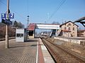
Oberlichtenau station (2016)
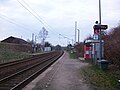
Hp. Ottendorf b Mittweida (2016)

.JPG)
Local businesses
religion
In Niederlichtenau, Ottendorf and Auerswalde there is an Evangelical Lutheran church, each of which belongs to a different church district (Marienberg, Glauchau-Rochlitz or Chemnitz) of the Evangelical Lutheran regional church of Saxony . There is also a regional church community in Auerswalde and Merzdorf .
education
_(1).jpg)
The municipality of Lichtenau has three primary schools in Niederlichtenau, Ottendorf and Auerswalde, as well as a high school in Oberlichtenau.
Culture and sights
- see also: List of cultural monuments in Lichtenau
.jpg)
- Sonnenland - Lichtenau Adventure Park, u. a. with ferris wheel, indoor playground, Germany's highest slide tower, wave flyer, climbing paradise and petting zoo
Personalities
- David Hoyer (1667–1720), painter, born in Auerswalde
- Carl Gottlieb Haubold (1783–1856), entrepreneur, is considered the "father of Chemnitz mechanical engineering", born in Auerswalde
- Kurt Barthel (1914–1967), writer, poet, playwright and dramaturge, born in Garnsdorf
- Angelika Klein (* 1951), politician (Die Linke), born in Garnsdorf
Web links
- Atlas Central Saxony
- official website of the municipality of Lichtenau
- Lichtenau in the Digital Historical Directory of Saxony
Individual evidence
- ↑ Population of the Free State of Saxony by municipalities on December 31, 2019 ( help on this ).
- ↑ Ernst Eichler , Hans Walther (ed.): Historisches Ortnamesbuch von Sachsen , Berlin 2001, Volume I, p. 591, ISBN 3-05-003728-8 .
- ↑ a b c d e f g State Statistical Office of the Free State of Saxony: Area changes
- ↑ Community and place directory for the Kingdom of Saxony, 1904, publisher: Statistical Bureau of the Royal Ministry of the Interior
- ↑ Municipalities 1994 and their changes since January 1, 1948 in the new federal states , Metzler-Poeschel publishing house, Stuttgart, 1995, ISBN 3-8246-0321-7 , publisher: Federal Statistical Office
- ^ A b Ministry of the Interior of the State of Saxony (ed.): Lists of the municipalities incorporated since May 1945 and evidence of the breakdown of the independent manor districts and state forest districts. 1952.
- ↑ a b Municipal council election 2019: Election results for the municipal council elections Saxony. Retrieved May 27, 2019 .