
Chemnitz (river)
| Chemnitz | ||
.png) |
||
| Data | ||
| Water code | EN : 5418 | |
| location | Saxony , Germany | |
| River system | Elbe | |
| Drain over | Zwickauer Mulde → Mulde → Elbe → North Sea | |
| source | through the confluence of the Zwönitz and Würschnitz rivers in Chemnitz 50 ° 47 ′ 23 ″ N , 12 ° 55 ′ 26 ″ E |
|
| Source height | 313.1 m above sea level NHN | |
| muzzle | near Wechselburg in the Zwickauer Mulde Coordinates: 50 ° 59 ′ 15 ″ N , 12 ° 46 ′ 28 ″ E 50 ° 59 ′ 15 ″ N , 12 ° 46 ′ 28 ″ E |
|
| Mouth height | approx. 168 m above sea level NHN | |
| Height difference | approx. 145.1 m | |
| Bottom slope | approx. 1.9 ‰ | |
| length | 76.5 km (with Zwönitz , of which 37.0 as Chemnitz ) | |
| Catchment area | 533 km² | |
| Discharge at the Göritzhain A Eo gauge : 532 km² Location: 1.2 km above the mouth |
NNQ (08/13/1911) MNQ 1910–2014 MQ 1910–2014 Mq 1910–2014 MHQ 1910–2014 HHQ (06/02/2013) |
200 l / s 1.63 m³ / s 6.37 m³ / s 12 l / (s km²) 72.9 m³ / s 257 m³ / s |
 The Chemnitz River in the Chemnitz district of Altchemnitz |
||
The (from Sorbian von Kamenica , German Steinbach ) is a right and the most important tributary of the Zwickauer Mulde and namesake of the Saxon town of the same name .
course

The Chemnitz arises from the confluence of the Würschnitz (Hügelbach) and the larger Zwönitz (Zvonica - sounding brook) in the south of the city of Chemnitz (in the Altchemnitz district ) and runs parallel to Annaberger Straße to the city center (Falkeplatz). The Chemnitz then flows west past the Brühl and then leaves the city of Chemnitz in the Chemnitz Valley through the districts of Furth and Draisdorf near the Schützenwald forest.
Within the urban area, the Chemnitz is fed by several creeks that run both above ground (e.g. Kappelbach, Pleißenbach , Bahrebach) and underground (e.g. Bernsbach, Gablenzbach ). In addition, the Glösbach, the Wittgensdorfer Bach, the Auerswalder Bach, the Holzbach, the Röllingshainer Bach, the Voselsbach, the Mohsbach, the Pfaffenschluchtbach, the Kalte Bach and the Wiederbach flow into the Chemnitz.
The river leaves the city in the north and flows past Taura . A little below the valley narrows like a gorge to form several rocky ridges in the so-called Schweizerthal . Here the Chemnitz forms wild water stretches rich in blocks with a high gradient. Two kilometers south of Wechselburg , the Chemnitz flows into the Zwickauer Mulde, which also flows in a very narrow valley here . In the 19th century in particular, the Chemnitz supplied hydropower for local craft and industrial companies.
From Furth to Taura the federal road 107 accompanies the river on the right bank, from there the state road S 240 to Mohsdorf on the left, then to Göritzhain on the right bank. From Furth to the estuary, the Chemnitz Valley Railway, which was closed at the end of 2002, followed the valley of the river, but changed banks several times. The Chemnitz Valley Cycle Path now runs on or next to the former route.
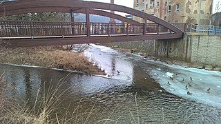
Confluence of Zwönitz (left) and Würschnitz (right) to Chemnitz on March 3, 2018.

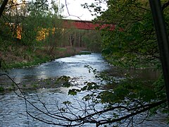
Chemnitz river near Schweizerthal

Chemnitz flood in Chemnitz-Furth (January 1932)
Chemnitz estuary with the Muldentalbahn bridge near Wechselburg (2016)

.JPG)


literature
- Steffen Kluttig, Ronny Preußler, Achim Poller: Along the rails from Chemnitz to Wechselburg - the Chemnitz Valley and its railroad . Bildverlag Böttger, Witzschdorf 2nd extended edition 2005, ISBN 3-9808250-2-7
- Heimatverein Köthensdorf e. V .: Chemnitztal story (s) - historical considerations between Chemnitz and Wechselburg . Bildverlag Böttger, Witzschdorf 2006, ISBN 3-937496-16-5
See also
Web links
- Roland Mischke: Under 54 Bridges (Die Zeit, 35/1995)
- From Chemnitz to the sea
Individual evidence
- ↑ Topographic map 1: 25,000
- ^ German Hydrological Yearbook Elbe Region, Part I 2014. (PDF) State Office for Flood Protection and Water Management Saxony-Anhalt, p. 137 , accessed on November 3, 2018 (from: lhw.sachsen-anhalt.de).