Zwönitz (river)
| Zwönitz | ||
|
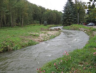
Zwönitz north of Thalheim |
||
| Data | ||
| Water code | DE : 54181 | |
| location | Saxony , Germany | |
| River system | Elbe | |
| Drain over | Chemnitz → Zwickauer Mulde → Mulde → Elbe → North Sea | |
| Headwaters | at Schatzenstein 50 ° 36 ′ 9 ″ N , 12 ° 51 ′ 30 ″ E |
|
| Source height | approx. 645 m above sea level NHN | |
| muzzle | Maps Chemnitz-Altchemnitz together with the Würschnitz the river Chemnitz . Coordinates: 50 ° 47 ′ 23 " N , 12 ° 55 ′ 26" E 50 ° 47 ′ 23 " N , 12 ° 55 ′ 26" E |
|
| Mouth height | 313.1 m above sea level NHN | |
| Height difference | approx. 331.9 m | |
| Bottom slope | approx. 8.5 ‰ | |
| length | 39.2 km | |
| Catchment area | 144 km² | |
| Discharge at the Burkhardtsdorf gauge 2 A Eo : 93.04 km² Location: 18.6 km above the mouth |
NNQ (08/26/2003) MNQ 1992/2010 MQ 1992/2010 Mq 1992/2010 MHQ 1992/2010 HHQ (08/13/2002) |
107 l / s 269 l / s 1.48 m³ / s 15.9 l / (s km²) 25.5 m³ / s 77 m³ / s |
| Discharge at the Altchemnitz gauge 1 A Eo : 143.52 km² Location: 300 m above the mouth |
NNQ (11/04/1994) MNQ 1985/2010 MQ 1985/2010 Mq 1985/2010 MHQ 1985/2010 HHQ (08/13/2002) |
70 l / s 381 l / s 2.18 m³ / s 15.2 l / (s km²) 28.9 m³ / s 110 m³ / s |
| Left tributaries | Berbisdorfer Bach, Wurzelbach, Brünloser Bach, Niederer Halsbach, Oberer Halsbach, Kühnhaider Bach | |
| Right tributaries | Grenzbach, Rachel, Stadtguttalbach with the Einsiedel dam , Kemtauer Bach, Wetzlochbach, Gornsdorfer Bach | |
| Big cities | Chemnitz | |
| Small towns | Zwönitz , Thalheim | |
| Communities | Burkhardtsdorf | |
| Residents in the catchment area | approx. 40,000 | |
|
Tributaries and hydraulic structures
|
||||||||||||||||||||||||||||||||||||||||||||||||||||||||||||||||||
The Zwönitz (from the Sorbian Zvonica - die Klingende ) or Zwönitzbach is the 39 km long, eastern source river of the Chemnitz in Saxony , Germany .
course
The river has its source in the Ore Mountains , on the southwestern edge of the Geyerschen Platte between the Schatzenstein and the Upper Kutten. Their main sources are between 640 and 660 m. ü. NN. between the towns of Zwönitz and Elterlein . On the northern slope of the Black Stone and on the western edge of the Geyers forest, smaller spring arms reach even higher, up to a maximum of 730 m. A Zwönitz spring set in stone is located south of Burgstädtel . The 39.2 km long Zwönitz runs in a northerly direction through the cities of Zwönitz and Thalheim until it merges with the Würschnitz in the Chemnitz district of Altchemnitz and from there forms the Chemnitz river .
Its catchment area is 144 km², its gradient around 350 m. As a watercourse in the middle and lower mountain ranges, the Zwönitz has a simple water regime. Their mean discharge is relatively high due to the influence of the high rainfall Geyers plate. For the place Zwönitz 0.41 m³ / s, after the confluence of the Gornsdorfer Bach 1.12 m³ / s and near the Zwönitz estuary 2.14 m³ / s (Altchemnitz level 1) are given.
The upper Zwönitztal, which runs at right angles to the mountain roof up to Kemtau, suggests an old system that dates back to the time before the Erzgebirgsscholle was raised. The valley line is also the continuation of the direction of flow of the Zwickauer Mulde above the Talknick near Aue .
Others
From the confluence of the Gornsdorfer Bach to the confluence with the Würschnitz , the river is a first-order body of water according to the Saxon Water Act.
The Zwönitz is the longer source river of the Chemnitz, which is around 15 percent richer in water. Until the 16th century it was referred to as Chemnitz throughout its course .
literature
- Between Mülsengrund, Stollberg and Zwönitztal (= values of our homeland . Volume 35). 1st edition. Akademie Verlag, Berlin 1981.
Individual evidence
- ↑ a b c Between Zwickauer Mulde and Geyerschem Wald (= values of our homeland . Volume 31). 1st edition. Akademie Verlag, Berlin 1978, p. 52.
- ↑ Hydrological Handbook. (PDF; 637 kB) Part 3 - Main aquatic values. Free State of Saxony - State Office for Environment and Geology, p. 83 , accessed on December 25, 2017 .
- ↑ Flood protection in 2002 in the Mulde area, Saxon State Office for Environment, Agriculture and Geology; 2009 (pdf)

