
Leubsdorf (Saxony)
| coat of arms | Germany map | |
|---|---|---|
.png)
|
Coordinates: 50 ° 48 ' N , 13 ° 10' E |
|
| Basic data | ||
| State : | Saxony | |
| County : | Central Saxony | |
| Height : | 396 m above sea level NHN | |
| Area : | 34.47 km 2 | |
| Residents: | 3298 (Dec. 31, 2019) | |
| Population density : | 96 inhabitants per km 2 | |
| Postal code : | 09573 | |
| Area code : | 037291 | |
| License plate : | FG, BED, DL, FLÖ, HC, MW, RL | |
| Community key : | 14 5 22 320 | |
| Community structure: | 4 districts | |
| Website : | ||
| Mayor : | Dirk Fröhlich ( CDU ) | |
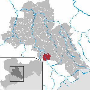
| Location of the community Leubsdorf in the district of central Saxony | ||
  |
||

Leubsdorf is a municipality in the district of central Saxony in Saxony .
geography
.jpg)
Geographical location
Leubsdorf lies with its districts Leubsdorf, Marbach, Schellenberg and Hohenfichte along the Flöhatal at the foot of the Ore Mountains . All districts are Waldhufendörfer . In the east of the Flöhatal is the main town Leubsdorf. To the west of the river are Schellenberg and Marbach. The Hohenfichte district is located directly in the Flöhatal in the north of the municipality.
At 514 meters, the highest point in the municipality is the same height as Augustusburg .
Neighboring communities
| Oederan | ||
| Augustusburg |
.svg)
|
Eppendorf |
| Grünhainichen |
Local division
- Hohenfichte with Metzdorf
- Leubsdorf
- Marbach
- Schellenberg (until November 5, 1919: village of Schellenberg )
history
The places Leubsdorf, Schellenberg, Marbach and the district of Metzdorf von Hohenfichte were created as Waldhufendörfer in the course of the eastern colonization between 1150 and 1200. All places are in the so-called Hersfelder Lehn. Feudal lords of the Hersfeld monastery were the lords of Mildenstein, who are said to have had their seat near Frankenberg. It can be proven that Leubsdorf and Metzdorf were owned by those of Luppelsdorf, since Schellenberg (Dorfschellenberg) is not listed in the feudal book of Friedrich des Strengen from 1378 and Marbach has recently been registered as bought by Wilhelm the One-Eyed. It can be assumed with certainty that these villages were also owned by the Luppelsdorfers. Hohenfichte is only mentioned around 1560, but according to the documents it is likely to be directly related to the seat of the Luppelsdorfers, which is specified in the Lohe, a wooded area between Schellenberg and Hohenfichte.
In Leubsdorf am Rhein, a family from Luppisdorp or Luppsdorf is mentioned. Heinrich is mentioned as a first name. The name Heinrich can also be found several times among the Luppelsdorfer. Luppelsdorf is also mentioned at the Mildenfurth monastery . It can be assumed that these are the same sex. In 1505 the Luppelsdorfers sold the village to Jyronimus Schütz, who sold it to Duke Georg in 1523. Since then, Leubsdorf was the official village of Wettin ( Augustusburg Office ).
Between 1832 and 1837 four cotton spinning mills were built in Leubsdorf, Hohenfichte, Dorfschellenberg and Hammerleubsdorf. From 1860 companies in the wood industry were added. In 1875 the railway was built in the Flöhatal. The village of Leubsdorf existed until 1994 with the districts of Kolonie Leubsdorf (since 1875), Oberschaar and Leubsdorfer Hammer (also Hammersleubsdorf ) and then became part of the municipality of Leubsdorf with Hohenfichte, (village) Schellenberg and Marbach. A striking part of Leubsdorf is also the settlement , a south-facing slope built with private homes, which was supplemented by the residential area An der alten Dorfstrasse from the turn of the millennium .


In 2004 and 2005 the former Imperial Post Office (built in 1897) in the lower main street was extensively renovated. The original ceiling painting was exposed and professionally restored.
Population development from 1551
The following compilation refers to the village of Leubsdorf (without the new parts of the municipality that were added from 1994).
|
16.-18. Century
|
19th century
|
20th century
|
Population development from 1982
The following population figures refer to December 31 of the previous year with the territory January 2007:
|
1982 to 1988
|
1989 to 1995
|
1996 to 2002
|
2003 to 2012
|
2013 to 2013
|
- Source: State Statistical Office of the Free State of Saxony
politics
Municipal council
Since the municipal council election on May 25, 2014 , the 16 seats of the municipal council have been distributed among the individual groups as follows:
Partnerships
Leubsdorf has maintained a partnership with the Czech minority town of Peruc and the surrounding microregion since November 30, 2005 . A partnership agreement has existed with the municipality of Leubsdorf am Rhein since October 27, 1990 .
Culture and sights
- see also: List of cultural monuments in Leubsdorf
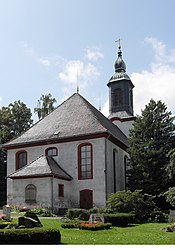
Each of the four districts has its own individual landmark. In Leubsdorf, the school built in 1911 is a landmark; it is now used as a primary school. In Marbach it is the culture and sports hall built in 1921, in Schellenberg the church built in 1777 and in Hohenfichte the wooden bridge over the Flöha, first built in 1602 .
- Evangelical Church Leubsdorf

Southeast side
Northeast side


Natural monuments
Parallel to the Flöha there is a 3.5 kilometer long bike and hiking trail from Hohenfichte via Schellenberg, Marbach, Leubsdorf and on to Grünhainichen .
Economy and Infrastructure
The economy in Leubsdorf is structured as small and medium-sized. The economic life is determined by craft and agricultural enterprises ( LPG ). Leubsdorf developed into a commercial location at the end of the 19th century. The emerging woodworking and processing industry displaced the artisanal manufacture of wooden goods, small furniture, household and kitchen appliances. From 1945 the manufacture of washbasins and cabinets began. Later complete kitchens were produced, today by the Ratiomat company. The cotton mill built by Max Hauschild has existed since 1833 and at times employed up to a thousand residents in the area. To this day, the manufacture of handicrafts made of wood is part of the community and has recently been supplemented by companies and trades in plastic and metal processing. On the southern edge of the village, in the direction of Borstendorf , there is an industrial park Borstendorfer Straße with an area of 11 hectares .
traffic
Leubsdorf is on the S236 between Augustusburg and Eppendorf . It runs as a main road in an east-west direction through the community and branches off as K7702 (Hammerleubsdorfer Straße) towards Gahlenz to the north. The next motorway entrances are in the north-west Frankenberg ( A 4 ) and Chemnitz-Süd ( A 72 ) in the west. In the lower part of Leubsdorf there is a station on the Chemnitz – Olbernhau line , on which the Erzgebirgsbahn runs.

Leubsdorf station, reception building (2016)

Leubsdorf station with the Erzgebirgsbahn (2016)
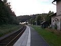
Leubsdorf station (2016)
.jpg)
.jpg)
.jpg)
Personalities
Sons and daughters of the church
- Adam Rechenberg (1642–1721), Lutheran theologian
- Ferdinand von Zschinsky (1797–1858), Minister of the Interior , Minister of Justice and Chairman of the entire Ministry in the Kingdom of Saxony
- Carl August Nendel (1798-1848), Bergmann and creator of Bergmännels between Hammerleubsdorf and Eppendorf
- Fips Fleischer (1923–2002), jazz musician and composer, born in Hohenfichte
- Karl-Hermann Hübler (* 1933), spatial planner and professor at the Technical University of Berlin
Personalities associated with the community
- Paul Bang (1879–1945), member of the Reichstag for the DNVP and for the NSDAP , State Secretary in the Reich Ministry of Economics, died in Hohenfichte
- Richard Meier (1878–1933), member of the Reichstag and member of the Weimar National Assembly, learned the trade of brewer here from 1893 to 1896
- The journalist Walter Barthel (1931–2003) lived in retirement, after the fall of the Wall until 2000, in Leubsdorf; his move from Bonn took place on horseback (accompanied by WDR ).
- The Berlin cabaret artist Martin Buchholz has a residence here.
literature
- Leubsdorf. In: The middle Zschopau area (= values of our homeland . Volume 28). 1st edition. Akademie Verlag, Berlin 1977, pp. 120-122.
- Richard Steche : Leubsdorf. In: Descriptive representation of the older architectural and art monuments of the Kingdom of Saxony. 6th booklet: Amtshauptmannschaft Flöha . CC Meinhold, Dresden 1886, p. 70.
- Leubsdorf . In: August Schumann : Complete State, Post and Newspaper Lexicon of Saxony. 5th volume. Schumann, Zwickau 1818, p. 639.
Web links
- Atlas Central Saxony
- official website of the municipality of Leubsdorf
- Leubsdorf in the Digital Historical Directory of Saxony
Individual evidence
- ↑ Population of the Free State of Saxony by municipalities on December 31, 2019 ( help on this ).
- ^ Historical book of place names of Saxony, Volume I, ed. by Ernst Eichler and Hans Walther , arr. by Ernst Eichler, Volkmar Hellfritzsch , Hans Walther and Erika Weber (sources and research on Saxon history 21), Berlin 2001, pp. 586–587.
- ↑ Results of the 2014 municipal council elections