
Leubsdorf (on the Rhine)
| coat of arms | Germany map | |
|---|---|---|

|
Coordinates: 50 ° 33 ' N , 7 ° 17' E |
|
| Basic data | ||
| State : | Rhineland-Palatinate | |
| County : | Neuwied | |
| Association municipality : | Linz on the Rhine | |
| Height : | 75 m above sea level NHN | |
| Area : | 10.22 km 2 | |
| Residents: | 1606 (Dec. 31, 2019) | |
| Population density : | 157 inhabitants per km 2 | |
| Postcodes : | 53547
53562 (Hesseln, Rothe-Kreuz) |
|
| Area code : | 02644 | |
| License plate : | NO | |
| Community key : | 07 1 38 037 | |
| Community structure: | 4 districts | |
| Association administration address: | Am Schoppbüchel 5 53545 Linz am Rhein |
|
| Website : | ||
| Local Mayor : | Achim Pohlen ( CDU ) | |
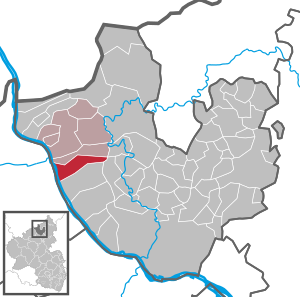
| Location of the local community Leubsdorf in the district of Neuwied | ||
  |
||

,_St._Walburgis_004.jpg)


Leubsdorf is a municipality in Rhineland-Palatinate on the Rhine in the Neuwied district . The community belongs to the Linz am Rhein association.
geography
Leubsdorf is located on the right bank of the Rhine south of Linz am Rhein and the local community Dattenberg . The municipality extends with the districts of Hesseln , Krumscheid and Rothe Kreuz up to the first heights of the Westerwald and reaches there with about 365 m above sea level. NHN its highest point. In the south the community borders on the city of Bad Hönningen . The entire municipality is located in the Rhine-Westerwald Nature Park .
_003.jpg)
,_Krumscheid_001.jpg)
history
The place was first mentioned in a document in 639 with the name "Lupstorf". With "Lupstorf" the "village of Lupo" or "des Luitprecht" is meant. This name indicates the rule of the Franks on the Middle Rhine around the year 500.
In this document from 639, Pippin the Elder († 640) gave his daughter Gertrud (626–659), the first abbess of Nivelles monastery , places with vineyards, forests and fisheries. "Lupstorf" is also listed here. With this donation, Leubsdorf comes under the influence of this monastery.
A donation from Countess Mechthild von Sayn shows that in 1250 she assigned her possessions, including Leubsdorf, to the Archbishop of Cologne, Konrad von Hochstaden , an uncle of Mechthild. Wonderfully country belonged Leubsdorf since then as part of the parish Linz to the Electorate of Cologne and shelter since the 15th century the administration of the Office Linz . The bishop of Trier remained the spiritual superior. After the Rhineland was ceded to the Kingdom of Prussia in 1815, the municipality was assigned to the newly formed Linz District (incorporated into the Neuwied District in 1822 ) and administered by the Linz Mayor's Office.
In a register of the church property of the diocese of Trier, a chapel in "Lupzstorf" is mentioned around 1250, which is considered the predecessor of today's parish church of St. Walburgis , built in 1906 .
In the Thirty Years' War Leubsdorf was completely destroyed, but rebuilt at the same place.
- Statistics on population development
The development of the population of Leubsdorf, the values from 1871 to 1987 are based on censuses:
|
|
politics
Municipal council
The municipal council in Leubsdorf consists of 16 council members, who were elected in the local elections on May 26, 2019 , and the honorary local mayor as chairman.
Distribution of seats in the elected municipal council:
| choice | SPD | CDU | GREEN | FWG | FDP | total |
| 2019 | 3 | 9 | 2 | 1 | 1 | 16 seats |
| 2014 | 5 | 9 | 1 | 1 | - | 16 seats |
| 2009 | 5 | 9 | 1 | 1 | - | 16 seats |
| 2004 | 4th | 10 | 1 | 1 | - | 16 seats |
- FWG = Free Voter Group Leubsdorf eV
mayor
Achim Pohlen is the local mayor of Leubsdorf. In the direct election on May 26, 2019, he was confirmed in his office for another five years with a share of the vote of 75.34%.
coat of arms


|
|
Blazon : "In silver a continuous black bar cross, in the upper corners the letters G and L."
The coat of arms has been legally valid since August 24, 1935, designed by Wilhelm Zender. |
| Justification of the coat of arms: The Kurkölsche cross refers to the former territorial affiliation of the municipality Leubsdorf. This itself is identified by its first letter. |
Culture and sights
Attractions
- The Gothic parish church of St. Walburgis towering on a rock , also known as the “White Church of the Rhine”, was built in 1905 in place of a previous church, of which the west tower and parts of the choir are still preserved. In the church there are statues and sculptures from the first half of the 14th century.
- The late medieval castle house in the middle of the old town center, a three-storey late-Gothic stone building crowned with half-timbered towers at the four corners. It originated in the middle of the 16th century and can be traced back to the 13th century.
- Numerous, lovingly cared for half-timbered buildings from the 18th century have been preserved in the town center.
- See also list of cultural monuments in Leubsdorf (am Rhein)
Regular events
- Traditional Walburgis fair : first weekend in May. A festival organized by the Catholic bachelor club in Leubsdorf. The fair in its present form was celebrated for the first time on May 1, 1733, the date the bachelor club was founded. Since then, little has changed at the events.
- Shooting festival : on the weekend after Corpus Christi
- Wine festival : last weekend in September (until 2007)
- Carnival parade : on Carnival Sunday
Economy and Infrastructure
traffic

In 1927 Leubsdorf was connected to the railway network on the right bank of the Rhine by building a train station here. Leubsdorf is a stop for regional train 27 ( Mönchengladbach - Cologne - Koblenz ).
The B 42 runs below Leubsdorf and connects with the cities in the direction of Bonn ( Linz am Rhein , Bad Honnef , Königswinter ) and in the direction of Koblenz ( Bad Hönningen , Neuwied ).
Hiking trails
The Rheinsteig , the long - distance hiking trail on the right bank of the Rhine from Bonn to Wiesbaden , leads through Leubsdorf. This is where the stage coming from Unkel ends (16.7 km, 500 meters in altitude) and the stage to Rheinbrohl (14.6 km, 463 meters in altitude) begins .
education
The first school in Leubsdorf is mentioned in 1729. Today Leubsdorf offers a kindergarten and a public library in addition to the primary school. Secondary schools are easy to reach in the nearby middle-class centers.
Others
Similar to many villages and towns in the area, the inhabitants of Leubsdorf were given a nickname that was often used for defamation. So they still carry the name "Knuddele" (nicknames in the neighboring towns: "Strünzer" Linz am Rhein , "Rööpe" Dattenberg , "Bunne" Bad Hönningen )
In the immediate vicinity of Leubsdorf, the so-called Vinxtbach Line , also known as the Leubsdorfer Line or Bad Hönninger Line , runs in an east-west direction, which marks both the former political border between Upper Germany and Lower Germany in Roman times, and subsequently the border between the areas of influence of the Archbishoprics of Trier and Cologne , as well as representing the language border between the two large Middle Franconian dialect groups for centuries , namely the Moselle Franconian group to the south and the Ripuarian group to the north .
Personalities
Sons and daughters of the church
- Heinz Schwarz (* 1928), former Minister of the Interior of Rhineland-Palatinate
- Ferdinand Pertzborn (1864 Leubsdorf – 1909 Bingen), music director in Bingen
literature
- Manfred Böckling: It is generally quiet. The beginning of the trench warfare on the Vosges front in 1914 as reflected in the war notebook of Joseph Klemen, secretary of the local court in Nastatter . In: Nassauische Annalen, yearbook of the association for Nassau antiquity and historical research . No. 121 , 2010, ISSN 0077-2887 , p. 277–313 (Klemen was born as the son of a winemaker in Leubsdorf / Rhein.).
Web links
Sources and individual references
- ↑ State Statistical Office of Rhineland-Palatinate - population status 2019, districts, communities, association communities ( help on this ).
- ↑ State Statistical Office Rhineland-Palatinate - regional data
- ↑ ELECTION RESULTS. Retrieved May 29, 2019 .
- ^ The Regional Returning Officer for Rhineland-Palatinate: direct elections 2019. see Linz am Rhein, Verbandsgemeinde, second line of results. Retrieved February 20, 2020 .

Cities: Bad Hönningen | Dierdorf | Linz on the Rhine | Neuwied | Uncle . Municipalities: Anhausen | Asbach | Bonefeld | Breitscheid (Westerwald) | Bruchhausen | Buchholz (Westerwald) | Dattenberg | Datzeroth | Dernbach | Döttesfeld | Dry wood | Ehlscheid | Drake | Oath of May | Hammerstein (on the Rhine) | Hanroth | Hardert | Harschbach | Hausen (Wied) | Hümmerich | Isenburg (Westerwald) | Kasbach-Ohlenberg | Kleinmaischeid | Kurtscheid | Leubsdorf (on the Rhine) | Leutesdorf | Linkenbach | Marienhausen | Meinborn | Melsbach | Neustadt (Wied) | Niederbreitbach | Niederhofen | Niederwambach | Oberdreis | Oberhonnefeld-Gierend | Upper wheels | Ockenfels | Puderbach | Ratzert | Raubach | Rengsdorf | Rheinbreitbach | Rheinbrohl | Rodenbach near Puderbach | Rossbach (Wied) | Rüscheid | Saint Catherine | Stebach | Steimel | Street house | Thalhausen | Urbach (Westerwald) | Vettelschoss | Waldbreitbach | Windhagen | Woldert .