Oberraden
| coat of arms | Germany map | |
|---|---|---|

|
Coordinates: 50 ° 33 ' N , 7 ° 32' E |
|
| Basic data | ||
| State : | Rhineland-Palatinate | |
| County : | Neuwied | |
| Association municipality : | Rengsdorf-Waldbreitbach | |
| Height : | 350 m above sea level NHN | |
| Area : | 4.33 km 2 | |
| Residents: | 640 (Dec. 31, 2019) | |
| Population density : | 148 inhabitants per km 2 | |
| Postal code : | 56587 | |
| Area code : | 02634 | |
| License plate : | NO | |
| Community key : | 07 1 38 054 | |
| Association administration address: | Westerwaldstrasse 32–34 56579 Rengsdorf |
|
| Website : | ||
| Local Mayor : | Achim Braasch | |
| Location of the local community of Oberraden in the Neuwied district | ||

Oberraden is a municipality in the Neuwied district in the north of Rhineland-Palatinate . It belongs to the community of Rengsdorf-Waldbreitbach .
geography
The place is located in the Rhine-Westerwald Nature Park north of Rengsdorf . The Niederraden district belongs to the municipality of Oberraden .
history
The place Oberraden was first mentioned in 1139 in a confirmation document from Pope Innocent II with the designation "Hadenhagen" as the property of the Laach Abbey. In 1147 the court at Niederraden was first opened by Pope Eugene III. mentioned as Laacher property. From then on, the place appears under different spellings: Adinhan, Adenhan, Adenhayn, Adenowe, Hadenhaga and Hadenhagen. The Lords of Aden also gave the place its name ( Ober-Aden ). The Laacher abbot Fulbert (1152–1177) handed over the place Folcholderoth (desert near Anhausen) to Ruthard von Adenhagen (Oberraden) in 1155 , with whom the local nobility (those of Aden) had already developed. The courtiers in Hadenhagen will be found more frequently in the future when the so-called Kindgedinge (division of children) is carried out by the rulership. Hen von Oberraden calls himself a Frei-Schultheiß in 1475. The wiedischen Count seized at the time of the Reformation of the possessions in and around Oberraden / Niederraden. The inhabitants freed themselves from serfdom in the middle of the 18th century , with reference to the castor courtship that had passed. From 1815 the lordship of Upper and Lower Raden is Prussian .
Cultural monuments
See the list of cultural monuments in Oberraden
Statistics on population development
The development of the population of Oberraden, the values from 1871 to 1987 are based on censuses:
|
|
politics
Municipal council
The municipal council in Oberraden consists of twelve council members, who were elected in a personalized proportional representation in the local elections on May 26, 2019 , and the honorary local mayor as chairman.
mayor
Achim Braasch became local mayor of Oberraden on July 3, 2014. In the direct election on May 26, 2019, he was confirmed in his office for another five years with a share of 87.67% of the votes. Achim Braasch's predecessor was Wilfried Rüdig.
coat of arms
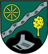
| Blazon : "In green a silver wavy strip to the left, below a black three-mountain, covered with a silver ploughshare and growing from it on the left a spherical tree, above a golden, eight-spoke wheel." | |
| Reasons for the coat of arms: The wheel in the coat of arms is not to be understood as a reference to agriculture, but is derived from the coat of arms of the Lords of ObeR-ADEN. The silver wavy strip symbolizes the Aubach, which flows east through Oberraden. The tree on the coat of arms is an approx. 160 year old spherical oak in the Aubach valley. It stands in the area of the former bone mill. |
Territorial reform 1974
As part of the territorial reform in Rhineland-Palatinate, which took effect on March 17, 1974, the previously independent municipalities of Niederraden and Oberraden were merged on this date.
traffic
The B 256 runs west of the community and leads from Neuwied to Altenkirchen . The next motorway junction is Neuwied on the A3 . The nearest ICE - Station is in Montabaur on the high-speed line Cologne-Rhine / Main .
literature
- Albert Hardt, Heinrich Beyer a. a .: Document book on the history of the Middle Rhine territories. 1860/2007, 5 volumes.
- Albert Hardt: In the Wiedisches Land. Rengsdorf 1989, pp. 436-456.
Web links
Individual evidence
- ↑ State Statistical Office of Rhineland-Palatinate - population status 2019, districts, communities, association communities ( help on this ).
- ↑ State Statistical Office Rhineland-Palatinate - regional data
- ^ The Regional Returning Officer Rhineland-Palatinate: Local elections 2019, city and municipal council elections
- ↑ Local community Oberraden: 1st meeting of the local council of the local community Oberraden (public). July 3, 2014, accessed March 14, 2020 .
- ^ The Regional Returning Officer Rhineland-Palatinate: direct elections 2019. see Rengsdorf-Waldbreitbach, Verbandsgemeinde, 14th line of results. Retrieved March 14, 2020 .
- ↑ Official municipality directory 2006 ( Memento from December 22, 2017 in the Internet Archive ) (= State Statistical Office Rhineland-Palatinate [Hrsg.]: Statistical volumes . Volume 393 ). Bad Ems March 2006, p. 191 (PDF; 2.6 MB). Info: An up-to-date directory ( 2016 ) is available, but in the section "Territorial changes - Territorial administrative reform" it does not give any population figures.


