Oberhonnefeld-Gierend
| coat of arms | Germany map | |
|---|---|---|

|
Coordinates: 50 ° 33 ' N , 7 ° 31' E |
|
| Basic data | ||
| State : | Rhineland-Palatinate | |
| County : | Neuwied | |
| Association municipality : | Rengsdorf-Waldbreitbach | |
| Height : | 391 m above sea level NHN | |
| Area : | 3.97 km 2 | |
| Residents: | 1029 (Dec. 31, 2019) | |
| Population density : | 259 inhabitants per km 2 | |
| Postal code : | 56587 | |
| Area code : | 02634 | |
| License plate : | NO | |
| Community key : | 07 1 38 053 | |
| LOCODE : | DE ONH | |
| Association administration address: |
Westerwaldstrasse 32–34 56579 Rengsdorf |
|
| Website : | ||
| Local Mayor : | Oliver frankincense | |
| Location of the local community Oberhonnefeld-Gierend in the district of Neuwied | ||
Oberhonnefeld-Gierend is a municipality in the Neuwied district in the north of Rhineland-Palatinate . The community belongs to the community of Rengsdorf-Waldbreitbach .
geography
The community is located in the Rhine-Westerwald Nature Park north of Rengsdorf .
Community structure
- Oberhonnefeld
- Yawing
- Yaw height
history
A church in Oberhonnefeld is first mentioned around 1000.
See also the list of cultural monuments in Oberhonnefeld-Gierend
- Population development
The development of the population of Oberhonnefeld-Gierend in relation to today's municipality; the values from 1871 to 1987 are based on censuses:
|
|
politics
Municipal council
The council in Oberhonnefeld-Gierend consists of 16 council members, who in the local elections on May 26, 2019 in a majority vote were elected, and the volunteer local mayor as chairman. Until 2014, the municipality council had twelve council members.
mayor
Oliver Weihrauch became the local mayor of Oberhonnefeld-Gierend on July 9, 2019. In the direct election on May 26, 2019, he was elected for five years with 87.96% of the vote. Oliver Weihrauch's predecessor was Rita Lehnert, who held the office for ten years.
coat of arms
|
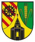
Blazon : “Split by a curved tip, inside a black church in front view, the tower with an open arched gate, split and open window in the bell storey and a pointed tent roof with a weathercock; front eight times diagonally divided by gold and red, occupied by an eight-spoke black gear wheel; behind in green a three-line golden ear, the stalk with two bent leaves. "
The coat of arms has been legally valid since June 3, 1981 based on a design by Albert Meinhard, Neuwied. |
|
| Foundation of the coat of arms: The golden-red diagonal division is the herald image of the oldest coat of arms of the Counts of Wied from 1218 and indicates that the municipality belonged to the allodial possession of the Counts of Wied. The gear symbolizes the former iron and copper mines and smelters in the parish of Honnefeld , which were in operation until the end of the 18th century . The ear of wheat symbolizes the cultivation of grain, the green the wooded surroundings of the community. The church shown is supposed to represent the Protestant parish church in Oberhonnefeld, a classicist hall church . |
traffic
The federal highway 256 runs east of the community and leads from Neuwied to Altenkirchen . The next motorway junction is Neuwied on federal motorway 3 . The nearest ICE - Station is in Montabaur on the high-speed line Cologne-Rhine / Main .
Personalities
- Martin Cremer (* 1913 in Oberhonnefeld; † 1988), librarian, head of the West German Library and the German Schiller Society
Web links
- Website of the local community Oberhonnefeld-Gierend
- Brief portrait of Oberhonnefeld-Gierend on Südwestrundfunk
Individual evidence
- ↑ a b State Statistical Office of Rhineland-Palatinate - population status 2019, districts, municipalities, association communities ( help on this ).
- ↑ State Statistical Office Rhineland-Palatinate - regional data
- ^ The Regional Returning Officer Rhineland-Palatinate: Local elections 2019, city and municipal council elections
- ↑ RW-Direkt: Minutes of the constituent meeting of the local community council of the local community Oberhonnefeld-Gierend on July 9th, 2019. Linus Wittich Medien GmbH, official gazette of the Verbandsgemeinde Rengsdorf-Waldbreitbach, edition 31/2019, accessed on March 13, 2020 .
- ^ The Regional Returning Officer Rhineland-Palatinate: direct elections 2019. see Rengsdorf-Waldbreitbach, Verbandsgemeinde, 13th line of results. Retrieved March 13, 2020 .
- ↑ Oberhonnefeld-Gierend is about to start over. NR-Kurier, May 9, 2019, accessed on March 13, 2020 .


