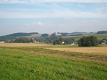
Müdisdorf
|
Müdisdorf
Municipality of Lichtenberg / Erzgeb.
Coordinates: 50 ° 49 ′ 43 ″ N , 13 ° 21 ′ 41 ″ E
|
||
|---|---|---|
| Height : | 440-510 m | |
| Incorporation : | January 1, 1963 | |
| Incorporated into: | Weigmannsdorf-Müdisdorf | |
| Postal code : | 09638 | |
| Area code : | 037323 | |
|
Location of Müdisdorf in Saxony |
||
Müdisdorf is a part of the municipality of Lichtenberg / Erzgeb. in the district of central Saxony (Free State of Saxony ). It was merged with Weigmannsdorf on January 1, 1963 to form the community Weigmannsdorf-Müdisdorf , which on October 1, 1993 to Lichtenberg / Erzgeb. was incorporated.
geography
location
Müdisdorf is about twelve kilometers south of Freiberg in the Eastern Ore Mountains . The location extends for several kilometers along a stream flowing east of the Freiberg Mulde . This has a connection in the west to the lower Großhartmannsdorfer pond , which is part of the nature reserve "Großhartmannsdorfer Großteich". The Müdisdorfer Kunstgraben and the Kohlbach-Kunstgraben , which are part of the Freiberg Revierwasserlaufanstalt , run northwest of the village .
Neighboring places
| Brand-Erbisdorf | Berthelsdorf | Weigmannsdorf |

|
||
| Großhartmannsdorf | Helbigsdorf |
history
Müdisdorf was mentioned in 1350 as "Mudingesdorf". In contrast to the neighboring village of Weigmannsdorf, which belonged to the Frauenstein office , was Müdisdorf and Lichtenberg / Erzgeb. until 1856 in the electoral or royal Saxon district office Freiberg . After 1696 the place was under the rule of the council to Freiberg. Ecclesiastically, the place was divided at that time. The upper part of the village was parish to Helbigsdorf, the lower part to Weigmannsdorf.
By order of the elector of January 23, 1558, the planned expansion of a water storage and supply system for Freiberg mining and metallurgy took place . At the same time, artificial trenches and florets were built based on suggestions from the chief miner Martin Planer . In the course of this, the lower Großhartmannsdorfer pond was also strengthened. The Müdisdorfer Kunstgraben and the Müdisdorfer Rösche were laid out from 1558, with the latter being built over a ten-year period. The Müdisdorfer Kunstgraben runs on the western slope of Müdisdorf. Above the Müdisdorf artificial ditch, the Kohlbach artificial ditch was probably built after 1562 as a drain from the Upper Großhartmannsdorfer pond . With the so-called Butzschutz or Bahnschütz there is the possibility of knocking off water in the Müdisdorf artificial ditch, which leads not far below. Both trenches are covered with wooden slabs or with concrete parts. In the past they were used indirectly for the additional supply of impact water for Freiberg mining, today they are part of the Freiberg Revierwasserlaufanstalt , which is of supraregional importance for the service and drinking water supply of the Chemnitz , Dresden and Freiberg regions .
From 1856 Müdisdorf belonged to the fire court office and from 1875 to the Freiberg district administration . With the second district reform in the GDR, Müdisdorf came to the Brand-Erbisdorf district in the Chemnitz district in 1952 (renamed the Karl-Marx-Stadt district in 1953 ). On January 1, 1963, Müdisdorf was merged with Weigmannsdorf to form the community Weigmannsdorf-Müdisdorf , which on October 1, 1993 to Lichtenberg / Erzgeb. was incorporated. With this Müdisdorf came from the Saxon district of Brand-Erbisdorf in 1994 to the district of Freiberg and in 2008 to the district of central Saxony.
traffic
The district road 7730 runs through the village, and Berthelsdorf / Erzgeb can be reached via the K 7731. To the west of the locality of Müdisdorf and in the Niederfrei forest, the Berthelsdorf – Großhartmannsdorf railway ran from 1890 to 1973 in the immediate vicinity of the Kohlbach artificial ditch, which it crossed four times. The "Haltpunkt Müdisdorf" went into operation when the railway line opened on July 15, 1890. With the cessation of travel on the Brand-Erbisdorf-Großhartmannsdorf section on December 2, 1973, the Müdisdorf stop was also taken out of service. Today only the “Bahnweg” in town reminds of him.
Web links
- Müdisdorf in the Digital Historical Directory of Saxony
- Website of Müdisdorf
- Müdisdorf at www.erzgebirge-explorer.de
Individual evidence
- ^ Karlheinz Blaschke , Uwe Ulrich Jäschke : Kursächsischer Ämteratlas. Leipzig 2009, ISBN 978-3-937386-14-0 ; P. 72 f.
- ↑ Flyer: Revierwasserlaufanstalt Freiberg, published by the state dam administration of the Free State of Saxony, November 2012, p. 2 (PDF; 290 kB), accessed on January 21, 2016
- ↑ Flyer: Revierwasserlaufanstalt Freiberg, published by the state dam administration of the Free State of Saxony, November 2012, p. 2 (PDF; 290 kB), accessed on January 21, 2016
- ^ The Amtshauptmannschaft Freiberg in the municipality register 1900
- ^ Müdisdorf on gov.genealogy.net


