Kohlbach-Kunstgraben
| Kohlbach-Kunstgraben | ||
| Data | ||
| location | Germany | |
| source | as an outflow from the Upper Großhartmannsdorfer pond 50 ° 47 ′ 6 ″ N , 13 ° 19 ′ 21 ″ E |
|
| muzzle | Reicher Bergsegen mine south of Brand-Erbisdorf Coordinates: 50 ° 50 ′ 56 " N , 13 ° 19 ′ 37" E 50 ° 50 ′ 56 " N , 13 ° 19 ′ 37" E
|
|
| length | 12.2 km | |
The Kohlbach-Kunstgraben is an artificial ditch between Großhartmannsdorf and Brand-Erbisdorf in the Ore Mountains from the 16th century. It served the additional supply of impact water for the Freiberg mining and is part of the Freiberg Revierwasserlaufanstalt .
course

The approximately 12.2 km long Kohlbach artificial ditch begins as an outflow from the Upper Großhartmannsdorfer Pond at the southern end of Großhartmannsdorf. It then crosses under the B 101 and from then on leads west of the village to the north, where it has disappeared in the area of the church . To the west of the middle Großhartmannsdorfer pond it crosses its tributary, the Landhainbach. The ditch can also take in water from the stream or feed it through the Landhainschütz . From this point the ditch leads in a north-easterly direction, passing under the B 101 a second time at the northern exit of Großhartmannsdorf and continuing along the western slopes of Müdisdorf. With the so-called Butzschutz or Bahnschütz there is the possibility of knocking off water in the Müdisdorf artificial ditch , which leads not far below . Before reaching the district road from Müdisdorf to Berthelsdorf, the ditch swings in a north-westerly direction and leads through the Niederfrei forest in which the Münzbach is crossed. North of the Reicher Bergsegen mine , in the area of the former waterworks, the ditch divides. One arm leads further west to the Gelobt Land pond south of Brand-Erbisdorf, the other to the Neuglück and Drei Eichen pits to the north . The Reicher Bergsegen mine itself also used the impact water that was brought in.
history
The planned expansion of a water storage and supply system for Freiberg mining and metallurgy began on January 23, 1558 by the electoral order. From 1562, the construction of artificial trenches and florets took place in parallel according to the suggestions of the chief miner Martin Planer . It can be assumed that in the course of this the moat was created as part of this system after 1562.
Elsewhere, the year 1550 is mentioned, according to which the ditch originally only served to feed the pits south of Brand-Erbisdorf and was only later integrated into the system of the Revierwasserlaufanstalt.
At the beginning of the 19th century the moat was widened and lined. The section leading through the lower free forest was shortened and led differently. The city of Freiberg sold the Stolln and Röschen administration the then still-preserved foundation walls of the old court as building material. In the 1840s, the forest rifle, through which water was drained into the forest ponds during floods, was bricked up by the city of Freiberg.
Today the Revierwasserlaufanstalt is of supraregional importance for the service and drinking water supply of the Chemnitz , Dresden and Freiberg regions .
additional
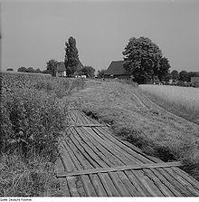
The ditch got its name after the Kohlbach, which it crosses and which is partly integrated into the ditch. The trench walls consist of dry masonry and at the time it was common to cover large parts with wooden slabs . As a result, leaves and grass could not obstruct the flow of water, evaporation losses kept low and accidents avoided as far as possible. Since the ditch, as part of the upper RWA, still serves to provide drinking water today, the rind cover can only be seen at a few touristically significant places, but otherwise replaced by concrete slabs.
To the west of the locality of Müdisdorf and in the Niederfrei forest, the Berthelsdorf – Großhartmannsdorf railway ran from 1890 to 1973 in the immediate vicinity of the ditch and crossed it four times.
photos
Web links
Individual evidence
- ↑ Saxony Atlas. Retrieved March 12, 2014 .
- ↑ a b c Description in the "MontE" database of the Institute for Science and Technology History (IWTG) at the Technical University of Freiberg ( Memento of the original from January 21, 2016 in the Internet Archive ) Info: The archive link was inserted automatically and has not yet been checked. Please check the original and archive link according to the instructions and then remove this notice. , accessed August 6, 2010
- ↑ Flyer: Revierwasserlaufanstalt Freiberg, published by the state dam administration of the Free State of Saxony, November 2012, p. 2 (PDF; 290 kB), accessed on January 21, 2016
- ^ Revierwasserlaufanstalt des Freiberg Bergreviers ( Memento from May 14, 2007 in the Internet Archive ), accessed on August 9, 2010


