
Müdisdorfer Kunstgraben and Rösche
| Müdisdorfer Kunstgraben and Rösche | ||
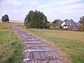
 Müdisdorfer Kunstgraben north of Müdisdorf |
||
| Data | ||
| location | Saxony , Germany | |
| River system | Elbe | |
| Drain over | … → Münzbach → Freiberger Mulde → Mulde → Elbe → North Sea | |
| source | as an outflow of the lower Großhartmannsdorfer pond 50 ° 48 '46 " N , 13 ° 20' 26" E |
|
| muzzle | in the Rothbächer pond or the Hohbirker Kunstgraben
|
|
| length | 6.2 km (of which approx. 2.1 km have disappeared) |
|
The Müdisdorfer Kunstgraben with the section of the Müdisdorfer Rösche is an artificial ditch between Großhartmannsdorf and Brand-Erbisdorf in the Ore Mountains from the 16th century.
It indirectly served the additional supply of impact water for the Freiberg mining and is part of the Freiberg Revierwasserlaufanstalt .
course
.jpg)
The Müdisdorfer Kunstgraben begins as an outflow from the Lower Großhartmannsdorfer Pond at the southern end of Müdisdorf . It then follows the location in a northeasterly direction and runs along the western slope of the village located in a valley. On the same slope runs further above the Kohlbach-Kunstgraben , over which the so-called Butzschutz or Bahnschütz gives the opportunity to knock off water into the Müdisdorf Kunstgraben. After about 3.6 kilometers, the ditch turns to the northwest into a small side valley and runs through a 300 meter long rose. Before entering the approximately 1.8 km long Müdisdorfer Rösche after about 4.4 kilometers . The rose has a largely straight course, but has been slightly changed several times in its course since it was built. There is a division within the rose, which means that there are two drainage paths. Via the two mouth holes , the water can be fed into the Rothbach pond or the Hohbirker Kunstgraben immediately after it emerges again.
history
The planned expansion of a water storage and supply system for the Freiberg mining and metallurgy industry began on January 23, 1558 by order of the elector. At the same time, the construction of artificial trenches and florets took place according to the suggestions of the chief miner Martin Planer . In the course of this, the lower Großhartmannsdorfer pond was also strengthened.
The Müdisdorfer Kunstgraben and the Müdisdorfer Rösche were laid out from 1558, with the latter being built over a ten-year period. The Rösche was excavated with a large number of light holes in the opposite direction, later the course was corrected and wrapped several times. It also includes the Röschenhaus and several daytime mining buildings. The construction management was incumbent on Martin Planer, who used this rose to create an underground waterway from the lower Großhartmannsdorfer pond, with which fire pits could also be supplied with impact water.
The Röschenhaus was looted and burned down during the Napoleonic Wars in 1813.
Today, the watercourse is of supraregional importance for the service and drinking water supply of the Dresden and Freiberg regions .
additional
At the time, it was common to cover large parts of the ditch with wooden slabs so that leaves and grass did not obstruct the flow of water. Since the ditch is still used today for the service water supply, this was partially replaced by a concrete cover in the 20th century.
In order to increase the amount of water available in the lower Großhartmannsdorfer pond - and thus that for the Müdisdorfer Kunstgraben - this was supplemented in 1564 by the artificial inflow of the Zethauer Kunstgraben , which brings part of the water from the Zethaubach and smaller streams from the valleys southwest of Helbigsdorf in passed over the pond.
photos
Müdisdorfer Kunstgraben in Müdisdorf (2016)

Müdisdorfer Kunstgraben in Müdisdorf (2016)
.jpg)
.jpg)
Web links
Individual evidence
- ↑ Saxony Atlas. Retrieved March 12, 2014 .
- ↑ a b Description in the "MontE" database of the Institute for Science and Technology History (IWTG) of the Technical University of Freiberg ( Memento of the original from January 21, 2016 in the Internet Archive ) Info: The archive link was inserted automatically and has not yet been checked. Please check the original and archive link according to the instructions and then remove this notice. , accessed August 16, 2010
- ↑ a b Flyer: Revierwasserlaufanstalt Freiberg, published by the state dam administration of the Free State of Saxony, November 2012, p. 2 (PDF; 290 kB), accessed on January 21, 2016
- ↑ Mine ponds south of Brand-Erbisdorf in the Ost-Erzgebirge nature guide , accessed on August 17, 2010