
Cammerswalde
|
Cammerswalde
Municipality Neuhausen / Erzgeb.
Coordinates: 50 ° 42 ′ 35 ″ N , 13 ° 30 ′ 5 ″ E
|
|
|---|---|
| Height : | 617 (545-716) m |
| Residents : | 589 (December 31, 2012) |
| Incorporation : | January 1, 1994 |
| Postal code : | 09544 |
| Area code : | 037327 |
 Location of Cämmerswalde in the district of central Saxony and in the municipality of Neuhausen / Erzgeb.
|
|

The district of Cämmerswalde in the community of Neuhausen / Erzgeb. is located in the south of the Saxon district of Central Saxony .
The over 800 year old town is located near Seiffen in the westernmost Eastern Ore Mountains on the Czech border. It was laid out as a classic forest hoof village and extends over more than five kilometers. Cämmerswalde is subdivided into Oberdorf, Mitteldorf and Niederdorf. Since 1994 Cämmerswalde has belonged to the municipality of Neuhausen / Erzgeb., Was previously an independent municipality with the districts Deutschgeorgenthal , Haindorf and from 1924 also Neuwernsdorf and Rauschenbach .
geography
location
Cämmerswalde is located north of the Ore Mountains ridge in the direct transition area from the Eastern Ore Mountains to the Middle Ore Mountains , embedded in the upper Flöhatal , between Neuhausen, the communities of Rechenberg-Bienenmühle and Sayda in the Ore Mountains / Vogtland Nature Park . Direct neighboring markings are Holzhau , Neuwernsdorf, Neuhausen, Rauschenbach, Friedebach and Clausnitz as well as the neighboring Czech municipality Český Jiřetín (Georgendorf).
From the southernmost district boundary 545 m above sea level. NHN extends Cämmerswalde over the former Lösermühle at 558 m above sea level. NHN through the center (church) at 640 m above sea level. NHN up to 716.8 m above sea level NHN highest point of the Klötzerweg / White River Trail (Ringel). The district of Cämmerswalde is 13.05 km².
The village is traversed by the Cämmerswalder Dorfbach . To the south of the village, the Flöha is dammed in the Rauschenbach dam.
geology
The place is located on crystalline schist and gneiss . While gray gneisses predominate in the Eastern Ore Mountains, more coarse-grained red gneisses are also found here. In the area of the Flöhatals lies a very old, tectonically mobile zone that separates the Eastern and Central Ore Mountains. In geological terms, the Flöha zone probably played a role in the Erzgebirge uplift.
climate
Average temperature and precipitation values
Source: Measured values 1973–2000 (temperature), 1991–2000 (precipitation), measuring station Rauschenbach at 615 meters above sea level. NN at the dam wall
| Jan. | Feb | March | Apr | May | Jun. | Jul. | Aug | Sep | Oct | Nov | Dec | Annual average | |
|---|---|---|---|---|---|---|---|---|---|---|---|---|---|
| Temp. ( ° C ) | −1.5 | −1.1 | 1.7 | 5.9 | 10.8 | 13.5 | 15.6 | 15.3 | 11.3 | 6.8 | 1.5 | −1.4 | 6.5 |
| Precipitation ( mm ) | 82 | 61 | 76 | 68 | 76 | 93 | 112 | 98 | 74 | 65 | 79 | 91 | 957 |
history
The settlement of Cämmerswaldes took place in the course of the colonization of the Upper Saxon area around the year 1000. At that time, a huge primeval forest stretched over the mountains. The mountains were only given the name Erzgebirge after their ore wealth became known.
Place name
The place name Cämmerswalde goes back to the name " Chamberlain of the Kingdom of Bohemia". The place was evidently first mentioned in 1213 as Kämmerswalde. Whether as the namesake of the noble family of the Hrabischitz , as Župan of Belina and chamberlain of the Kingdom of Bohemia, testified Grabissa III. served, or his brother Slauko I. von Hrabischitz , also Slawek I. , is not documented. Slauko the Great , also Slavek Magnus , Slackko von Riesenburg († 1226 in Ossegg ) was a Bohemian prince, around 1207 burgrave in Bilin and highest chamberlain 1198–1202 1212–1226. Slauko founded the Ossegg monastery and brought the Cistercian monks from Maschau to Ossegg from the Bavarian Waldsassen monastery in 1199 . Well-known traditional versions of names or spellings of the place name are Kemerswalde , Komerßwalde , Kemmerßwalde , Kamerßwalde , Kemmerschwalde , Kemmerswalde and (until 1945) both Kämmerswalde and Cammerswalde .
Foundation of the village and the Middle Ages
It is very likely that it was the monks of the Hrabischitz from the Ossegg monastery who, on behalf of the Bohemian King Ottokar I. Přemysl (1155-1230) and farmers from the Franconian Forest, took over the area on the upper reaches of the Flöha and thus also Cämmerswalde, Sayda (first mentioned in 1192 as Zawidowe) and Friedebach around 1200. The monks had previously been summoned from the Bavarian Waldsassen Monastery to found the Ossegg Monastery in Northern Bohemia in 1192, from where the Bohemian colonization was to start. According to records of the local researcher of the Saydaer Bergland, Cantor Max Rennau, the "first mention of 1207 and a documented interest obligation, Akta Spuria / 385 S '- Regina Bohemiae" of the Bohemian king, in which all subjects of the Ossegg monastery receive a certain interest had numbers and thus mentioned the existence of the places around Sayda. In the meantime, however, an earlier settlement is assumed, because Grabissa III. , also Hrabiš III. the colonization of Bohemia across the ridge of the Ore Mountains to the north began during his activity as the highest treasurer (until his death in 1197).

20th century
- 1902: The gymnastics club Cämmerswalde was first mentioned.
- 1911: Cämmerswalde received an electrical network.
- 1920: A shooting range for the small bore and rifle club was inaugurated.
- 1921: Two new church bells were purchased and consecrated for the two church bells that were confiscated and melted down during the First World War . These had to be returned to the arms industry in World War II. What was left was the smallest bell.
- 1924: Neuwernsdorf was incorporated into Cämmerswalde.
Cämmerswalde in the two world wars
The two world wars also claimed victims here. During the First World War , Cämmerswalde and its districts suffered 38 victims; a census in 1939 showed 1,683 inhabitants.
In the same year a barracks camp of the Reich Labor Service (RAD) was opened in the village .
Towards the end of the Second World War, in April 1945, retreating Wehrmacht troops marched through Cämmerswalde for several days. In the aerial warfare over the Ore Mountains, farmers were also shot at by English low-flying aircraft while they were working in the fields in Cämmerswalde. Several duds from the bombing raids etc. a. on Dresden and Brüx struck between 1943 and 1945 in Cämmerswalde.
On the evening of May 7, 1945, the Red Army entered Cämmerswalde despite the tank barriers . The bridge at the Lösermühle and the hay bridge to Neuwernsdorf had previously been blown up by the Wehrmacht when they withdrew and the road between Neuwernsdorf and Rauschenbach was mined.
Post-war period and GDR
The place, especially the school, inns and the barracks of the former Reich Labor Camp as well as many private houses were completely overcrowded with refugees from the former German areas and bombed cities; well over 2,000 people were in Cämmerswalde in May 1945. The Soviet local command under Anatoli Kalinin was established on Herbert Mai's farm at Hauptstrasse 6 by autumn 1945. Karl Horn was selected as acting mayor. He had to organize the accommodation and care of the refugees and enforce tax obligations for the farmers. Despite food stamps , there was acute famine. A census on November 3, 1945 showed 1,868 inhabitants. The invasion was followed by looting and rape, a homestead was burned down, and the fire brigade was not allowed to move out. In the course of the liberation, Soviet soldiers shot seven citizens, two people killed themselves, one died while clearing mines. Three residents were sent to internment camps , one died there.
At the end of the Second World War , 120 residents were killed.
- 1945: On September 10th, the ordinance on land reform was enacted, which led to the expropriation of the large landowners, the von Schönberg and von Purschenstein families in Neuhausen / Erzgeb. led.
- 1949: Inauguration of the sports field on October 7th, the day the GDR was founded
- 1952: Cämmerswalde belonged to the newly created district of Chemnitz (as of 1953 Karl-Marx-Stadt) and was the Brand-Erbisdorf district assigned
- 1954: Consecration of the bells of the two new bells from Apolda for Cämmerswalder Church
- 1957: Over 20,000 visitors flocked to Cämmerswalde for the 750th anniversary celebration with a parade
- 1958: Cämmerswalde got new street lighting
- 1959: The German border police moved to a new barracks in Cämmerswalde for two years.
- 1963: The foundation stone for the construction of the Rauschenbach dam was laid on October 4th, and the inauguration took place on October 4th, 1967.
- 1968: The FDGB vacation home Paul Gruner received the first vacationers on July 1st.
In connection with the unrest of the Prague Spring , the SMAD dispatched Soviet troops to the Eastern Ore Mountains. They camped for weeks in the woods around Cämmerswalde and advanced towards Prague on August 21 . - 1970: Due to heavy snowdrifts, there was a disaster alarm at the beginning of March.
- 1972: Cämmerswalde received the title of state-approved resort on September 15th .
- 1973: An Il-14 was dismantled and brought from Barth to Cämmerswalde and rebuilt as a sight. The plane served as a restaurant for a while.
- 1975: The new kindergarten with crèche was completed. The children moved from the former RAD barracks to the new station wagon building.
- 1977: A kind of polyclinic was created by converting an existing building. For the 100th school anniversary, the school was renovated and an extension was opened.
After the turn
- 1990: The first free elections in the GDR took place on March 18. Wolfgang Wagner (CDU) replaced the mayor Werner Hegewald (SED), who had been in office since 1964, but had to take up his post in Cämmerswalde on the occasion of the community unification with Neuhausen / Erzgeb. Delivered at the end of 1993. Between 1994 and 2001, however, Wagner also chaired the unified congregation.
- 1991: The Federal Border Guard moved into the former barracks of the border troops / NVA.
- 1993/1996: The municipality of Cämmerswalde decided to build the guest house . The 9.2 million euro project was approved with 90 percent funding: on this occasion, an initially planned multi-purpose gym was transformed into a cultural center with a multi-purpose gym, restaurant, hall, sauna and bowling alley. The inauguration took place in 1996, after which it became known that the building was not fully eligible due to changes in the building plan. A complicity was given to the approving regional council Chemnitz, which examined the new building plan, but did not warn. The municipal council was not aware of the new funding guidelines of the Free State of Saxony. Part of the funding had to be repaid.
- 1994: The district reform of January 1st united Cämmerswalde and its districts with the community of Neuhausen / Erzgeb. On July 1, the Brand-Erbisdorf district was dissolved and the Freiberg district returned .
- 1995: On January 1st, after 50 years, the Deutschgeorgenthal / Český Jiřetín border crossing was reopened for pedestrians. In 2008 it was also released for road traffic .
- 2000: The construction of a long-distance water pipeline between the Rauschenbach and Lichtenberg / Erzgeb dams . was started.
- 2002: On March 14, specialists blew up the dilapidated dam bridge on the S 211 state road, which runs close to the border .

- 2004: The new dam bridge is opened to traffic on August 24th
- 2007: In July Cämmerswalde celebrated a week of celebrations for the 800th anniversary with a large parade, at the same time the 130th anniversary of the school was celebrated with a large exhibition in the school.
- 2009: In May the state government of Saxony rejected an application from the Neuhausen / Erzgeb community. to revitalize the region, the gentle tourist use of the drinking water dam Rauschenbach for motorless small boats.
Administrative history
In 1551, Cämmerswalde belonged to the Purschenstein manor . In the years after 1696 the manor Purschenstein also belonged to the Freiberg office . The Sayda court office took over the place in 1856 and handed it over to the Amtshauptmannschaft Freiberg in 1875 . In the GDR, Cämmerswalde belongs to the Brand-Erbisdorf district from 1952. 1994 to 2009 the place belongs to the district of Freiberg. The former district of Freiberg and the unified community of Neuhausen / Erzgeb have belonged to them since 2009. to the district of central Saxony.
politics
Community leader and mayor
see table on the right
| Community boards and mayors | |
|---|---|
| until 1838 | Friedrich B. Felber (last testator) |
| March 5, 1839-1850 | Johann G. Muller |
| 1850-1869 | August F. Hegewald |
| 1869-1886 | Wilhelm H. Fischer |
| 1886-1916 | Gustav A. Bilz |
| 1916-1937 | Robert Hegenbart |
| 1937-1944 | Willy Hegewald |
| 1944-1945 | Alfred Meyer |
| 1945-1947 | Karl Horn |
| 1947-1949 | Karl Hebert |
| 1949-1951 | Karl Wagner |
| 1951-1953 | Walter Martin |
| 1953-1954 | Herbert Braun |
| 1954-1956 | Rolf Barthmann |
| 1957-1963 | Heinz Sattler |
| 1963-1964 | Horst Meyer |
| 1964-1990 | Werner Hegewald |
| 1990-1993 | Wolfgang Wagner |
| 01/01/1994 | incorporated into Neuhausen |

Location logo
The design of the logo dates back to the time when the municipality was independent (until 1994). It was created around 1990 in monochrome as a kind of replacement for a missing historical coat of arms and is still used today by the municipality of Neuhausen / Erzgeb. used parallel to their local coat of arms. After the dam was built in Rauschenbach and when it was recognized as a state-approved resort in the GDR in 1973, there is said to have been a similar community logo with this drawing. The logo shows an old mill building or Erzgebirgshaus (possibly the "Lösermühle"), below it the bridge over the storage space and to the right of it the church in front of the panorama of the Schwartenberg. Below that, the dam of the Rauschenbach dam is depicted across its entire width. The logo is still available in a single color with the two-line text "Cämmerswalde / Erzgebirge" under the shortened dam.
Population development
- 1486: 34 possessed man
- 1501: 34 possessed man
- 1551: 34 possessed men, 87 inhabitants
- 1576: 12 Vollhüfner, 15 Halbhüfner, 6 Viertelhüfner, 17 cottagers - 10 to 12 housemates (no own fireplaces) accordingly: 33 farmers cultivate 21 Hufen (farms), probably 51 families are resident in the village around 1576
- 1764: 33 possessed men, 39 cottagers, 19 three-quarter hoppers
- 1834: 852 - of which Cath. 1
- 1868: 1,254
- 1871: 974
- 1890: 1,028
- 1910: 1.110
- 1925: 1,517 - including ev.-luth. 1,485; cath. 26; other 6
- 1939: 1,683 (September - census)
- 1945: 1,868 (November 3rd - census)
- 1946: 1,884
- 1950: 1,832
- 1964: 1,707
- 1970: 1,504
- 1981: 1,360 (census)
- 1990: 1,100
- 1994: 1,271 (census: territory before unification with Neuhausen)
- 2006: 679 (from here only the OT Cämmerswalde without Deutschgeorgenthal, Neuwernsdorf and Rauschenbach)
- 2007: 673


Wildlife in and around Cämmerswalde
Some rare animal species are native to the Rauschenbachtalsperre and the neighboring districts:
- Otter : The otter is back at home at the Rauschenbachtalsperre and its tributaries.
- Northern bat : Evidence comes from Oberlochmühle near Sayda on old chimneys and gables.
- Birds : Wood warbler , stock dove , black woodpecker , gray woodpecker and miniature flycatcher occur in the beech stocks of the surrounding forests. In spruce stands rare species such as the barn owl , pygmy owl , woodcock , at times also night swallow , treecreeper , willow tit and dwarf woodpecker , in open spaces also the owl and occasionally the black grouse can be found.
- The evidence of 108 breeding and migratory bird species in the forest area between Deutscheinsiedel and the upper Flöhatal was the reason to create a European bird sanctuary (1,337 ha), which is integrated into the Europe-wide Natura 2000 network of protected areas .
- In spring and autumn, many Nordic water birds rest at the Rauschenbach dam , including various types of ducks, saws, geese and divers. Ornithologists have also observed the dipper on the Flöha .
- Falter : Over 30 different butterflies as swallowtail butterfly , Bluebird or whiting are around Cämmerswalde at home. The Green League of East Thuringia has identified 679 species of butterflies in the Eastern Ore Mountains, 570 of which are moths and 96 day butterflies. Six of them are missing, about 60 percent were included in the Red Lists of Saxony and Germany. The causes of the threat are changes in the biotope due to a lack of meadow mowing and woody growth.
- Fish : In the Rauschenbach dam you can find a. Brown trout , lake trout , rainbow trout , carp , perch , tench , eel , pike , pikeperch , chub and roach .
Culture and buildings

church
The Romanesque baroque church that dominates the panorama of the central village was rebuilt in 1703. Above the entrance you can read: "In 1703, the 7th of May, this church building was started with God and was well completed on July 17th, 1708." The church building has an artistic coffered ceiling and an artistically valuable altarpiece and is one of the most magnificent baroque churches of the region from the 18th century in the "peasant baroque" style. How old the church really is remains unclear. The year 1499 is on the oldest of the three bells. There are several memorial stones in the cemetery.
Attractions
Inspection planes
There are two inspection planes and a helicopter in Cämmerswalde. An Il-14 of the GDR airline Interflug has been standing in Cämmerswalde since 1973 . A MiG-21PFM has also been installed since 2001 . In August 2006, a Mi-2 helicopter from the Soviet airline Aeroflot followed .
- The Ilyushin Il-14

Disused Interflug machine Il-14 in Cämmerswalde

Cockpit of the Il-14 in Cämmerswalde, April 2009
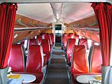
Passenger cabin of the Il-14 in Cämmerswalde, April 2009


Tourism / winter sports

- winter
There are numerous winter sports facilities around Cämmerswalde. In winter there are over 30 km of cross-country ski trails on the Ringelweg in the direction of Holzhau and Clausnitz , as well as on the Floßgrabenweg. Since 1923, the Schwartenberglauf has attracted great interest from cross-country skiers from all over Germany. In Holzhau, Neuhausen / Erzgeb. and Heidersdorf there are downhill slopes. There are opportunities for snowmobile rides and horse-drawn sleigh rides in the area. The cross-country skiing race Floßgrabenlauf , which celebrated its 30th edition on January 30, 2010 below the "Ringel" in Cämmerswalde, is attractive for popular athletes . The race traditionally offers distances between 500 meters and 15 kilometers.
- Spring / summer / autumn
Cämmerswalde is the starting point for a variety of hikes on signposted paths. Through dense beech and spruce forests in the Ore Mountains, Seiffen can be reached via the Schwartenberg (approx. 14 km), in other directions Rechenberg-Bienenmühle, Holzhau (approx. 7 km), Neuhermsdorf (18 km) and Altenberg (37 km) are to be found to reach. A starting point is the parking lot at the restaurant at the airplane, directly at a hiking trail cross. In the direction of Bohemia there are hiking routes via the Deutschgeorgenthal border crossing to Teplice (Teplitz), Ossegg (Osek) or Krupka (Graupen).
Sports
.jpg)
The sports community (SG) Einheit Cämmerswalde-Clausnitz was founded in the village in 1949 and existed until 1953. In 1958, the company sports community (BSG) Traktor Cämmerswalde was established , to which the winter sports section also belonged, whose participants had some successes in young sports . For a short time, Cämmerswalde was even a training base for the Karl-Marx-Stadt district in Nordic skiing.
The successor club is the sports club (SV) Eintracht Cämmerswalde, founded in 1990, with the departments volleyball and winter sports. The soccer department of SV Eintracht Cämmerswalde merged in 2007 with the soccer department of SSV Blau-Weiß Neuhausen to form FV Neuhausen-Cämmerswalde and has since played its games in the Neuhausen Schwartenberg Stadium and on the Cämmerswalder sports field next to the "Haus des Gastes".
Persons connected with Cämmerswalde
- Wilhelm Walther : (1826–1913), born in Kämmerswalde in the former Oehme-Gut (Hauptstrasse 171). Artist and creator of the Fürstenzug at Dresden Castle
- The Jehmlich brothers: Gotthelf Friedrich, Johann Gotthold, Carl Gottlieb and Gottlob Friedrich were born in the later Neuwernsdorf district of Cämmerswalde in house number 48 (formerly Helmut Hegewald). The four brothers learned the carpentry trade from their father, the youngest took over the business, the other three brothers trained as organ builders and founded the Jehmlich Orgelbau company in Neuwernsdorf in 1808 . In 1818 Gotthelf Friedrich created the first Jehmlich organ in Lauenstein . In 1826 Johann Gotthold moved to Dresden , where he built a workshop and in 1836 he became “Royal Saxon Court Organ Builder”. In 1839 Carl Gottlieb opened a workshop in Zwickau , which was continued until 1874. Since 2006, the Dresden company has been managed by Ralf Jehmlich in the sixth generation.
- Ernst Adolf Herrmann : Historian (born March 25, 1812 in Kämmerswalde, † September 23, 1884 in Marburg), continued the work of Dr. Philipp Strahl continued the history of the Russian state (1846–1866).
literature
- Festschrift 750 years of Cämmerswalde. Reinhard Rodefeld, 1957
- Commemorative publication 800 years of Cämmerswalde. Festival committee, Reinhold Hegewald, 2007
- About Olbernhau and Seiffen (= values of our homeland . Volume 43). 1st edition. Akademie Verlag, Berlin 1985.
- Max Rennau: On the oldest history of the church in Cämmerswalde. Erzgebirgischer Generalanzeiger, 1930
- Historical book of place names of Saxony. 3 volumes, ed. by Ernst Eichler and Hans Walther , arr. by Ernst Eichler, Volkmar Hellfritzsch , Hans Walther and Erika Weber (sources and research on Saxon history 21), Berlin 2001, Volume I, p. 135
- Richard Steche : Cämmerswalde. In: Descriptive representation of the older architectural and art monuments of the Kingdom of Saxony. 3. Issue: Amtshauptmannschaft Freiberg . CC Meinhold, Dresden 1884, p. 3.
- Cammerswalde . In: August Schumann : Complete State, Post and Newspaper Lexicon of Saxony. 4th volume. Schumann, Zwickau 1817, p. 410.
Web links
- Official homepage of the community of Neuhausen
- Organs in the Freiberg church district ( Memento from February 2, 2011 in the Internet Archive )
- Cämmerswalde in the Digital Historical Directory of Saxony
Individual evidence
- ↑ Population figures on neuhausen.de ( Memento from March 3, 2015 in the Internet Archive )
- ↑ Green League Eastern Ore Mountains Nature Guide - Volume 3 - Natural history hiking destinations in the Eastern Ore Mountains, pages 47 and 56.
- ↑ Saxon State Office for Environment and Geology
- ↑ a b c d e Reinhold Hegewald: Festschrift 800 years of Cämmerswalde. 2007.
- ^ Notes of the local researcher of the Saydaer Bergland, Cantor Max Rennau
- ↑ Cämmerswalde in the Digital Historical Directory of Saxony
- ↑ Record of the collection of the Turkish tax by the Cämmerswalder Ehrbarmschaft, 1486
- ↑ Turkish Tax Directory, 1501
- ^ Church and school news for 1868
- ↑ a b c d Cämmerswalde community archive
- ↑ Nature guide Green League Osterzgebirge - Volume 1 - Plants and animals
