Krupka
| Krupka | ||||
|---|---|---|---|---|
|
||||
| Basic data | ||||
| State : |
|
|||
| Region : | Ústecký kraj | |||
| District : | Teplice | |||
| Area : | 4660.5843 ha | |||
| Geographic location : | 50 ° 41 ' N , 13 ° 51' E | |||
| Height: | 300 m nm | |||
| Residents : | 12,624 (Jan 1, 2019) | |||
| Postal code : | 417 42 | |||
| License plate : | U | |||
| structure | ||||
| Status: | city | |||
| Districts: | 9 | |||
| administration | ||||
| Mayor : | PhDr. Ing.Zdeněk Matouš (status: 2018) | |||
| Address: | Mariánské nám. 22/13, Bohosudov 417 42 Krupka 1 |
|||
| Municipality number: | 567639 | |||
| Website : | www.krupka-mesto.cz | |||
| Location of Krupka in the Teplice district | ||||

|
||||
Krupka ( German Graupen ) is a town in Ústecký kraj in the Czech Republic . The well-preserved monument zone with buildings from the Gothic and Renaissance periods reminds of the historical importance and size of the old mountain town .
geography
Geographical location
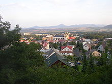
The city is located in northern Bohemia at the foot of the southern slope of the Ore Mountains .
Community structure
The town consists of the districts Bohosudov ( Mariaschein ), Fojtovice ( Voitsdorf ), Horní Krupka ( upper caterpillars ), Krupka ( caterpillars ), Maršov ( marshes ), Nové Modlany ( New Modlan ), Soběchleby ( Sobochleben ), Unčín ( Hohenstein ) and Vrchoslav ( Rosenthal ). Basic settlement units are Bohosudov, Dolní Krupka ( Untergraupen ), Dolní Maršov ( Unter Maršov ), Fojtovice, Habartice ( Ebersdorf ), Horní Krupka, Krupka-střed, Kyšperk ( Geiersberg ), Maršov, Maršov-sídlišté, Maršov-sídliště s, Maršiště Mohelnice ( Müglitz ), Nové Modlany, Pod státní silnicí, Soběchleby, U Svatého Prokopa, Unčín and Vrchoslav.
The municipality is divided into the cadastral districts of Bohosudov, Fojtovice u Krupky, Habartice u Krupky, Horní Krupka, Krupka, Maršov u Krupky, Mohelnice u Krupky, Nové Modlany, Soběchleby u Krupky, Unčín u Krupky and Vrchoslav.
Neighboring places
| Altenberg | Petrovice (Peterswald), Telnice (Tellnitz) | |
| Dubí (oak forest) |

|
Chlumec (Kulm), Přestanov (Priesten) |
| Proboštov (Probstau), Teplice (Teplitz-Schönau) | Srbice (Serbitz), Modlany (Modlan) | Chabařovice (Karbitz) |
history

The history of the city is closely linked to tin mining in the eastern Ore Mountains . The place Graupen is said to have existed as early as 1146 , the first documented mention as a city comes from the year 1330 . After the first pewter finds, barley flourished in the 13th and 14th centuries. Graupen Castle was built around 1300 to protect the mines and the trade route .
During the Hussite Wars in 1426 and 1429, in the Thirty Years' War and after numerous city fires, the city was destroyed several times. The parish church of the Assumption of Mary appears in the construction books of 1384 and 1394, but since it was destroyed in 1633, it has only existed in its current form since 1669.
In 1478 the city rights were confirmed by King Wladislaw II and a city coat of arms (coat of arms) was awarded. In 1497 the Graupener Schützengesellschaft (the oldest shooting society in Bohemia) was founded.
The city changed hands several times. In 1529 it fell through purchase and in 1547 again through forced delivery to the King of Bohemia Ferdinand I and thus became a royal free mountain town . In 1557 Thimo V. von Colditz sold the Graupen estate with the castle to Kaspar von Schönburg . In the 17th century it was owned by Messrs Sternberg and was acquired by Count Franz Clary-Aldringen in 1710 .
Due to war damage and increasing competition, mining declined in the 17th century and Graupen turned into an industrial town, where the mining of lignite began at the beginning of the 19th century . In the 20th century, wolframite , molybdenite and fluorspar were extracted .
On August 5, 1904, a major fire destroyed parts of the lower district.
After the First World War , Graupen was added to the newly created Czechoslovakia in 1919 . In 1930 there were 4,082 people living in Graupen. Of these, 3,282 were German Bohemians and 364 were Czechs. Due to the Munich Agreement Groats belonged from 1938 to 1945 for the district of Teplice , Region of Usti nad Labem , in the German Reich District of Sudetenland . The German residents were expropriated and expelled in 1945 . After 1945 many new citizens from Central Bohemia, Slovaks and Roma moved to this region. In 1956 ore mining was stopped, and in 1969 fluorspar mining was also discontinued.
Population development
Until 1945 Graupen was mostly populated by German Bohemia , which were expelled.
| year | Residents | Remarks |
|---|---|---|
| 1830 | 1408 | in 252 houses |
| 1857 | 3403 | on October 31st |
| 1869 | 2320 | |
| 1880 | 2904 | |
| 1890 | 3304 | |
| 1900 | 3543 | German residents |
| 1910 | 4102 | |
| 1921 | 3882 | |
| 1930 | 4092 | according to other data, 3882 inhabitants, of which 3356 are Germans |
| 1939 | 3912 |
| year | 1950 1 | 1961 2 | 1970 2 | 1980 3 | 1991 3 | 2001 3 | 2011 3 |
| Residents | 2943 | 8548 | 8320 | 9336 | 12620 | 13318 | 13147 |
Culture and sights

Museums
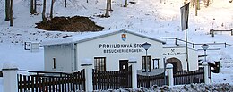
- Starý Martin visitor mine . The tunnel is a selected site for the proposed candidacy for theUNESCO World HeritageSite of the Ore Mountains Mining Region.
- Muzeum Krupka , Husitská 209/21
Buildings
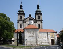
- Pilgrimage church in Mariaschein in the Bohosudov district
- Church of the Assumption ( Kostel Nanebevzetí Panny Marie ), built in the 13th century
- Former hospital church of the Holy Spirit ( Špitalni kostel sv. Ducha ), first mentioned in 1454
- St. Anna cemetery church ( Kostel sv. Anny ) from 1516
- Ruins of the St. Prokop Church
- Graupen Castle ( Hrad Krupka )
- Ruins of the Geiersburg ( Hrad Kyšperk ) from the 14th century.
Others
- Cross-border mining educational trail , starting at the town museum, via Graupen Castle to the Mining Museum Alter Martin ( Starý Martin ), further on to Komáří hůrka , with a view of České středohoří , downhill over the St. Wolfgang Chapel ( Kaple sv. Wolfganga ) to the Zinnwald ( Cínovec ), where it continues on the German side.
- A 2350 meter long cable car, built in 1952, leads from the Bohosudov district to the Mückenberg .
- Baroque statue of St. Francis Xavier from 1717
- Memorial stone for the ophthalmologist Professor Carl Ferdinand von Arlt
Trivia
The American newspaper Chicago Daily Tribune reported in the fall of 1885 of a murder in the Bohemian "Sobachleben" when the miner Anton Blaschek killed his wife in her sleep with an ax on her skull. He himself then put an explosive device in his mouth "and succeeded in blowing out his brains so completely that scarcely any remnants were found of his head." Fortunately, according to the report, the two children who slept with their mother stayed away from her Explosion unharmed.
sons and daughters of the town
- Ferdinand von Arlt (born April 18, 1812 in Obergraupen, Bohemia, † March 7, 1887 in Vienna), Austrian surgeon and ophthalmologist
- Joseph Dittrich (born April 25, 1794 in Marschen, Bohemia; † October 5, 1853), Roman Catholic clergyman in Upper Lusatia
Town twinning
- Geising (1995), Germany
literature
- Joachim Bahlcke , Winfried Eberhard, Miloslav Polívka (eds.): Handbook of historical places . Volume: Bohemia and Moravia (= Kröner's pocket edition . Volume 329). Kröner, Stuttgart 1998, ISBN 3-520-32901-8 .
- Hermann Hallwich : History of the mountain town of Graupen in Bohemia. Credner, Prague 1868, ( digitized version ).
Individual evidence
- ↑ http://www.uir.cz/obec/567639/Krupka
- ↑ Český statistický úřad - The population of the Czech municipalities as of January 1, 2019 (PDF; 7.4 MiB)
- ↑ http://www.uir.cz/casti-obce-obec/567639/Obec-Krupka
- ↑ http://www.uir.cz/zsj-obec/567639/Obec-Krupka
- ↑ http://www.uir.cz/katastralni-uzemi-obec/567639/Obec-Krupka
- ^ A b Johann Gottfried Sommer : The Kingdom of Bohemia . Volume 1: Leitmeritzer Kreis , Prague 1833, pp. 203–207.
- ↑ Yearbooks of the Bohemian Museum of Natural and Regional Studies, History, Art and Literature . Volume 2, Prague 1831, p. 197, paragraph 15.
- ↑ Statistical overviews of the population and livestock in Austria . Vienna 1859, p. 39, right column .
- ^ Meyers Großes Konversations-Lexikon 6th edition, Volume 8, Leipzig and Vienna 1907, p. 253 .
- ^ A b Michael Rademacher: German administrative history from the unification of the empire in 1871 to the reunification in 1990. Teplitz-Schönau district. (Online material for the dissertation, Osnabrück 2006).
- ^ Genealogy Sudetenland
- ↑ Historický lexikon obcí České republiky - 1869-2015. (PDF) Český statistický úřad, December 18, 2015, accessed on January 25, 2016 (Czech).
- ↑ Chicago Daily Tribune, November 29, 1885, p. 25


