
Chlumec u Chabařovic
| Chlumec | |||||
|---|---|---|---|---|---|
|
|||||
| Basic data | |||||
| State : |
|
||||
| Region : | Ústecký kraj | ||||
| District : | Ústí nad Labem | ||||
| Area : | 1287.8879 ha | ||||
| Geographic location : | 50 ° 42 ′ N , 13 ° 56 ′ E | ||||
| Height: | 235 m nm | ||||
| Residents : | 4,380 (Jan 1, 2019) | ||||
| Postal code : | 400 10-403 39 | ||||
| License plate : | U | ||||
| traffic | |||||
| Street: | Teplice - Děčín | ||||
| Railway connection: |
Děčín – Chomutov passenger traffic stopped in 2007 |
||||
| structure | |||||
| Status: | city | ||||
| Districts: | 6th | ||||
| administration | |||||
| Mayor : | Roman Hanusch (as of 2009) | ||||
| Address: | Krušnohorská 39 403 39 Chlumec |
||||
| Municipality number: | 568015 | ||||
| Website : | www.chlumec.cz | ||||
| Location of Chlumec in the Ústí nad Labem district | |||||

|
|||||


Chlumec (German Kulm ) is a city in Ústecký kraj in the Czech Republic .
geography
location
Chlumec is located five kilometers northeast of Krupka and belongs to the Okres Ústí nad Labem . The place at Chlumecký potok is located at the southern foot of the Eastern Ore Mountains below the Mravenčí vrch (557 m). Chlumec's local mountain is the Horka ( Kapellenberg ) on the northeastern edge of the village. Neighboring towns are Stradov and Přestanov in the west, Chabařovice and Český Újezd in the south and Žandov in the northeast.
Chlumec is located on state road 13 from Teplice to Děčín , from which state road 30 branches off to Ústí nad Labem on the outskirts . The road from Teplice to Ústí nad Labem is also part of the European route 442 . The Děčín – Chomutov railway line runs north .
To the southeast, the Ždírnický potok (Sernitz) flows around Chlumec. On the other side of the Sernitz there is a former lignite mining area with several remaining holes. The route of the D 8 motorway leads through this terrain . The industrial area around the old smelter and the sports airfield of Ústí nad Labem (LKUL) are located here.
Community structure
The town of Chlumec consists of the districts Český Újezd ( Bohemian Neudörfel ), Chlumec ( Kulm ), Hrbovice ( Herbitz ), Stradov ( Straden ), Střížovice ( Strisowitz ) and Žandov ( Schanda ), which also form cadastral districts.
history
Chlumec was first mentioned in 993 as a customs post together with Ústí nad Labem. In Chlumec, the Lausitzer Strasse and the Sorbenweg crossed important trade routes. In 1228, after the route of the Kulmer Steige was changed , Chlumec lost its function as a customs office. There is evidence of a church in Chlumec since 1352.
One of the most important owners of Chlumec is the Geisingen mining entrepreneur family Kölbel, who acquired the place from the Lords of Rybnice in 1486. In 1596, Peter Kölbel had a renaissance castle built. After the defeat in the Battle of White Mountain , the property of Peter Kölbel was confiscated and in 1623 lent to the Barons von Strahlendorf. In 1640, Chlumec passed to the Lords of Kolowrat and in 1758, by marriage, to the Counts of Thun and Hohenstein . In 1691, Johann Franz Graf Kolowrat-Krakowsky had a chapel built in the Italian Baroque style on the Horka on the occasion of the exemption from the outbreak of the plague of 1680, to which the village church laid out a way of the cross with 14 stations.
Around 1780 the old castle was replaced by a baroque new building, which included a castle brewery. The castle was surrounded by an English park.
In 1830 the Counts of Westphalen-Fürstenberg became owners of Chlumec. Josef Klement Graf von Westphalen had a family crypt built on the Horka under the chapel. In 1833 Kulm had 620 inhabitants. In 1847 a new church was built to replace the previous building from 1590. In 1875 the painter Ernst Gustav Doerell created his romantic painting of the castle pond with the Ore Mountains in the background. From the middle of the 19th century, Kulm was a municipality in the judicial district of Karbitz or in the district of Außenig . In 1932 Kulm had 1,091 inhabitants. After the end of the Second World War, the majority of the German residents were expelled by 1946 .
The historical spectacle Bitvy u Chlumce is held annually on the day of the battle of 1040 . The traditional Folk & Country music festival Chlumecký guláš also takes place in Chlumec .
The core town of Chlumec has a cadastral area of 411.79 hectares and as of December 31, 2008 a population of 3935. Since 2012, Chlumec has a new coat of arms. On August 21, 2012, Chlumec was raised to the city.
Wars and battles
The place has been the scene of major battles several times in the course of its history. The First Battle of Chlumec occurred in 1040 when Emperor Heinrich III. fought against the Bohemian Duke Břetislav I and was defeated at Chlumec. At that time Chlumec was a fortified place (fortress). The hill Horka is considered to be its location.
On February 18, 1126, the Second Battle of Chlumec took place. This time it was Duke Soběslav I who took over the army of Emperor Lothar III. and defeated Duke Otto II of Moravia . The exact location of the battlefield is not known. The battle could also have taken place on Lotarův vrch ( Lotterberg ) near Jílové .
In the Napoleonic Wars, Chlumec was the scene of a third battle. On August 29 and 30, 1813, French troops under Dominique Joseph Vandamme attempted to break through to Bohemia and were defeated in the Battle of Kulm by the allied troops under Friedrich Emil Ferdinand Heinrich von Kleist . The village was almost completely destroyed.
Fighting took place again in the last days of World War II when an SS supply unit was quartered in the castle . Anti- aircraft guns and heavy machine guns were stationed on the Horka in the palace grounds, and on May 8, 1945 they came under fire on a Soviet reconnaissance aircraft. A retaliatory bombing was launched that same day and a total of 86 people died. The castle, the mill and other houses were destroyed. In December 1971, duds from this attack were still found.
Development of the population
|
|
|
Attractions
- Chapel of the Holy Trinity from 1691 with the crypt of the von Westphalen-Fürstenberg family on the Horka mountain.
- Pillar with Pieta from the 18th century.
- "Ecce homo" pillar from the excavated village of Vyklice, erected in 1738. Moved to the church in Chlumec in 1980 together with a stone cross.
- St. Gallus Church in Kulm / Chlumec, built probably around 1130 and first mentioned in 1358. Rebuilt in 1590 under Peter Kölbel and added a tower. In 1847–1849 it was rebuilt in the neo-Romanesque style.
- Kulmer Chapel ( Chlumecká kaple ) at 663 m above the village in the Ore Mountains, built to commemorate the battle of 1126.
- Jubilee monument with memorial hall to the Battle of Kulm in 1813, erected on August 29, 1913 below the Horka.
- French memorial to the battle of 1813 in Straden, erected in 1913.
- Monument to General Vandamme in Žandov.
gallery
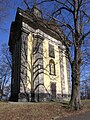
Trinity Chapel on Mount Horka

Anniversary memorial

St. Gallus Church

View of the church square

Kulmer Chapel in the Ore Mountains


Personalities
- Johann Georg Urbansky (1675–1738), sculptor and alabaster carver
Individual evidence
- ↑ http://www.uir.cz/obec/568015/Chlumec
- ↑ Český statistický úřad - The population of the Czech municipalities as of January 1, 2019 (PDF; 7.4 MiB)
- ↑ http://www.uir.cz/casti-obce-obec/568015/Obec-Chlumec
- ↑ http://www.uir.cz/katastralni-uzemi-obec/568015/Obec-Chlumec
- ↑ Historický lexikon obcí České republiky - 1869-2015. (PDF) Český statistický úřad, December 18, 2015, accessed on January 21, 2016 (Czech).
literature
- Raimund Klaus: The memorable events in the area of Teplitz and Kulm from 722 to 1838. Medau, Prag u. a. 1838, ( digitized version ).