Telnice
| Telnice | ||||
|---|---|---|---|---|
|
||||
| Basic data | ||||
| State : |
|
|||
| Region : | Ústecký kraj | |||
| District : | Ústí nad Labem | |||
| Area : | 1130.0067 ha | |||
| Geographic location : | 50 ° 44 ' N , 13 ° 56' E | |||
| Height: | 345 m nm | |||
| Residents : | 726 (Jan. 1, 2019) | |||
| Postal code : | 403 38 | |||
| License plate : | U | |||
| structure | ||||
| Status: | local community | |||
| Districts: | 3 | |||
| administration | ||||
| Mayor : | Jaroslav Doubrava (as of 2007) | |||
| Address: | Telnice 77 403 38 Telnice |
|||
| Municipality number: | 568295 | |||
| Website : | www.obec-telnice.cz | |||
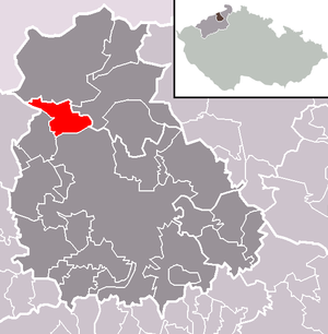
| Location of Telnice in the Ústí nad Labem district | ||||

|
||||
Telnice (German Tellnitz ) is a municipality in the Czech Republic . It is located nine kilometers northwest of Ústí nad Labem on the southern slope of the Eastern Ore Mountains.
geography
location
The 345 m above sea level. M. southwest of the Nollendorfer Höhe in the mountain valley of the Telnický potok ( Tellnitz ) located on the railway that runs from Děčín westwards at the foot of the Ore Mountains. The Dálnice 8 route runs one kilometer south .
Neighboring towns are Varvažov in the south, Žandov in the south-west, Liboňov in the west, Adolfov in the north-west and Nakléřov in the north-east.
Community structure
The municipality Telnice consists of the districts Liboňov ( Liesdorf ), Telnice and Varvažov ( Arbesau ), which at the same time also form cadastral districts. Basic settlement units are Adolfov , Liboňov, Telnice, U Staré Pošty, Varvažov and Zadní Telnice ( Hintertellnitz ).
Neighboring places
| Petrovice (Peterswald) | ||
| Krupka (pearl barley) |

|
Libouchec (Königswald) |
| Chlumec (Kulm) | Ústí nad Labem (Aussig) |
history
Tin mining has been in operation on the Tellnitz since 1371. Pits and soaps were built on the upper Rudný vrch. In addition to the hermaphrodite, iron, lead, copper, zinc and silver were also extracted.
Down the valley, scattered settlements of miners and woodcutters emerged on the territory of the Graupen rulership , of which Hintertellnitz was the oldest. In 1580 the Tellnitz valley was divided among several owners. As a result, the upper village of Hintertellnitz came under the rule of Schöbritz , while Mitteltellnitz belonged to Schönwalder and Vordertellnitz to Kulmer property.
The most important owners were the Geisingen mining entrepreneur family Kölbel, who owned large parts of Tellnitz together with Kulm and Schöbritz until 1627. In the Berní rula , 15 houses were designated for the entire Tellnitz valley, three of which were in desolation. Settlement of the valley increased, mills were built and in 1833 there were already 50 houses in which 246 people lived. Previously, during the Napoleonic Wars in 1813, the site was the scene of fighting at the Battle of Kulm and suffered severe damage.
Around 1840, Count Ledebur had a small castle built. At the time the patrimonial rule was replaced in 1850, Vorder- and Mitteltellnitz belonged to the Counts of Westphalia on Kulm and Schönwald and Hintertellnitz belonged to the Ledebur on Schöbritz. The settlement expanded down the valley and another settlement emerged on Arbesauer Fluren, which formed the Arbesauer district of Tellnitz. A small chapel was built there in 1860. In administrative terms, Tellnitz formed a municipality in the judicial district of Karbitz or in the district of Außenig from the middle of the 19th century .
In 1871 the Dux-Bodenbacher Eisenbahn started operations and a train stop was built between Vordertellnitz and Arbesau . In 1910 the Counts of Westphalen built a church. During this time, Vorder-, Mittel- and Hintertellnitz were united into one municipality of Tellnitz. Tellnitz was badly affected by the floods in the Eastern Ore Mountains in 1927 . Since the beginning of the 20th century, many of the Tellnitz people had been working in the granite quarries and in 1912 Tellnitz was made accessible by the electric tram from Aussig. Tourism also developed as a result. The population grew to around 3,000.
In 1960 Varvažov was incorporated. At that time, after mining had stopped, Telnice experienced a sharp decline in population. The core town consists of the localities Přední Telnice ( Vordertellnitz ), which forms the center of the place, while Prostřední Telnice ( Mitteltellnitz ) and Zadní Telnice ( Hintertellnitz ) today consist almost exclusively of holiday homes.
In the district of Zadní Telnice there is a winter sports center, there are seven ski lifts in operation. The Telnice Ski Club is the second largest in the Czech Republic. In 1965, a snow lance ( snow cannon ) was used for the first time under socialism , today the ski area is prepared with snow-making processes and piste equipment.
A used double chairlift from Switzerland has been operating in the ski area since January 2014, and the Garaventa ( Doppelmayr ) system was dismantled in the Lenzerheide ski area .
Attractions
- neo-Gothic chapel and Ledeburg crypt
Sports
There is an amateur soccer team with FK Spartak Telnice .
Web links
- Website of the municipality (Czech)
Individual evidence
- ↑ http://www.uir.cz/obec/568295/Telnice
- ↑ Český statistický úřad - The population of the Czech municipalities as of January 1, 2019 (PDF; 7.4 MiB)
- ↑ http://www.uir.cz/casti-obce-obec/568295/Obec-Telnice
- ↑ http://www.uir.cz/katastralni-uzemi-obec/568295/Obec-Telnice
- ↑ http://www.uir.cz/zsj-obec/568295/Obec-Telnice
- ↑ http://www.skilifte-telnice.de/
- ↑ http://skilifte-telnice.de/baustellentagebuch//
- ↑ http://fkspartaktelnice.webnode.cz/

