Dolní Zálezly
| Dolní Zálezly | ||||
|---|---|---|---|---|
|
||||
| Basic data | ||||
| State : |
|
|||
| Region : | Ústecký kraj | |||
| District : | Ústí nad Labem | |||
| Area : | 357,2014 ha | |||
| Geographic location : | 50 ° 36 ' N , 14 ° 3' E | |||
| Height: | 170 m nm | |||
| Residents : | 576 (Jan. 1, 2019) | |||
| Postal code : | 403 01 | |||
| License plate : | U | |||
| traffic | ||||
| Street: | Lovosice - Ústí nad Labem | |||
| Railway connection: | Railway line Prague – Děčín | |||
| structure | ||||
| Status: | local community | |||
| Districts: | 1 | |||
| administration | ||||
| Mayor : | Miroslav Suchý (status: 2009) | |||
| Address: | Mírové náměstí 8 403 01 Dolní Zálezly |
|||
| Municipality number: | 567931 | |||
| Website : | www.dolni-zalezly.cz | |||
| Location of Dolní Zálezly in the Ústí nad Labem district | ||||

|
||||
Dolní Zálezly (German Salesel ) is a municipality in the Czech Republic . It is located seven kilometers south of the city center of Ústí nad Labem and belongs to the Okres Ústí nad Labem .
geography
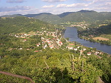
Dolní Zálezly extends in the valley of the Elbe through the Bohemian Uplands on the left side of the river below the confluence of the Moravanka brook. To the north rise the Skalky (454 m), Černová (503 m) and the Vaňovský vrch (561 m), in the northeast of the Pahorek (379 m) and Matrý (597 m), east of the Varhošť (639 m), in the south of the Trabice (429 m) and Deblík (459 m), southwest of the Výsluní (364 m), in the west of the Dubický kopec (358 m) and Smrčník (368 m).
Neighboring towns are Podlešín and Chvalov in the north, Němčí and Čeřeniště in the northeast, Kolibov in the east, Sebuzín in the southeast, Církvice and Dubičky in the southwest, Dubice and Moravany in the west and Stebno in the northwest.
history
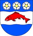
The first written mention of the village took place in 1057 in the founding document of the Leitmeritz chapter. In 1226 Ottokar I. Přemysl gave part of the village to the Doksany monastery . In 1273 Ottokar II Přemysl left the fishing rights granted to the sovereign to the monastery. In 1357, in addition to the monastic part, part of the place Špik von Hradec, another part belonged to the Syrso from Dubice. In 1487 the Lords of Colditz on Krupka acquired the share of the monastery. In 1578 the city of Aussig bought this part. The other part of the village belonged to the rule Groß Tschochau since 1579 . The Aussiger share was sold to the city of Leitmeritz in 1610 and attached to the municipal estate of Keblitz . In 1633 the foot mail connection from Dresden to Prague was started via Salesel, which ran as mounted mail in 1652. In the berní rula of 1654, two farmers, 16 small farmers and twelve gardeners are identified for Salesel. In 1752 carriage traffic began on the Dresden-Prague postal route. At this time, the Prager Strasse , which had previously run from Aussig via Stöben and Wellmin through the mountains , was probably relocated to the Elbe Valley. In 1755 the old Prager Strasse had lost its importance. In 1787 there were 72 houses in Salesel. On April 25, 1815, a large fire destroyed 13 houses. Until the middle of the 19th century, the original character of the village as a round was preserved. Because of its protected south-facing slope, Salesel was an important fruit growing area. Mainly cherries, apricots, peaches and strawberries were grown. The place was also known for its salmon fishing in the Elbe. Together with Perštejn , Salesel was called the Bohemian Meran . Between 1847 and 1851 the Imperial and Royal Northern State Railroad built the railway from Prague to Dresden through the Elbe Valley.
After the abolition of patrimonial Salesel / Záleszly formed from 1850 a political municipality in the judicial district or district . In 1887, 471 people lived in the 83 houses of Salesel. At this time Salesel gained the reputation of a summer resort in the course of the tourist development of the low mountain range and became the starting point for excursions to the Dubitzer church, Müllerstein and the Doerell view. By the First World War, the place was greatly expanded and extended for three kilometers along the Elbe. In 1921 Salesel consisted of 156 houses and had 749 inhabitants. The largest company was the Glassand- u. Salesel kaolin works. To distinguish it from the other village of Zálezly, located on the right Elbe in the mountains and belonging to the Leitmeritz district, the place was given the name Dolní Zálezly around 1930 , while the other place was henceforth called Horní Zálezly . The municipality of Salesel had 779 inhabitants in 1930, most of whom were Germans. After the Munich Agreement , the community was added to the German Reich in 1938 and belonged to the Aussig district until 1945 . In 1939 the community had 750 inhabitants. In 1945 Dolní Zálezly returned to Czechoslovakia and the German residents were expelled . In 1948 the community was assigned to the Okres Ústí nad Labem-okolí and in 1961 again to the Okres Ústí nad Labem . Between 1961 and 1971 Chvalov was incorporated and was then attached to Stebno .
Local division
No districts are designated for the municipality of Dolní Zálezly.
Attractions
- Chapel of St. Anna, on the village square, built in 1780
- Mlynářův kámen, observation and climbing rock, west of the village
- Statue of St. John of Nepomuk
- Ecce Homo statue
- Station, built 1850–1851 according to plans by Alois Negrelli von Moldelbe


