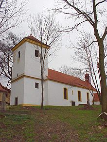
Chuderov
| Chuderov | ||||
|---|---|---|---|---|
|
||||
| Basic data | ||||
| State : |
|
|||
| Region : | Ústecký kraj | |||
| District : | Ústí nad Labem | |||
| Area : | 1534.6398 ha | |||
| Geographic location : | 50 ° 42 ' N , 14 ° 3' E | |||
| Height: | 340 m nm | |||
| Residents : | 1,071 (Jan 1, 2019) | |||
| Postal code : | 400 01 - 403 33 | |||
| License plate : | U | |||
| traffic | ||||
| Street: | Ústí nad Labem - Velké Chvojno | |||
| structure | ||||
| Status: | local community | |||
| Districts: | 6th | |||
| administration | ||||
| Mayor : | Jan Novotný (as of 2009) | |||
| Address: | Chuderov 63 400 02 Ústí nad Labem 2 |
|||
| Municipality number: | 568023 | |||
| Website : | www.chuderov.cz | |||
| Location of Chuderov in the Ústí nad Labem district | ||||

|
||||
Chuderov (German Groß Kaudern , also Großkaudern ) is a municipality in the Czech Republic . It is located four kilometers north of the city center of Ústí nad Labem and belongs to the Okres Ústí nad Labem .
geography
Chuderov is located in the left Elbe part of the Bohemian Central Uplands on the upper reaches of the Chuderovský creek. Radešín ( Gratschen , 550 m) rises to the northeast, Farský vrch (520 m) to the east, Dobětická výšina (459 m) to the southeast, Brandtova výšina ( Brand , 436 m) to the south and the Čepek (477 m) to the northwest. and Ostroh (454 m).
Neighboring towns are Chuderovec in the north, Radešín in the north-east, Sovolusky, Ryjice and Žežice in the east, Mlýniště, Krásné Březno and Dobětice in the south-east, Ústí nad Labem , Stříbrníky and Kočkov in the south, Nový Kočtěžkov, Ovčarna and Severníštwest in the west as well as Studánka, Strážky and Neznabohy in the northwest.
history
The first written mention of the Chuderov manor took place in 1348. Between 1375 and 1400 the fortress belonged to Ejvan von Chuderov. Jan Tlumek followed him. The Šesták family owned Chuderov from 1429 to 1482. In 1527 Johann von Lungwitz acquired the Chuderov farm and the neighboring Schöbritz estate. In 1546 his son Albrecht von Lungwitz Chuderov inherited. Wolf Soldan von Steinbach (Volf Žoldan ze Štampachu), who had acquired the estate in 1569 through his marriage to Margarethe von Lungwitz, bought the Schöbritz rule in 1580 and united Chuderov with Schöbritz. Schöbritz later belonged to Johann Hermann Kölbel von Geysing, who had married Esther von Steinbach. After the Battle of the White Mountain in 1623, Kölbel was punished with the loss of a third of his property. His wife Esther received the farm and the village of Chuderov back. In the berní rula from 1654 10 farms are shown for Chuderov. The Chuderov estate was divided into tenants in 1794 and the Meierhof was extinguished. Between 1834 and 1852 the settlement Auf der Not , later called Neu Gatschken , was built in the corridors of the courtyard . Chuderov was parish at Lake Seat.
After the abolition of patrimonial Großkaudern / Chuderov formed from 1850 with the district Gatschken / Kočkov including Neu Gatschken and the sheep farm a political municipality in the judicial district of Außenig or district of Außenig . In 1921 the village consisted of 79 houses and had 715 inhabitants, most of whom were Germans. At that time, the Schäferei settlement consisted of nine houses. In 1930 726 people lived in the community. After the Munich Agreement , Groß Kaudern was added to the German Reich in 1938 and belonged to the Aussig district until 1945 . In 1939 the community had 716 inhabitants. In 1945 Chuderov returned to Czechoslovakia and the German residents were expelled . In 1948 the community was assigned to the Okres Ústí nad Labem-okolí. Since 1961 Chuderov has belonged again to the Okres Ústí nad Labem , at the same time Chuderovec (with Neznabohy), Žežice (with Mlýniště) and Sovolusky were added as districts. Kočkov and Nový Kočkov were transferred to Ústí nad Labem in the same course. In 1980, Radešín, Lipová and Libov were incorporated.
Local division
The municipality Chuderov consists of the districts Chuderov ( Groß Kaudern ), Chuderovec ( Klein Kaudern ), Libov ( Lieben ), Lipová ( Spansdorf ), Radešín ( Gratschen ) and Žežice ( Seesitz ), which also form cadastral districts. Basic settlement units are Chuderov, Chuderovec, Kozí Stráň, Libov, Lipová, Radešín, Sovolusky ( Soblitz ) and Žežice. The settlements Mlýniště ( Leinisch ), Neznabohy ( Niesenbahn ), Ovčárna ( sheep farm ) also belong to Chuderov .
Attractions
- Church of St. Peter and Paul in Žežice, traceable since 1352
- Church of St. Martin in Lipová, built in the 15th century
- Erbenova vyhlídka observation tower ( Alexander Erben-Warte ) on Erbenova výšina, south of the village, inaugurated on July 1, 1933
- Chapel in Radešín, built in the first half of the 19th century
- Chapel of St. Trinity in Neznabohy, built in 1821
Former architectural monuments
- Chapel of St. Johannes von Nepomuk in Chuderov, the baroque building from the 18th century was demolished in 1967
- Baroque crucifixion column in Ovčárna, destroyed in 1950
Web links
Individual evidence
- ↑ http://www.uir.cz/obec/568023/Chuderov
- ↑ Český statistický úřad - The population of the Czech municipalities as of January 1, 2019 (PDF; 7.4 MiB)
- ↑ http://www.uir.cz/casti-obce-obec/568023/Obec-Chuderov
- ↑ http://www.uir.cz/katastralni-uzemi-obec/568023/Obec-Chuderov
- ↑ http://www.uir.cz/zsj-obec/568023/Obec-Chuderov


