
Varhošť
| Varhošť | ||
|---|---|---|
 Lookout tower on the Varhošť |
||
| height | 638.9 m nm | |
| location | Czech Republic | |
| Mountains | Central Bohemian Uplands | |
| Coordinates | 50 ° 35 '25 " N , 14 ° 6' 2" E | |
|
||
| Type | Kegelberg | |
| rock | basalt | |

The Varhošť (German Aarhorst , 639 m) is a little prominent mountain in the Bohemian Central Uplands in the Czech Republic . Only on its west and north side is there a steep, rocky flank that extends down to the Elbe . There is a 14 m high observation tower built in 1972 on the summit. Its extraordinary construction with the self-supporting central column is remarkable.
Location and surroundings
The Varhošť is located in the right Elbe part of the Bohemian Central Uplands, 5 km north of Litoměřice ( Leitmeritz ). Directly on the Elbe at the foot of the mountain lies the community of Sebuzín ( Sebusein ), once widely known as a resort. On the south side of the mountain is the small village of Kundratice ( Kundratice ). The former Schlängelweg , a historical hiking trail through the Bohemian Central Uplands, ran along here.
view
In old travel guides you can read that you can see the course of the Elbe in ten different places. In fact, the Elbe can be seen in eight different sections. Impressive is especially the view down to Střekov ( Schreckenstein ). While to the east the ridge of the Dlouhý vrch ( Long Mountain ) blocks the view, one looks to the west to the mountains of the western Bohemian Central Uplands with Kletečna ( Kletschen ) and Milešovka ( Milleschauer ). In the south, the wide Elbe valley is visible.
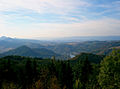
View to the northwest

View to the west
(→ Milešovka )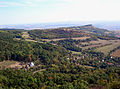
View to the south
(→ Hradiště u Hlinné )


Paths to the summit
- Most of the visitors to the mountain begin their ascent from Kundratice today. The steep ascent to the summit takes place on a hiking route marked in yellow .
- The Elbe village of Sebuzín is also a good starting point. From there it is possible to ascend via a green or yellow marked hiking route.