Hradiště u Hlinné
| Hradiště u Hlinné | ||
|---|---|---|
| height | 545 m nm | |
| location | Czech Republic | |
| Mountains | Central Bohemian Uplands | |
| Coordinates | 50 ° 34 '8 " N , 14 ° 6' 50" E | |
|
|
||
| rock | basalt | |
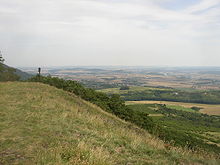
The Hradiště u Hlinné (German: Radischken , 545 m) is a striking basalt mountain in the Bohemian Central Uplands on the right Elbe, not far from the municipality of Hlinná .
Location and surroundings
The Hradiště u Hlinné rises about four kilometers north of Litoměřice ( Leitmeritz ). Directly at the foot of the mountain are the community Hlinná and the small settlement Mentaurov ( Mentau ). In the north there is a wide, barely forested mountain plateau, which extends over to the neighboring mountain Holý vrch u Hlinné ( Kundratitzer Kahleberg ).
natural reserve
The upper part of the mountain has been placed under state protection as a nature reserve over an area of 5.3 hectares since 1954 . Noteworthy is the declining occurrence of the Pasque Flower ( Pulsatilla patens ) and the endemic Bohemian Pasque Flower ( Pulsatilla pratensis bohemica ) in the dry grassland on the west and south sides. In the shade of the forest on the east side and on the summit plateau there are extensive populations of liverwort ( Hepatica nobilis ), which is a pale variety here.
view
Especially in a southerly direction, a wide view from the summit over the wide Elbe lowlands and the mountains of the southern Bohemian Central Uplands is possible. Striking elevations in the field of vision are above all Radobýl ( Radobil ), Hazmburk ( Hasenburg ) and Lovoš ( Lobosch ). In the foreground the view falls over the extensive buildings of the old episcopal town Litoměřice.
Paths to the summit
The summit can be reached on a yellow path from Hlinná, from the east from the Mentaurov settlement.


