Radobýl
| Radobýl | ||
|---|---|---|
|
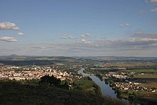
Radobýl of Litoměřice seen |
||
| height | 399 m | |
| location | Czech Republic | |
| Mountains | Central Bohemian Uplands | |
| Coordinates | 50 ° 31 '48 " N , 14 ° 5' 40" E | |
|
|
||
| Type | Kegelberg | |
| rock | basalt | |
The Radobýl (German: Radebeule , also Radobil ) is one of the most striking cone mountains in the southern Bohemian Central Uplands in the Czech Republic . The bare, almost woodless mountain is particularly impressive from the south with its bell-shaped, rugged shape. The rare dry grass vegetation on the south side is protected as a natural monument .
Location and surroundings
The Radobyl is located in the right Elbe part of the Bohemian Central Uplands and forms one of the gate posts of the Porta Bohemica about 3 km west of Litoměřice (Leitmeritz) . Directly at the foot of the mountain on the south side is the municipality of Žalhostice (Tschalositz) , which, like the neighboring Velké Žernoseky (Großtschernosek), is known for its viticulture . During the Second World War, the Richard underground arms factory was located under the ridge north of the mountain . The underground rooms are now used as a repository for low- level radioactive waste , see Richard (Czech Republic) .
geology
The upper part of the mountain consists of basalt , which was mined in the quarry on the west side by the Chalositz basalt works until the 1950s . The lying, curved and standing basalt columns are among the most beautiful in the Bohemian Central Uplands. The base of the mountain is formed by sediments of the chalk , here mainly planar sandstone .
Floristic features
Typical for all mountains of the southern Bohemian Central Uplands are the dry grasslands on the sunlit southern sides. These areas are home to many plants that are rare for Central Europe and come from the steppes of Southeast Europe.

Culture
The summit was one of the favorite places of the writer Karel Hynek Mácha . On October 23, 1836 he saw a fire in Litoměřice from here. He ran downstairs to put it out. During the extinguishing process, he drank water from a well. Probably because of this, he died of typhoid on November 6th .
view
The view is very comprehensive. In the south the wide Elbe valley spreads out, dominated by the Říp ( Georgsberg ) and the Hazmburk ( Hasenburg ). To the west, the view sweeps over the Elbe breakthrough at Porta Bohemica into the western Bohemian Central Uplands with Lovoš ( Lobosch ), Kletečná ( Kletschen ) and Milešovka ( Milleschauer ). The saddle-shaped Sedlo ( Geltschberg ) rises in the northeast .
Paths to the summit
- Over the hill leads a yellow-marked trail, which in Litoměřice ( Leitmeritz starts) and leads into Elbdorf Žalhostice. A short, steep turn-off leads from this path to the summit.
- A convenient access for an ascent, with parking for motorists, is in the saddle north of the Radebeule on the road from Litoměřice to Michalovice. On the summit there have always been summit crosses that can be seen from afar, the first cross existed as early as 1622. The iron cross that was erected today in the early 1990s is the eighth in a row.
literature
- Peter Rölke (Ed.): Hiking and nature guide Bohemian Central Mountains. Berg- und Naturverlag Rölke, Dresden 2008


