Nakléřov
| Nakléřov | ||||
|---|---|---|---|---|
|
||||
| Basic data | ||||
| State : |
|
|||
| Region : | Ústecký kraj | |||
| District : | Ústí nad Labem | |||
| Municipality : | Petrovice | |||
| Area : | 495.4465 ha | |||
| Geographic location : | 50 ° 45 ' N , 13 ° 59' E | |||
| Height: | 680 m nm | |||
| Residents : | ||||
| Postal code : | 403 37 | |||
| License plate : | U | |||
Nakléřov (German Nollendorf ) is a basic settlement unit of the Petrovice municipality in Ústecký kraj in the Czech Republic . It belongs to the district of Krásný Les .
Geographical location
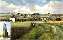
The place lies on the ridge of the Eastern Ore Mountains at an altitude of about 680 m. Geologically speaking, the Ore Mountains end west of Nakléřov , the underground rocks ( gneiss , granite ) merge into the sandstones of the Elbe Sandstone Mountains . The small settlement lies in a basin west of the Nakléřovská vyšina (Nollendorfer Höhe). After a few kilometers, the village stream flows into the Jílovský potok (Eulabach), which rises immediately north of Nakléřov.
history
The place was founded after the discovery of smaller gold and silver deposits around 1100 at about the same time as the tin forest and pearl barley . The first documentary mention took place in 1382 as Naklerzow . Other spellings were Nagleri villa (1405), Noildorf (1551), Nolndorf (1594) and Nahlendorf (1604). Despite the ore finds, mining seems to have had little importance, since the place was laid out as a forest hoof village, which indicates agriculture as the economic basis of the village community.
The ores were initially only soaped , and later built the pit Blessing God Mine and other smaller mines . The nearby Zechberg (792 m above sea level ) got its name from this mine. Silver , iron ore , copper , lead and zinc were extracted in these mines .
In 1216 Nollendorf was a church village and belonged to the Bilin diaconate . Jungferndorf and Mittel-Tellnitz once belonged to the parish of Nollendorf. The lords of Lungwitz became owners of Nollendorf in 1310, and in 1404 Wenzel von Wartenberg became the owner of this community through an exchange.
Due to its location on the well-known salt and military road from Saxony to Bohemia over the Nollendorfer Pass (672 m above sea level), the place repeatedly suffered from troop movements in times of war. After the devastation of the Thirty Years' War , 19 of the 35 houses were uninhabited in 1654. Parts of the village were also destroyed in the course of the Battle of Kulm in 1813.
For the population, which had been growing since the 18th century, agriculture offered only limited opportunities to earn a living, so that the inhabitants u. a. earned their living by weaving and knitting. The men also often worked as craftsmen and construction workers in other places. In the course of industrialization in the second half of the 19th century, some of the residents moved to the workplaces of the booming North Bohemian lignite mining or emigrated. Industrial companies also offered employment opportunities in the surrounding villages such as Petrovice u Chabařovic (Peterswald) and Tisá (Tissa). In administrative terms, Nollendorf formed a municipality in the judicial district of Karbitz or in the district of Außenig from the middle of the 19th century .
At the beginning of the 20th century, tourism gained in importance. In 1903 the Reichsstraße Teplitz - Pirna , the old post road , which runs through the town, was completed.
Population and size development
- 1654: 16 inhabited and 19 deserted houses
- 1787: 72 inhabited houses
- 1860: about 700 inhabitants
- 1880: 452 inhabitants, 96 inhabited houses
- 1900: 84 houses
- 1907/08: 357 inhabitants, 84 houses
- 1939: 310 inhabitants in 84 households
Notoriety
The place became famous through the Wars of Liberation and the Battle of Kulm and Nollendorf on August 30, 1813. In Berlin-Schöneberg , Nollendorfplatz and Nollendorfstrasse are named after this place.
Attractions
On the Nollendorfer Höhe in 1913, on the occasion of the 100th anniversary of the battle, the Kaiserwarte (named after Emperor Franz Josef I of Austria ) was built. In 1923 the 21 m high observation tower was renamed Carl-Weis-Warte . On January 29, 1944, the tower collapsed during a snow storm, and its remains were removed after 1950.
The Krušnohorská lyžařská magistrála , which begins in the Western Ore Mountains and leads via Cínovec and Komáří vížka (mosquito turrets), ends in Nakléřov .
Web links
- Nollendorf in the Ore Mountains on peterswald.org


