
Dresden-Teplitzer Poststrasse

The old and new Dresden-Teplitzer Poststraße belong to the Ore Mountains passes and form part of the old system of paths known as the Kulmer Steig , which led from the Dresden Elbe Valley over the Eastern Ore Mountains to Bohemia . Today, the old Dresden-Teplitzer Poststrasse in its Saxon section is considered to be the most complete historical traffic connection with preserved post mile columns .
course

The routing of both streets began in Dresden at the Pirnaischer Tor , today's Pirnaischer Platz . The route led over the Pirnaische Straße past the Great Garden to Strehlen .
The Alte Dresden-Teplitzer Poststraße ran from the Strehlen town center of Altstrehlen further out of town along the Dohnaer Straße . Thus, its course in the Dresden city area is identical over large sections with today's state road 172 (former federal road 172 ). Between Lockwitz and Kleinluga , the S 172 leaves the old Poststrasse route, which bridges the Maltengraben as the Alte Landstrasse and then continues as Lockwitzer Strasse over the Lugberg to Dohna . The route led from here via Köttewitz , Niederseidewitz , Nentmannsdorf , Göppersdorf , Börnersdorf , Breitenau and Fürstenwalde to the Bohemian border. In Bohemia, it first led on over the ridge plateau near Ebersdorf (Habartice) to the Geiersberger Pass , and then downhill past the Geiersburg (Kyšperk) past the Mariaschein (Bohosudov) monastery and Soborten ( Sobědruhy ) to Teplice (Teplice) .
The Neue Dresden-Teplitzer Poststrasse led from Dresden directly to Pirna and from here via Zehista , Cotta , Berggießhübel , Gottleuba and Hellendorf to today's Bahratal border crossing . Here the road reached over Peterswald (Petrovice) at 680 m above sea level. NN located Nollendorfer pass , from which the mountain descent over Tellnitz (Telnice) and Kulm ( chlumec done) to Teplitz (Teplice).
history

Country roads like these two post roads emerged as connecting roads between the countries in the Middle Ages . They very often use connections that were already used in the early days of trade by traders and travelers on foot, on horseback or in carriages . The most scenic routes were selected, especially when it came to crossing rivers and mountains .
At first the salt route led as a trade route across the Ore Mountains from Prague to Halle (Saale) . It went through Teplitz and on the old Poststrasse, which was based on the Kulmer Steig , over the Geiersberg, past the “Goldammerkreuz” to Ebersdorf and from there to the “Black Cross” (both erected before 1785), to Müglitz and on to Saxony .
The result was a road system which, depending on the sub-goal, has different branches. Apart from the aforementioned post-roads are in the middle and Osterzgebirgischen nor the Müglitztalstraße portion (extending in the valley of Müglitz of Dohna about glassworks , Dittersdorf , Baerenstein , Lauenstein to Geising ) and the comb (between the Altenberg , Neuhermsdorf , Hermsdorf / Erzgeb. , Reichenau , Hartmannsdorf , Frauenstein , Rechenberg-Bienenmühle and Holzhau ) should be mentioned.
The roads were expanded further in the period that followed. From 1803 the connection from Teplitz to Prague began, and from 1810 the new Dresden-Teplitz Poststrasse was completely expanded. With industrialization , a significant change in the meaning of the two postal routes began in the mid-19th century. On the one hand, traffic shifted from the high roads to the newly built valley roads. The previously insignificant mountain crossing at Zinnwald was upgraded through the construction of the Müglitztalstrasse (from 1846) and the expansion of the Dresden - Dippoldiswalde - Schmiedeberg - Altenberg link (from 1842), while the neighboring Alte Dresden-Teplitzer Poststrasse over the pass at the Geiersburg (Kyšperk) became deserted and the border crossing near Fürstenwalde was closed in 1860.
With the construction of the Dresden-Bodenbacher Eisenbahn (1848/51), the importance of the New Dresden-Teplitzer Poststrasse as a supra-regional connection also declined, but the loss of importance was not as drastic as with the old Dresden-Teplitzer Poststrasse.
Labelling
The efforts to promote the postal and transport system, which were pushed by the Saxon elector Augustus the Strong at the beginning of the 18th century, required the surveying and mapping of the road system in Saxony. Adam Friedrich Zürner (1679–1742), who was later appointed Land and Border Commissioner for the Electoral Saxony region, was entrusted with this work from 1712 . As a result of his land surveying over several years, the elector ordered all important roads and postal connections to be marked by means of stone posts in 1721 . The distance columns set up in front of the city gates and on the marketplaces as well as the whole and half milestones set up on the roadside indicated the distances to the nearest important places on the postal route. The quarter milestones also marked the course of the road.
New Dresden-Teplitzer Poststrasse
.jpg)
The Neue Dresden-Teplitzer Poststrasse was probably already measured by Zürner in 1722, three years before the Alte Dresden-Teplitzer Poststrasse. In a comparison of the two roads, this speaks for the greater importance of the path leading to Bohemia via Peterswald (Petrovice) and the Nollendorfer Pass . As early as 1723, the connection was marked using full and half mile columns and quarter milestones. In Berggiesshuebel and Bad Gottleuba post mile columns were erected. These two pillars are the only remaining landmarks from Zürner's time today. All other columns and stones probably fell victim to the expansion of the road, which began in 1810. The royal Saxon milestones near Dohma and Cotta that are still preserved along the road refer to the new mile length introduced in 1840 . The border column on the round part in Bahratal is a specialty. Although it still shows the distance information in league hours as in Zürner's time , the year 1820 is carved in. The column is demonstrably set much earlier, because it is on a mile sheet recorded in 1784 already noted as "border pillar".
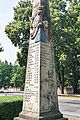
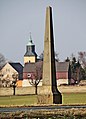
Coat of arms and distance block of the Saxon distance column Berggießhübel
_2006-07-24.jpg)
_2007-09-21.JPG)
_2006-03-24.jpg)
_-_Grenzs%C3%A4ule_am_Rundteil_(01-2).JPG)
Old Dresden-Teplitzer Poststrasse
Zürner measured the Alte Dresden-Teplitzer Poststrasse in 1725. Four years later, the erection of the pillars and milestones between Dresden and the Saxon-Bohemian border began. By 1732, 19 such markings were set along the road. Starting today and including the distance column in Dohna up to the state border, all 14 stones can be found again without any gaps. This makes the Old Dresden-Teplitzer Poststrasse in its Saxon section the most complete historical traffic connection with post mile columns and milestones. Your path markings and the following six sections of originally preserved path sections are now under monument protection :
- Hollow road at the Eulmühle near Niederseidewitz
- Field path at the Erlichtteich near Göppersdorf
- Dirt road between Göppersdorf and Börnersdorf
- Forest path through the Harthewald between Breitenau and Fürstenwalde
- Field path to the Black Cross near Fürstenwalde
While the loss of the distance columns and milestones that were once between Dresden and Dohna is mainly due to the urban growth in the upper Elbe valley , the losses of the markings that were formerly still between Dohna and the border are more likely to be related to acts of war and / or agricultural and forestry measures traced back.
The following distance, full-mile, half-mile pillars and quarter milestones still exist along the Alte Dresden-Teplitzer Poststrasse:
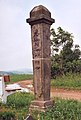
- Dohna : There is a post mile column from 1732 on the market. It marks the beginning of the ascent of the Alte Dresden-Teplitzer Poststrasse to the heights of the Eastern Ore Mountains. Quarter milestone No. 7 from 1732 is on the road in the direction of Köttewitz. This first milestone still preserved on Poststrasse was added after 1910 and restored in 1956.
- Meusegast : On the edge of the road leading from Köttewitz to the Seidewitztal, below Meusegast, there is the whole milestone No. 8 from 1729. It was last restored in 1997 and set back a little from the road. During the construction work on the immediately adjacent A 17 , the column was surrounded by a wooden corset for a long time and was thus protected against possible damage. The former top of the column is located in the Eastern Ore Mountains Museum at Lauenstein Castle .
- Niederseidewitz : On the slope of the narrow ravine that climbs from the Seidewitztal past the Eulmühle to the plateau between Seidewitz and Bahra, before the entrance to Niederseidewitz is quarter milestone No. 9 from 1729. It was erected again in 1965 and repaired in 1983 and 2012 Originally rotated again, secured and repositioned.
- Nentmannsdorf : The half-mile column No. 10 from 1729 is in front of the town entrance. It was erected again in 1968 after the head and base were added, after the shaft had been excavated a year earlier during road construction work. After an accident, the column was stored and the site was built over during the construction of the A 17 Dresden-Prague. The base and the foundation were lost. The column was reconstructed on behalf of DEGES and put up again in 2012 at a bus stop nearby.
- Göppersdorf : North of the village at Ehrlichtteich is the all-mile pillar no.12 from 1729 . It was rebuilt in 1965 from fragments found in the pond in 1958. The column broke apart in 1986 but was put back up. An original part that is no longer used is located in Kuckuckstein Castle in Liebstadt .
- Börnersdorf : At the northern entrance to the village, on the road to Göppersdorf-Wingendorf, there is half-mile column no. 14 from 1732. It was only rediscovered in 1985 and erected in 1989. After the housing was removed as part of the construction of the A 17 , the column fell over and broke. The column was reconstructed on behalf of DEGES and put up again in 2012. At the southern exit of the village in the direction of Breitenau is the quarter milestone no. 15, which was also set in 1732. In 1955, this stone was freed from smears and scratches and returned to its original position at right angles to the street; Another restoration took place in 1978 after being damaged in a traffic accident.
- Breitenau : On the road from Breitenau to Liebenau there is a full-mile column from 1732. The column is the 16th marker on the Old Dresden-Teplitzer Poststraße when viewed from Dresden. In 1889, on the occasion of the Wettin Festival (800 years of Wettin as ruler of the Margraviate of Meißen ), a restoration was carried out in which the fallen tip was replaced and the column was whitewashed. In 1956 cracks were repaired and the weathered inscriptions were hewn down. Another restoration took place after the column was damaged in a traffic accident in 1985. Today there is a replica and the original is on display in the Breitenau church.
- Liebenau : At the northern entrance of the Harthewald forest is quarter milestone No. 17, which was erected in 1732. It shows a post horn upside down on both sides. The stone broke in 1955 when a tractor crashed, but was repaired and re-erected in the same year by the sculpting company Kajer from Berggießhübel . Today's stone is a copy. The original is in the Osterzgebirgsmuseum Schloss Lauenstein .
- Fürstenwalde : The half-mile column No. 18 from 1729 is on the road coming from Liebenau . It fell over at the beginning of the 19th century. After fragments had been found in the 1950s and 1960s, the column was re-erected in 1967. Until 2012 it was the last remaining waymarking before the Saxon-Bohemian border.
Three non-existent quarter milestones at Borna-Gersdorf (location on the road from Laurich to Herbergen), Göppersdorf-Wingendorf (location on the Feldweg motorway bridge) and Fürstenwalde (location at the junction to the Black Cross ) including the explanatory boards next to all the Saxon post mile columns from Dohna to Fürstenwalde were prepared or set up as a remaining service by DEGES according to the planning approval decision for the federal motorway 17 until June 11, 2012 .
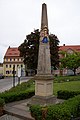
Distance column on the market in Dohna

Quarter milestone No. 7 in Dohna

Full mile column no. 8 near Meusegast

Quarter milestone No. 9 near Niederseidewitz

Half-mile pillar no.10 near Nentmannsdorf (restored and relocated in 2012)


_nahe_Meusegast_-_geograph.org.uk_-_8066.jpg)

_-_Halbmeilens%C3%A4ule_Nr._10,_neuer_Standort_(02-2).jpg)

Quarter milestone no.11 near Borna-Gersdorf (replica 2012)

All-mile pillar No. 12 at Ehrlichtteich near Göppersdorf

Quarter milestone No. 13 near Göppersdorf-Wingendorf (replica 2012)
Half-mile column No. 14 near Börnersdorf (restored 2012)
Quarter milestone No. 15 in Börnersdorf

_2006-06-21.jpg)


_2006-06-28.jpg)
All-mile column no.16 near Breitenau (replica)

Quarter milestone No. 17 with the post horn upside down in the Harthewald near Liebenau (replica)
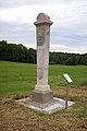
Half-mile column no. 18 near Fürstenwalde

Quarter milestone No. 19 in Fürstenwalde (replica 2012)

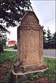
"Black Cross" at the border crossing of the Old Dresden-Teplitzer Poststrasse from Saxony to Bohemia
_Ganzmeilens%C3%A4ule_Nr._16_(10-2).jpg)
.jpg)
_2006-06-28.jpg)


See also
literature
- Jörg Brückner / Balder Preuß: On the continuation of the old Dresden-Teplitzer Poststrasse beyond the state border with Saxony. - In: Erzgebirgische Heimatblätter (1995), no. 5, pp. 6-11.
- Jörg Brückner / Balder Preuß: The Dresden-Teplitzer Poststrasse. To the course of the southern part; shown on the results of Adam Friedrich Zürner's survey trip in August 1716 through northern Bohemia. - In: Sächsische Heimatblätter 42 (1996), H. 5, pp. 308-311.
- Siegfried Lange: A ride on the Alte Dresden-Teplitzer Poststrasse. in: Sächsische Heimatblätter. Issue 6/1971. Pp. 278-281.
- Christian Preiß: The Alte Teplitzer Poststrasse. From the prehistoric climb to the highway of the 21st century. Pirna 2004 (self-published)
- Transport Museum Dresden (Ed.): Along the Old Dresden-Teplitzer Poststrasse from Dohna to the state border. Excursion guide of the Transport Museum No. 3. Dresden 1998 (leaflet)
Web links
Individual evidence
- ↑ dresdner-stadtteile.de
- ↑ Milestones for the Eastern Ore Mountains , Sächsische Zeitung (Pirna edition) of April 13, 2012
- ↑ Milestones for the Eastern Ore Mountains , Sächsische Zeitung (Pirna edition) of April 13, 2012
- ^ Columns on the old Poststrasse complete again , Sächsische Zeitung (Dippoldiswalde edition) from June 14, 2012