Maltengraben
| Maltengraben | ||
|
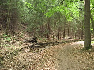
Upper course of the Maltengraben southwest of Luga |
||
| Data | ||
| Water code | DE : 53719292 | |
| location | Eastern Ore Mountains | |
| River system | Elbe | |
| Drain over | Lockwitzbach → Elbe → North Sea | |
| source | Maltegrund near Wölkau 50 ° 58 ′ 42 ″ N , 13 ° 49 ′ 14 ″ E |
|
| Source height | 180 m | |
| muzzle |
Lockwitzbach in Dresden Coordinates: 50 ° 59 '48 " N , 13 ° 50' 43" E 50 ° 59 '48 " N , 13 ° 50' 43" E |
|
| Mouth height | 114.5 m | |
| Height difference | 65.5 m | |
| Bottom slope | 15 ‰ | |
| length | 4.4 km | |
| Catchment area | 1.93 km² | |
| Drain |
MNQ MHQ HHQ (2002) |
0 l / s 200 l / s 2.9 m³ / s |
| Big cities | Dresden | |
| Medium-sized cities | Heidenau | |
The Maltengraben , also Maltegraben , is a stream in the southeast of Dresden . The Maltengraben only carries water episodically.
course
The course of the river south of the Děčín – Dresden-Neustadt railway line, designed as a high dam, is already shown in maps from the 18th century.
The Maltengraben comes from the flat and only about 1 km long valley known as Malte or Maltental . Its headwaters are near the southernmost point of Dresden on the border with Dohna , Heidenau and Kreischa, immediately northeast of the Heidenau junction on the A17 . It first flows northeast in the Lockwitz district and then crosses to Luga . The upper course in the area of the wooded Maltengrund is naturally shaped. From the end of the valley, the Maltengraben flows straight and canalized through the Elbe valley . First he crosses under Dohnaer Strasse. Due to the high elevation of the discharge profile in sections, the Maltengraben has a natural catchment area only south of Dohnaer Straße. It continues to cross state road 172 and then runs parallel to Krebser Strasse just under 100 m west of it. Then it turns 90 ° to the east at the northern end of Großluga just before Lugaer Straße and flows past allotment gardens and fields. After 1 km it reaches Heidenauer Strasse and flows around the main Dresden-Süd substation in an easterly direction. To the northwest of the Dresden- Zschachwitz S-Bahn stop , it will pass under the Děčín – Dresden-Neustadt line . From here it flows to the northeast and flows into Sporbitz at the level of the street Am Lockwitzbach in the left tributary of the same name of the Elbe . Overall, the Maltengraben is a good 4 km long.
Flood
The Maltengraben is one of the Dresden waters where floods lead to extensive flooding. During the floods in 2002 , neighboring properties, fields and the areas near the railway underpass were flooded. Even after smaller and locally limited heavy rain , residential properties in Luga were repeatedly flooded. For this reason, from the end of 2005 a retention basin costing 281,000 euros was built at the exit of the Maltental valley, and the ditch was deepened and expanded in a natural way.
The Alte Landstrasse and thus the Dresden-Teplitzer Poststrasse bridges the Maltengraben directly below this flood retention basin. Margrave Wilhelm I had this bridge destroyed in the course of the Dohna feud in 1402 so that traffic on this important route no longer runs via Dohna but via Pirna , which was only reversed a long time later.
The Maltenstrasse in Luga , the motorway slip road An der Malte in Lockwitz and the street Am Lugaer Graben in Sporbitz are named after the Maltengraben or its valley .
Web links
- State capital Dresden (publisher): Maltengraben water profile , as of February 5, 2010 (PDF; 5.6 MB)
- State capital Dresden (publisher): Maltengraben water profile , as of July 10, 2012 (online only)
Individual evidence
- ↑ a b Maltengraben water profile on www.dresden.de (PDF; 5.6 MB)
- ↑ Flood Protection - Waters of the Second Order ( Memento from October 9, 2010 in the Internet Archive ), dresden.de
- ^ Dresden themed city map , environment, flood 2002
- ↑ Page no longer available , search in web archives: dresdner-amtsblatt.de
- ↑ References from ÖkoProjekt ElbeRaum GmbH
- ^ Districts of Großluga and Kleinluga , dresden-und-sachsen.de
