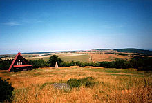
Habartice and Krupky
Habartice ( German Ebersdorf ) is a desert in the north of the Czech Republic . Its land register with an area of 1249.7746 hectares belongs to the city of Krupka .
Geographical location
Habartice is located in the north of the Czech Republic and lies between 664 (Unterdorf) and 765 m nm (Zechberg), it borders on Fürstenau and Adolfov .
history
Ebersdorf was founded in the 13th century by Franconian settlers. It is a forest hoof village . In 1363 the place was first mentioned as Eberhardsdorf. In 1392 the place was mentioned as Eberzdorf. The Church of St. Gall was built in 1783 in the Baroque style. A parsonage was built in 1800 and the school in 1845. In 1836 the Graupenbergstraße was built from Teplitz to Dresden, on the old Teplitzer Poststraße through Ebersdorf to Fürstenwalde , past the Black Cross, which was built before 1785. Furthermore, the Schenkerkreuz (748 m) and the Goldammerkreuz (724 m), both of which were built before 1785, are still on the way to the Mückentürmchen . On the way to Kulm there is a forest chapel at a height of 650 m and formerly a beech tree that lasted about 300 years. In 1938 the financial guard barracks was built southwest of the church, which should serve the training of the Hitler Youth .
In the very old linden tree next to the cemetery there was a mountain ash that is typical of the Ore Mountains. The war memorial, which is right next to the linden tree , was erected in 1922 by the choral society.
From 1945 the German population from Habartice, as Ebersdorf was now called, was expelled . After that the place was practically without inhabitants. In the 1950s, the vacant but still preserved settlement was razed to the ground with tanks.
Remnants of cellars can still be found in the area today (2016).
Development of the population
| year | population |
|---|---|
| 1869 | 1236 |
| 1880 | 1189 |
| 1890 | 992 |
| 1900 | 954 |
| 1910 | 957 |
| year | population |
|---|---|
| 1921 | 832 |
| 1930 | 771 |
| 1950 | 3 |
| 1961 | 0 |
Individual evidence
- ↑ http://www.uir.cz/katastralni-uzemi/675377/Habartice-u-Krupky
- ↑ Historický lexikon obcí České republiky - 1869-2015. Český statistický úřad, December 18, 2015, accessed on January 25, 2016 (Czech).
Coordinates: 50 ° 43 ' N , 13 ° 53' E
