
Elbe Sandstone Mountains
| Elbe Sandstone Mountains | ||
|---|---|---|
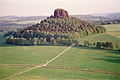
 Typical table mountain of the Elbe Sandstone Mountains: the Lilienstein |
||
| Highest peak | Děčínský Sněžník ( High Snow Mountain ) ( 722.8 m nm ) | |
| location | Border region of the Saxon Switzerland-Eastern Ore Mountains ( Saxony ) / North Bohemia ( Czech Republic ) | |
|
||
| Coordinates | 50 ° 48 ' N , 14 ° 7' E | |

The Elbe Sandstone Mountains ( Czech Labské pískovce or Labské pískovcové pohoří ) is a low mountain range built mainly from sandstone on the upper reaches of the Elbe in Saxony ( Germany ) and Northern Bohemia (Czech Republic). It is about 700 km² and reaches heights of up to 723 meters above sea level. The German part is generally referred to as Saxon Switzerland , the Czech part as Bohemian Switzerland ( České Švýcarsko ). The term "Saxon-Bohemian Switzerland" ( Českosaské Švýcarsko ), which is used more frequently today, is derived from it.
Geographical location
The Elbe Sandstone Mountains extend on both sides of the Elbe between the Czech town of Děčín ( Tetschen ) and the Saxon town of Pirna . The northern border is roughly along a line between Pirna, Hohnstein , Sebnitz , Chřibská , Česká Kamenice and Děčín. The southern boundary follows the valley of the Gottleuba from Pirna to the Ore Mountains ridge and then along the Jílovský potok ( Eulaubach ) to Děčín. The highest mountain in the mountains is the Děčínský Sněžník ( High Snow Mountain ) in the Czech part of the mountains at 723 meters , while the highest German peak is the Great Zschirnstein (561 m).
The Saxon Switzerland and Bohemian Switzerland national parks are located in the Elbe Sandstone Mountains .
General

The characteristic of this rugged rocky mountain range is its extraordinary wealth of shapes in a very small space. Unique among the Central European low mountain ranges is the ecologically significant constant alternation of plains , gorges , table mountains and rocky areas with preserved closed forest areas. The diversity of the different locations, each with their own conditions in terms of soil and microclimate , has produced an enormous variety of species . The diversity of the ferns and mosses that occur is not matched by any other German low mountain range.
The occurrence of the Elbe sandstone and thus the Elbe Sandstone Mountains is related to the large-scale deposits of a former sea in the Upper Cretaceous . On the Saxon side, one speaks of the Elbe Chalk , which extends in an area between Meißen - Oberau in the northwest via Dresden and Pirna to Saxon Switzerland and in the form of sandstones, planes and other rocks as well as older gravel at their base (basal conglomerates) Origin occurs. Some erosion relics between Reinhardtsgrimma via Dippoldiswalde and Tharandter Wald to Siebenlehn form isolated occurrences south of Dresden. They are mainly characterized by sandstones.
On the Bohemian side, the sandstone deposits continue and represent part of the North Bohemian Chalk . The chalk sediments of the Zittau Basin are assigned to the North Bohemian Chalk due to their regional geological relationships . The sediment sequences from the Chalk Sea can be traced in other regions of the Czech Republic as far as Moravia. Together these deposits form the Saxon-Bohemian Chalk Zone. In Czech geology, the Elbe Chalk is described as an extension of the Bohemian Chalk Basin .
geology

The diverse range of shapes in the sandstone landscape is a result of chemical-physical erosion and biological processes in rocks that were essentially formed from the sands deposited in the Cretaceous period .
The area of the Elbe Sandstone Mountains lies in the area of the Elbe Zone (Elbe Lineament), thus in the area of a geological fault zone between the Lusatian granite massif in the northeast and the crystalline rocks of the Ore Mountains in the southwest. The fault zone, which is several kilometers wide, runs in the Hercynian direction from southeast to northwest and has been tectonically active since the Cambrian .
A continental epoch that began in the Pennsylvania (approx. 320 mya ) and was characterized by weathering and erosion was interrupted in the Jura (approx. 180 mya ) by a brief flood. The marine sediments deposited in the process, mainly limestone , remained on the northeast edge of the Elbe zone in the area of the Lusatian thrust in the form of small clods, some of which are on the surface of the earth.
At the beginning of the Upper Cretaceous, subsidence processes began in the Cenomanium (approx. 95 mya ), which enabled a Cretaceous sea to penetrate from the west. The tributaries of the sea and marine currents transported silt , sand , gravel , gravel and plant- bearing clays over a period of approx. 8 million years into the deeper shallow sea zone . Due to diagenetic processes in different pressure regimes , sandstone layers were formed. The older deposits also included uranium-bearing clays and silts from the lower and middle cenomanium, which were mined in the Königstein uranium mine between 1963 and 1990.
In the Upper Scenomanium, a strait was formed in the area of the Elbe zone , which connected the north German-Polish sedimentary basin and the sedimentary basin in the Bohemia / Moravia region (edge basin of the Tethys Sea ). The land masses in the east of the strait formed the West Sudetian island ( Lausitzer Bergland , Jizera Mountains , Giant Mountains ). In the west, the Central European Island (Western Ore Mountains , Fichtel Mountains , Bavarian Forest ) represented the border. The sea advances of the Cenomanium thus extended far beyond the current geographical limits of the Elbe Sandstone Mountains. Sandstone deposits from this time can be found today as erosion relics u. a. in the Dippoldiswalder Heide and in the Tharandt forest ( Grillenburger sandstone ).
The sandy deposits of Turonium and Coniacium , which were determined by a multiple alternation of sea advances and sea retreats , formed the surface . This resulted in the alternating deposition of slightly weathered clayey-silty (and partly calcareous) sediments and more stable sandy-gravelly sediments. While the clayey-silty sediments often only reached thicknesses in the decimeter range, the sandy sediments reached thicknesses of up to 120 meters. The clayey-silty sediments have a water-retaining effect and thus promote weathering. These layers occur in the landscape as ledges or -Terraces, flutes , Abri ( half-cavities , the locally boof be mentioned), bedding planes and cavities (individually) as rock bridges in appearance. The sandy-gravelly sediments, on the other hand, are much more resistant, and the striking rock faces of the Elbe Sandstone Mountains are built from them.
In the Saxon area of the Elbe Sandstone Mountains, the turonium and coniacium deposits were formed with a total thickness of up to 550 meters. The most recent (and topmost) deposits can be found here. a. in the summit area of the Kleiner and Großer Winterberg (thicknesses up to 80 meters), in the uppermost layers of the Schrammstein and Affensteine (thicknesses up to 30 meters), in the summit area of the Rathener Felsrevier (including locomotive ), on the Brand and (slightly thick) as top layer of individual table mountains (including Lilienstein , Pfaffenstein ).
In the Bohemian part of the Elbe Sandstone Mountains, sedimentation took place right into the Santonium and also reached thicknesses of up to 600 meters. The youngest (and uppermost) layers of the sediment park weathered more strongly than in Saxon Switzerland, so that only layers as far as the Oberturonian remained. Only in the area of the Prebischtor (Pravčická brána) and wing wall (Křídelní stěna) do the layers of the Coniacium from the area of the Great Winterberg also extend into Bohemian Switzerland.
In the coniacium there were uplift processes again, which caused the chalk sea to run off and thus an end to sedimentation. What remained was the sea floor in the form of a layered but still undivided sandstone slab.
The stratification of the Elbe sandstone, which was first fully described by Friedrich Lamprecht , is characterized by changing horizontal structural differences (inclusions of clay minerals, grain sizes of quartz, differences in the grain binding) as well as a typical but predominantly low fossil record and more or less water-bearing layers. The individual layers were named by Lamprecht with the letters "a" to "e" (from the lying to the hanging wall ) for the stable sandy-gravelly sediments and with the Greek letters "α" to "δ" for the fine-grained and slightly weathered clayey - silty sediments. However, this classification can only be transferred to the Bohemian part of the Elbe Sandstone Mountains to a limited extent, as the stratum boundaries are not distinct and consistently pronounced, especially in the right-Elbe part. In contrast to Saxon Switzerland, the sediments here are more vertically mixed in terms of their grain size , which points to the once strongly changing ocean currents in the Chalk Sea.

The view from the Winterstein clearly shows the layered sediments.

When looking at the Affensteine , the multi-level structure is clearly recognizable: the sandstone wall of level d rises above a wall base covered with rubble, in the upper third a partly wooded terrace marks the intermediate level δ2 with the promenade, above that the sandstone wall of level e rises.
The view of the Zirkelstein shows the already heavily eroded rock crown of level d, which sits on a rubble dump of level c.

The Polenz cut deeply into the sandstone layers e to b (valley floor) at the Waltersdorfer Mühle.

At Schmilka, the Elbe valley cut extends into the a1 sandstone layer, above which rises to the right of the Elbe with the Schrammstein stones up to level e (Hoher and Mittlerer Torstein).


The regression of the Cretaceous Sea was followed almost at the same time by an uplift of the Lusatian granite massif in a south-south-west direction , which partially pushed over the chalk sandstone slab from the north and north-east and pushed it down until it broke. The fracture zone on the north and north-east border of the Elbe Sandstone Mountains is known as the Lusatian Fault (also known as the Lusatian Thrust). It runs roughly along a line from Pillnitz via Hohnstein and Hinterhermsdorf in the direction of Krásná Lípa (Schönlinde). In Hohnstein, on the western slope of the Polenz valley, on the so-called Wartenbergstrasse, there is the only geological outcrop where the location of the Lausitz granite above the chalk sandstone is directly visible.
When the granite rocks were pushed onto the chalk sandstone slab along the Lusatian Fault, the sandstone layers were partially erected and inclined. This is particularly striking at the Hohe Liebe , which was given a pointed summit shape by the collapse of the sandstone layers by up to 30 ° in a south-southeast direction and thus clearly stands out from the table mountain relief of the other sandstone mountains of the Elbe Sandstone Mountains. To the west of the Vlčí hora (Wolfsberg), the originally horizontal sandstone layers even tipped over .
At the same time, older rocks from Permian, Jurassic, Cenomanian and Turonian were dragged up along the Lusatian Fault and came to the surface. The limestone deposits from the Jura, which were mined variously in the past, gained economic importance. a. near Zeschnig and Saupsdorf , near the Obermühle Hinterhermsdorf and northeast of Doubice (Daubitz).
In the Tertiary , the adjacent area of the Central Bohemian Uplands and the Lusatian Mountains was shaped and influenced by intense volcanism, but individual magma intrusions also penetrated the sandstone slab of the Elbe Sandstone Mountains. The most striking evidence of this geological phase are above all the basaltic cone mountains Růžovský vrch ( Rosenberg ), Cottaer Spitzberg and Raumberg , but also the Großer and Kleiner Winterberg .
On the south-western edge, the sandstone slab at the Karsdorf fault was raised by more than 200 meters, causing the slab to tilt even more and the gradient of the Elbe river to increase. The water masses with their riverbed dug valleys into the rock and in places contributed to the formation of the rock walls. Over time the gradient decreased; the river bed of the Elbe stream widened and changed its course again and again, also due to ice age climatic influences.

The mineral composition of the sandstone deposits has a direct impact on the morphology of the site. The fine-grained type with a clayey-silty bond between the quartz grains causes embankments and slopes with terracing. The pebbly bound sandstone banks are typical for the formation of walls and cliffs. Slight fluctuations in the composition of the binding agent in the rock can have a visible effect on the landscape.
The Elbe sandstone owes its characteristic cuboid appearance to extensive horizontal stratification ( banks ) and vertical fissures . Bernhard Cotta wrote in his explanations on the geognostic map in 1839 : "Vertical fissures and crevices cut through, at a fairly right angle, the horizontal layers, and this creates that separation into parallelepipedic bodies that gave rise to the name cuboid sandstone."
The term ashlar sandstone mountains is a historical geological term for comparable sandstone deposits, but was also used in connection with the Elbe sandstone mountains.
The fissures were formed by long-lasting tectonic stresses on the entire sandstone plate of the mountains. This fissure network runs through these sandstone deposits in a relatively regular form in two areas of the mountain range with different directions. Subsequent weathering processes of very different types and mutual complex overlays (leaching, frost and salt blasting , wind , dissolution processes with sintering as well as biogenic and microbial effects) have further shaped the rock surfaces. For example collapse caves, small hole-like depressions ( alveoli ) with hourglasses , chimneys , crevices and rugged, mighty walls were created.
Diverse morphological formations in the rocky landscape of the Elbe Sandstone Mountains are discussed with regard to their formation as a result of karstification . Particularly frequent furrows with parallel ridges, they look like cart structures , as well as extensive cave systems in the polygenetic and polymorphic erosion landscape of the Elbe Sandstone Mountains offer important clues. They are sometimes referred to by the term pseudokarst . The transfer of the term to some forms of erosion in the sandstone of the Elbe Sandstone Mountains and the method of explanation derived from it are, however, controversial. Czech geologists state that quartzite-bound sandstone areas in the northern part of the Bohemian Chalk Basin have karst phenomena in the form of spherical cavities and cave formations. According to this, they were created by the process of dissolving water in a complex interaction with iron compounds from neighboring or intruded igneous-volcanic rocks. On the basis of these processes, the variety of the relief in those sandstone areas is explained. The Elbe Sandstone Mountains are the largest chalk sandstone erosion complex in Europe.
The anthropogenic changes caused by the sandstone mining, which continued for around 1000 years, also contributed to the shaping of the landscape that exists today in parts of the Elbe Sandstone Mountains. The fissures ( called loose by the stone crushers ) played an important role here, as they provided a natural boundary for the felling of the wall and the preparation of the raw block.
natural reserve

Large parts of the Elbe Sandstone Mountains are protected by law. In Germany there is the national park region Saxon Switzerland, which consists of the two-part 93.5 km² National Park Saxon Switzerland (NLP) founded in 1990 and the surrounding 287 km² landscape protection area (LSG) founded in 1956 . The German part of the mountains was also rated in May 2006 by the Academy of Geosciences in Hanover as one of the 77 most important national geotopes in Germany.
In the north-eastern part of the Bohemian mountains there has been a protected landscape area "Chráněná krajinná oblast Labské pískovce" (Elbe Sandstone Protected Landscape Area ) with an area of 324 km² since 1972 . In 2000 the “Národní park České Švýcarsko” (Bohemian Switzerland National Park) was established with an area of 79 km², so that around 700 km² of the total area of the mountains is protected as a natural and cultural landscape.
tourism
See also
Web links
Individual evidence
- ^ Karl Mannsfeld , Olaf Bastian: Saxon landscapes. Between Düben Heath and Zittau Mountains. Ed .: Sächsische Landesstiftung Natur und Umwelt, Naturschutzfonds. Edition Leipzig, Leipzig 2012, ISBN 978-3-361-00678-2 , p. 290.
- ↑ Königstein area, Saxon Switzerland (= values of the German homeland . Volume 1). 1st edition. Akademie Verlag, Berlin 1957. (2nd edition 1985, Appendix A) as well as Between Sebnitz, Hinterhermsdorf and the Zschirnsteinen (= values of the German homeland . Volume 2). 1st edition. Akademie Verlag, Berlin 1959. (Annex A).
- ^ A b Klaus Thalheim: On the geology of Bohemian Switzerland. In: Peter Rölke (Ed.): Hiking and nature guide Bohemian Switzerland. Berg- und Naturverlag Rölke, Dresden 2005, pp. 15–25.
- ^ Friedrich Lamprecht : The layer storage of the Turon in the Saxon-Bohemian Elbe Sandstone Mountains. In: Reports of the mathematical-physical class of the Saxon Academy of Sciences in Leipzig. 86, 1934, pp. 155-186.
- ↑ The Zeschnig lime mine. In: openmapweb.org, accessed January 5, 2014.
- ^ Vápenný vrch (Kalkofenberg) from Doubice (Daubitz). In: luzicke-hory.cz, accessed on January 5, 2014.
- ↑ W. Pälchen (ed.) / H. Walter (ed.): Geology of Saxony. Geological structure and history of development. Schweizerbart'sche Verlagsbuchhandlung, Stuttgart 2008, pp. 340–341, ISBN 978-3-510-65239-6 .
- ↑ Bernhard Cotta: Explanations on Section VI of the geognostic chart of the Kingdom of Saxony and the adjacent federal states, or: Geognostic sketch of the area between Neustadt, Bischoffswerda, Wittichenau, Rothenburg, Görlitz, Ostritz, Rumburg and Schluckenau. Arnoldische Buchhandlung, Dresden and Leipzig 1839, pp. 49–50.
- ^ Thaddäus Eduard Gumprecht: Contributions to the geognostic knowledge of some parts of Saxony and Bohemia. Siegfried Mittler, Berlin 1835 ( digitized at Archive.org ).
- ↑ Hanns Bruno Geinitz : The Quader Mountains or the chalk formation in Saxony, with special consideration of the layers rich in glauconite. Princely Jablonowski Society in Leipzig, 1850 ( digitized ).
- ^ Note on February 10, 1850 from Bernhard Cotta. In: KC von Leonhard, HG Bronn (Hrsg.): New year book for mineralogy, geognosy, geology and petrefacts customer. Stuttgart, Jg. 1850, p. 190 ( digitized from Archive.org).
- ↑ Hans Prescher : Geology of the Elbe Sandstone Mountains. Verlag Theodor Steinkopff, Dresden / Leipzig 1959, pp. 107–111.
- ^ Robert AL Wray: Quartzite dissolution: karst or pseudokarst? (PDF; 89 kB) (No longer available online.) In: speleogenesis.com. Formerly in the original ; accessed on October 26, 2018 (English, no mementos; in: Speleogenesis Journal. Vol. 1, 2003, Edition 2: Speleogenesis and Evolution of Karst Aquifers ). ( Page no longer available , search in web archives ) .
- ^ Manfred Stephan: The landscape forms - developed under other than today's conditions. Breaking up the Elbe Sandstone Mountains into rock towers - briefly? Review by: Detlef Busche, Jürgen Kempf, Ingrid Stengel: Landscapes of the Earth.
- ↑ Luc Willems: Phénomènes karstiques en roches silicatées non carbonatées: cas des grès, des micaschistes, des gneiss et des granites en Afrique sahélienne et equatoriale. Dissertation at the University of Liege. 2000 (Comprehensive discussion of sandstone karst and terminological questions in this context) ( PDF; 316 kB ).
- ↑ Luc Willems: Dissertation (complete version). Université de Liege, July 6, 2000.
- ^ Roland H. Winkelhöfer: Karst in the Elbe Sandstone Mountains. (No longer available online.) In: geoberg.de. June 12, 2010, archived from the original on October 15, 2013 (private website of Lutz Geißler): "This text appeared on the old version of geoberg.de on November 23, 2006 and was adopted."
- ↑ Jiří Adamovič: Sandstone cementation and its geomorphic and hydraulic implications. ( Memento of August 27, 2011 in the Internet Archive ) In: Ferrantia. No. 44, 2005 (Musée national d'histoire naturelle, Luxembourg) p. 22 (PDF, English; 726 kB).
- ↑ Zuzana Vařilová: České Švýcarsko. In: J. Adamovič, V. Cílek (eds.): Železivce české křídové pánve. Ironstones of the Bohemian Cretaceous Basin. Knihovna ČSS 38, Praha 2002, pp. 146–151 ( PDF; 6.4 MB ; from PDF-p. 37; Czech).
- ↑ Frank Hübner et al: Analysis of the potential for inclusion of parts of Saxon-Bohemian Switzerland as a UNESCO World Heritage Site; Part geology / geomorphology. ( Memento from December 2, 2013 in the Internet Archive ). P. 47. In: nationalparkfreunde.info. January 31, 2006, accessed on October 26, 2018 (PDF; 6.7 MB).
- ↑ Dieter Kutschke: Quarries and stone crushers in Saxon Switzerland (= series of publications by the Pirna City Museum. Issue 11). Stadtmuseum Pirna , Pirna 2000, pp. 4–5, 32.