
Cotta Spitzberg
| Cotta Spitzberg | ||
|---|---|---|
.jpg) View from the southwest of the Cotta Spitzberg |
||
| height | 390.8 m above sea level HN | |
| location | Free State of Saxony , Germany | |
| Mountains | Saxon Switzerland | |
| Coordinates | 50 ° 53 '56 " N , 13 ° 58' 12" E | |
|
||
| Type | Kegelberg | |
| rock | Trachyte - basalt | |

The Cottaer Spitzberg is a 390.8 m high basalt dome on the western edge of Saxon Switzerland . Because of its geological and botanical peculiarities, the mountain has been under nature protection as a natural monument since 1979 .
Location and surroundings
_Oberreit_1821.jpg)
The mountain, formerly also called Cottaer Spitze , is located on the plateau between the valleys of the Gottleuba in the east and the bier in the west. It towers over the village of Cotta, which is directly at its northern foot, and the surrounding area by at least 70 meters and appears as a clear landmark in the landscape.
geology
_2006-07-02.jpg)
The Cottaer Spitzberg was created during the tertiary breakthrough of basalt through the Cretaceous sandstone sediments of the Elbe Sandstone Mountains . In an environment largely shaped by sandstone , granite and gneiss , the mountain is a geological specialty.
Here it joins a series of volcanic hardened peaks, of which the Stolpener Burgberg , Wilisch and Geising are the best known. On the rocky summit of the Spitzberg, the gray-black columns of the trachyte basalt are exposed. With a thickness of about 30 cm, they tower almost vertically and were intensively removed by a quarry in the 19th century. A remnant piece of the summit was preserved because a triangulation column for Central European degree measurement or Saxon land surveying was erected on it in 1865 .
Botanical peculiarities

The Cotta Spitzberg is also significant in terms of plant geography. However, the quarry operation has limited the diversity of the local flora. Species such as the sword-leaved forest bird , the carnation or the bristle bellflower are among the species that used to occur but are no longer present today. Nevertheless, the Spitzberg still a botanically interesting habitat is. Located on the north side of an oak-hornbeam forest (including small-leaved linden , Norway maple , sycamore , ash ) interspersed with species such as the lungwort . In addition, the sun-exposed mountain is also a habitat for some heat-loving species such as the red pea and the silver cinquefoil .
history
.jpg)

In 1865 a triangulation column was built on the Cotta Spitzberg for the Saxon land survey . In the early 1960s, at the height of the Cold War , a small bunker was built on the east side of the mountain . This is where the regional leadership of the Pirna district should take refuge in the event of an atomic bomb attack on Dresden . An observation point was set up on the west side facing Dresden.
view
The Cottaer Spitzberg has always been a popular excursion destination, as the basalt summit, which is unforested at the top, offers a comprehensive all-round view, which is only partially restricted in the immediate vicinity. If the conditions are good, you can look in the direction
- North: via Pirna to the Lausitzer Bergland ,
- Northwest: over the Elbe valley ,
- West and South: across the Elbe Valley Slate Mountains to the ridge of the Eastern Ore Mountains ,
- East: over the Gottleubatal to the table mountains of Saxon Switzerland and the volcanic cones of the Bohemian Central Mountains .
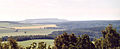
View to the southeast ( Hoher Schneeberg )
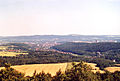
View to the north ( Pirna and Elbe Valley )

View to the west ( Cotta and foothills of the Osterzgebirge )

Foresight
_2006-07-02.jpg)
_2006-07-02.jpg)

literature
- Pirna and its surroundings (= values of the German homeland . Volume 9). 1st edition. Akademie Verlag, Berlin 1966.
- Peter Rölke (Ed.): On the edge of Saxon Switzerland. Series hiking & nature guides Saxon Switzerland Volume 3. Dresden 2004.