
Vlčí hora
| Vlčí hora | ||
|---|---|---|
 Vlčí hora from the north, view from Panský |
||
| height | 580.6 m nm | |
| location | Czech Republic | |
| Mountains | Bohemian Switzerland | |
| Coordinates | 50 ° 56 '23 " N , 14 ° 27' 55" E | |
|
||
| Type | Kegelberg | |
| rock | Granite with basalt breakthrough | |

The Vlčí hora (German Wolfsberg , 581 m) is one of the most striking mountains in the Bohemian Netherlands ( Šluknovsko ) in the Czech Republic .
Location and surroundings
The Vlčí hora is located in the Bohemian Netherlands six kilometers west of Rumburk, right on the edge of the rocky forest landscape in Bohemian Switzerland . Are the church directly at the foot Stare Křečany ( Alt Ehrenberg ) with the district Brtníky ( Zeidler ) and to Krasna Lipa ( Schönlinde related) districts Sněžná ( Schnauhübel ), Vlčí Hora ( Wolf Mountain ), Zahrady ( gardens ). A former mountain hut with an observation tower crowns the summit. At the eastern foot of the mountain is the Veronica fountain (Verunčina studánka). Immediately north of the mountain lies the headwaters of the Mandau .
history
The mountain hut on the summit was built in 1887 by the Mountain Association for northernmost Bohemia . In order to transport the building material upwards, every hiker was asked to take one brick each to the summit. In 1888 the hut was supplemented by the stone lookout tower that still exists today. The once simple log house was later expanded into a stately building with a surrounding veranda. In 1904 the building was named Ferdinand Michel House .
In contrast to all other mining areas in northernmost Bohemia, the hut survived the war and the post-war years. After 1945 the building was initially empty. From 1952 to 1957 it was used by the Czechoslovak Army. The building has been privately owned since 1972.
The observation tower was extensively repaired between 1996 and 1999 with funds from the City of Krásná Lípa and sponsorship funds and is now open to the public again. Since January 1999, the town of Krásná Lípa has owned the observation tower.
geology
The Vlčí hora is located about one kilometer northeast of the Lusatian Fault in the Lusatian granite area . The dome is made of a nepheline - feldspar basalt formed, which due to its high magnetite a strong deviation of the compass needle caused.
view

A very comprehensive panoramic view is possible from the tower. In the southwest, the view sweeps over the mountains of Saxon-Bohemian Switzerland to Milešovka ( Milleschauer ) in the Bohemian Central Uplands . In the south there is the jagged chain of cone mountains of the Lausitz Mountains with Studenec ( Kaltenberg ), Jedlová ( Tannenberg ), Lausche and Hochwald . In the east you can see the mountains of the Jizera , Jeschken and Giant Mountains . There are striking the slender Ještěd ( ridge ) with its extraordinary Tower and the wide there stored Smrk ( Tafelfichte ). In the far east you can see Szrenica ( frost carrier ) and Vysoké Kolo ( high wheel ) on a clear day. In the north are the ridges of the Lusatian mountains in Saxony with Kottmar and Valtenberg .
Paths to the summit
- A good starting point is the Panský station on the former North Bohemian industrial railway . The summit of the mountain can be reached in about 20 minutes via a yellow hiking route.
- Possible starting points are also the places Brtniky and Vlčí Hora. From there a red marked hiking trail leads to the foot of the mountain, over the above. yellow marked route the summit can be reached.
- The Vlčí hora is also a stop on the Köglerova naučná stezka ( Kögler's Nature Trail ), a 23 km long nature trail through the surroundings of Krásná Lípa.
photos
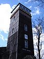
Observation tower
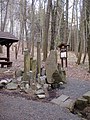
Veronica fountain


