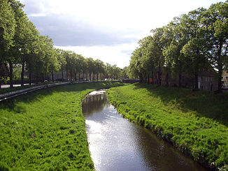
Mandau
The Mandau (Czech Mandava ) is a 40.9 km long river in the Czech Republic and Saxony .
course
It rises in several sources north of the 580.6 meter high Wolfsberg in the North Bohemian Netherlands , which is at Panský in 515 meters above sea level. Unite M. Coming from Zahrady, another spring stream flows into Nové Křečany . From there the Mandau flows in a south-easterly direction through Rumburk , Seifhennersdorf and Varnsdorf . Then it flows eastwards through another part of the Upper Lusatia, in which its water reaches among others via Großschönau , where the Lausur flows, from Hainewalde through the Roschertal to Mittelherwigsdorf , where the Landwasser flows, and finally to Zittau , where it reaches directly east of the city at 227.7 m above sea level NN flows into the Lusatian Neisse .
etymology
Mandw is known as the spelling from the 14th century . At that time there was also a Zittau district of Mandow and a porta Mandauie = Mandau gate. The name can be traced back to the Slavic mantava for cloudy water.
Water flow and consequences
The Mandau is one of the watercourses in southern Upper Lusatia, which is characterized by a very irregular flow of water. In addition, historical descriptions mention a large number of floods in the places Großschönau, Hainewalde and Zittau with damage to houses, bridges and human lives. For this reason, experts were already thinking in the middle of the 19th century about reducing the risk of flooding, at least in part, through regulations. In April 1895, work began in Zittau to create a 40 meter wide and 5.15 meter deep high river bed and dams. This resulted in a significant shortening of the course of the river by 400 meters between the Olbersdorfer Bridge and the mouth, as the Mandau previously meandered in this area. The construction costs at that time amounted to 1 million marks .
From the beginning of the 20th century, further regulations followed through expansion measures on all other sections of the Mandau, especially in the towns and on the railway lines.
Protected areas
The Mandau is partially protected both as a landscape protection area Mandautal and as an FFH area "Mandautal".
Others
According to Grosser (1714), there were “the most beautiful canvas bleaching in Zittau an der Mandau”.
Footnotes
- ↑ Hydrological Handbook. (PDF; 637 kB) Part 3 - Main aquatic values. Free State of Saxony - State Office for Environment and Geology, p. 71 , accessed on December 25, 2017 .
- ^ Christian Adolph Pescheck : Handbook of the history of Zittau. Part two . Zittau 1837, p. 433 ff . ( Google Books ).
- ^ Samuel Grosser (1714): Lusatian oddities. Leipzig and Budissin.
literature
- The south-eastern Upper Lusatia with Zittau and the Zittau Mountains (= values of the German homeland . Volume 16). 2nd Edition. Akademie Verlag, Berlin 1971.
