Goldbach (Mandau)
| Goldbach | ||
|
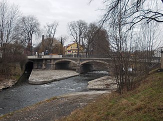
The mouth of the Goldbach (left) into the Mandau |
||
| Data | ||
| Water code | DE : 674148 | |
| location | Saxony | |
| River system | Or | |
| Drain over | Mandau → Lausitzer Neisse → Oder → Baltic Sea | |
| source | at the Dachsloch near Oybin 50 ° 50 ′ 19 ″ N , 14 ° 43 ′ 46 ″ E |
|
| Source height | 453 m above sea level NN | |
| muzzle | at the König-Albert-Brücke in Zittau in the Mandau coordinates: 50 ° 53 ′ 38 " N , 14 ° 47 ′ 55" E 50 ° 53 ′ 38 " N , 14 ° 47 ′ 55" E |
|
| Mouth height | 226 m above sea level NN | |
| Height difference | 227 m | |
| Bottom slope | 25 ‰ | |
| length | 9 km | |
| Left tributaries | Hausgrundbach, Hungerbornwasser, Natzschwasser | |
| Right tributaries | Hainbach | |
| Small towns | Zittau | |
| Communities | Oybin , Olbersdorf | |
The Goldbach is a right-hand tributary of the Mandau with a length of 9 km in its southeast Saxon estuary town of Zittau in the district of Görlitz .
description
The brook rises in the Zittau Mountains northeast of the Hainberg at Dachsloch near Oybin . In Hell, the brook reaches the bottom of the Oybiner Kessel and flows through the village of Oybin in a northeastern direction at the southern foot of the Schuppenberg and the Oybin mountain . The Goldbach breaks through the mountains between Mount Oybin, the Töpfer and the Ameisenberg . Through the gorge, in which u. a. The Teufelsmühle is located, the narrow-gauge railway Zittau – Kurort Oybin and the state road S 133 lead. After that, the Goldbach valley widens, and the houses of Niederoybin are located on the left-hand slope of the still unspoilt brook.
In the Städtel, the Goldbach reaches Olbersdorf . The houses of the Olbersdorfer Oberdorf and Niederdorf line up along its further course. The stream is developed here and set in high natural stone walls, it is crossed by numerous bridges and footbridges. The Mühlgraben and Schönmühlgraben were created to supply water to the Olbersdorfer mills. They ran through the village near the stream, but have since been thrown away again.
The lower course of the Goldbach leads east past the Olbersdorfer See . In the course of the flooding of the open pit, a ditch was dug below the Kirchberg view in Olbersdorfer Niederdorf to discharge water from the Goldbach. In the meantime the brook is no longer connected to the Olbersdorfer See. At the city limits of Zittau , the brook used to feed the ponds of the Gustav Waentig company. In the Zittauer Vorstadt, its course was built over at the beginning of the 20th century along the factory building of the Schubert weaving mill. The canalized Goldbach flows underground for a length of approx. 600 m next to the Äußere Oybiner Straße and reappears under the König-Albert-Brücke in Zittau at its confluence with the Mandau .
Flood
On August 7, 2010, heavy precipitation flooded buildings and properties, and retaining walls and bridges were also damaged.
Individual evidence
- ↑ Karen Kobelt's master's thesis "Vulnerability of rivers - analysis and assessment of the landscape with regard to the input of substances using the example of the catchment area of the Lusatian Neisse" ( Memento of the original from August 24, 2016 in the Internet Archive ) Info: The archive link was automatically inserted and not yet checked. Please check the original and archive link according to the instructions and then remove this notice. P. 30
- ↑ LMBV: After the coal comes the water ( memento of the original from August 24, 2016 in the Internet Archive ) Info: The archive link has been inserted automatically and has not yet been checked. Please check the original and archive link according to the instructions and then remove this notice. P. 17
- ↑ Several repairs to the flood in Olbersdorf in 2010 are funded by the Free State

