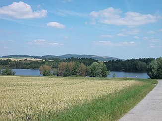
Grundbach (Mandau)
| Grundbach | ||
|
Grundbachsee |
||
| Data | ||
| location | Saxony | |
| River system | Or | |
| Drain over | Mandau → Lausitzer Neisse → Oder → Baltic Sea | |
| source | southwest of the Jonsberg 50 ° 50 ′ 29 ″ N , 14 ° 42 ′ 20 ″ E |
|
| Source height | 503 m above sea level NN | |
| muzzle | near Olbersdorf opposite the Westpark in the Mandau coordinates: 50 ° 53 '42 " N , 14 ° 46' 56" E 50 ° 53 '42 " N , 14 ° 46' 56" E |
|
| Mouth height | 231 m | |
| Height difference | 272 m | |
| Bottom slope | 24 ‰ | |
| length | 11.3 km | |
| Flowing lakes | Grundbachsee, Olbersdorfer See | |
| Communities | Jonsdorf , Olbersdorf | |
The Grundbach is an 11.3 km long right-hand tributary of the lower Mandau opposite the urban area of Zittau in the district of Görlitz in southeast Saxony .
description
The brook rises in the Zittau Mountains southwest of the Jonsberg at the Kroatzbeerwinkel near the road from Jonsdorf to Schanzendorf (Valy). Its near-natural, meadow-lined upper course runs east of the millstone quarries, past Alt-Jonsdorf with the Jonsdorf spa park and through Hänischmühe ; The stream flows around the Jonsberg on the west and north sides. On Kiefernberg the mill race is derived on the left side, it flows into Bertsdorf in the Bert Dorfer water .
At Grundbachsee, the stream is routed east of Bertsdorf and Hörnitz on the edge of the Grundbachhöhe, the renatured spoil dump of the Olbersdorf opencast mine. After the loop on the Hörnitzer Höhe, the Grundbach flows around the former heap to the east and flows into the Olbersdorfer See on the south-west bank . The outflow of the brook from the Olbersdorfer See takes place on the north bank. After 150 m the Grundbach flows into the Mandau at the level of the Westpark opposite Pethau .
From the Zittauer Westpark, an open-cast mine trail leads over the Grundbach Bridge to the new Grundbachtal, Grundbachsee and the Grundbachhöhe (319 m above sea level) around the Olbersdorfer See.
history
Mill moat
It is not known when the mill ditch, which was created to increase the water power of the Bertsdorfer Wasser , was created. The water is drained off on the left below Hänischmühe and led between the Kiefernberg and the Grenzberg to Bertsdorf . The trench was first mentioned in 1536 on the occasion of a water dispute between the Zittau council and the Cölestins on the Oybin.
Relocations of the lower reaches
The natural stream originally ran west of Olbersdorf between the Grundberg and Drachenberg in a shallow depression to the Mandau, into which the Grundbach emptied opposite the Pethauer pond. Since the 1st half of the 20th century, the overburden has been transported through the Glückaufschacht mine near Olbersdorf over the Grundbach valley and dumped on the left side of the stream. In the years 1977–1980 the Grundbach was laid in pipes for the expansion of the opencast mine to the west. After the cessation of open-cast mining, the renovation of the Olbersdorf post- mining landscape began in 1991 . As part of the creation of a local recreational water body, the flooding of the open-cast mine hole by introducing the Grundbach and the creation of a lake outlet to the Mandau was planned. Between 1995 and 1996, the Grundbach was laid over a length of 4.4 km using a natural construction method and the Grundbachsee was created as a retention basin in the Grundbach depression. The Grundbach has been flowing into the remaining hole since October 1st, 1996. After the Olbersdorfer See had reached its reservoir level at the end of February 1999, the Grundbach flowed back into the Mandau via the newly built outlet structure. The newly designed Grundbachlauf was part of the Zittau / Olbersdorf State Horticultural Show in 1999 .
Individual evidence
- ↑ Karen Kobelt's master's thesis "Vulnerability of rivers - analysis and assessment of the landscape with regard to the input of substances using the example of the catchment area of the Lusatian Neisse" ( Memento of the original from August 24, 2016 in the Internet Archive ) Info: The archive link was automatically inserted and not yet checked. Please check the original and archive link according to the instructions and then remove this notice. P. 30
- ↑ Open pit educational trail on Lake Olbersdorf - Olbersdorf - Zittau
- ↑ http: //www.bertsdorf-hörnitz.de/cms/de/42/Natur--und-Kulturpfad/203/9._Brücke_vor_dem_oberen_Kirchberg#203
- ^ Measurement table sheet, Section Zittau, around 1900
- ^ Measurement table sheet, Section Zittau, 1941
- ↑ Timeline of the history of the opencast mine
- ↑ LMBV: Olbersdorf opencast mine (1910-1991)
