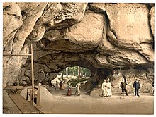
Cowshed (Saxon Switzerland)
The cowshed is the second largest rock gate in the Elbe Sandstone Mountains after the Prebischtor . It is located on the Neuer Wildenstein , a 337 m high rock in the Upper Saxon Switzerland, which was dominated by Wildenstein Castle in the 15th century . The cowshed is located south of the Lichtenhainer waterfall and above the Kirnitzschtal near Lichtenhain , but belongs to the Ostrau district and thus to Bad Schandau .
Surname
The name cowshed is attributed to two possible causes. On the one hand, during the Thirty Years' War , the population of the surrounding towns hid their cattle from marauding Swedish soldiers in the very wide rock gate . On the other hand, it is assumed that the inhabitants of the medieval castle, which in the end had degenerated into a robber baron's nest, housed the cattle there that they captured during their raids.
The first developer of Saxon Switzerland, Wilhelm Leberecht Götzinger , suggested that the Felsentor be called the Wildensteiner Felsenhalle , but this name could not prevail over the popular cowshed . From the time of the early tourist development, there are also many old inscriptions that were affixed to the walls and the ceiling of the cowshed with soot and paint or scratched into the rock.
description
There is a lookout point directly at the cowshed, secured with a railing. In the middle of the rock formation, steep stairs lead up through a narrow crevice, the so-called heavenly ladder . At the top of the stairs there is another lookout point with a panoramic view of Saxon Switzerland.
geology
The rock window lies on a clayey intermediate layer. There is smooth, polished, silicified rock on the boundary walls. The cause was the tectonic movements of the Lusatian Fault about 900 m away ; there, in the Cretaceous Period, the older granites were pushed over the younger sandstones.
The rock massif has numerous caves and overhangs that have legendary names (such as Schneiderloch and Wochenbett).
tourism
The cowshed developed into one of the main attractions in Saxon Switzerland in the early 19th century. It was an important station along the Malerweg . August von Goethe visited the rock in June 1819 and reported: “A friendly welcome with beer, strawberries, lemonade, etc. Rum also made this point a place to relax for the hungry and tired body. "
Since 1824 there has been a mountain inn next to the Felsentor, which has been rebuilt and expanded several times. With the opening of the Kirnitzschtalbahn to the Lichtenhain waterfall , the Kuhstall has been even easier to reach since 1898. From there, a wide but rather steep hiking trail leads up, which is marked with the red dot. Alternatively, you can ascend via the "old road" from the Lichtenhainer mill. The path leads past the touristically uninteresting local mountain and is marked with the yellow line.
In 1837, while on a trip , Helmina von Chézy wrote in the tourist book at the Kuhstall: “Here, where beautiful nature enchants and inspires us, bad jokes are made and pasted” and received the comment: “Eh, Mrs. von Chezy, with her verses, there she go. Ad. v. Th., July 27, 1837. "
The cowshed is still a popular destination today. From the viewing terrace south of the rock gate, the climbing rocks of the Upper Saxon Switzerland are visible in a wide panorama. Above the cowshed are the remains of the former castle, which can be reached via the narrow sky ladder.
The cowshed is part of the Malerweg on its 4th stage.
Around the rock gate there are still some rocks that invite you to hike and climb. This is how the Schneiderloch, the Blasketurm and the midwife can be explored. A small circular path with small, harmless climbing units leads around the Blasketurm. The midwife is a popular climbing rock in Saxon Switzerland.
Trivia
The cowshed is one of the most common motifs on Bohemian glass , along with other images of Saxon Switzerland.
Individual evidence
- ↑ Gotthold Sobe: August von Goethe's journey in 1819 to Saxon Switzerland . in: Sächsische Heimatblätter 16 (1970) 1, p. 43
- ↑ Moritz Gottlieb Saphir (Hrsg.): Conversations-Lexikon für Geist, Jitz und Humor. Dresden 1952, vol. 1., p. 280.
- ↑ 4th stage - hiking trail Malerweg Elbe Sandstone Mountains, Saxon Switzerland. From Altendorf to Neumannmühle. Retrieved on July 18, 2020 : "From the Lichtenhain waterfall you hike to the imposing Kuhstall rock cave on the Neuer Wildenstein."
- ↑ Climbing in Saxon Switzerland (Elbe Sandstone Mountains). Retrieved July 18, 2020 .
Web links
Coordinates: 50 ° 55 ′ 33.6 " N , 14 ° 15 ′ 23.8" E


