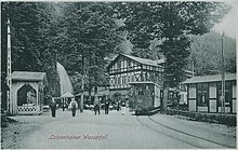
Lichtenhain waterfall

The Lichtenhain waterfall is a redesigned waterfall of the Lichtenhain village stream over sandstone cliffs shortly before the confluence with the Kirnitzsch . It is located south of the Lichtenhain district of Sebnitz in Saxon Switzerland .
history
First mention
Wilhelm Leberecht Götzinger , chronicler of Saxon Switzerland, mentioned the waterfall as early as 1812 in his work Schandau and its surroundings .
development
The originally natural small waterfall of the Lichtenhainer Dorfbach in a ravine-like notch between sandstone cliffs above the Kirnitzschtal was raised somewhat in 1830 to increase its tourist attractiveness via a short slope canal and, on the other hand, staged by a retractable weir with a surge-like runoff. The leasable office of "waterfall puller" was assigned to a Lichtenhain citizen. He had a bar and opened the dam for a few minutes for tourists . The half-timbered restaurant building dates from 1852.
From this station - in contrast to the neighboring Bytom Falls to the west, called the Great Waterfall - it was possible to hire pack animal guides, chair carriers and hiking guides to various destinations in Saxon Switzerland in the 19th century. The historical advertising sign with prices for the tax - depending on the distance between 2 and 5 marks - is still attached to the wooden "waterfall house" today.
The Lichtenhain waterfall was one of the main attractions of historical tourism in Saxon Switzerland. Hundreds of thousands of tourists have come there, especially since the Kirnitzschtalbahn was opened in 1898. In 1994 the historic dam was restored; Since then, the weir has been pulled every half hour as before. With musical accompaniment, the "waterfall puller" lets the water come slowly and, in the final chord, the masses of water pour down the rock like a torrent.
Destinations in the area
Today much used hiking trails run from the starting point Lichtenhainer Wasserfall (parking lot and terminus of the Kirnitzschtalbahn) to the destinations that were previously accessible by horse and donkey:
- Cowshed , 30 minutes;
- Historical Flößersteig educational trail (15 km);
- The painter's path , taken by artists from several generations from Caspar David Friedrich to Otto Dix ;
- Saxon Switzerland climbing area with Affensteinen , Frienstein , Kleiner Winterberg ;
- Great winter mountain .
Other weirs built for tourism in the Elbe Sandstone Mountains are also located at the Amselfall and a waterfall in the Edmundsklamm .
Card with explanations
- Compass hiking and biking map Saxon Switzerland / Western Upper Lusatia, 1: 50,000, ISBN 3-85491-633-7
literature
- Andreas Laube: The construction of the traffic routes and the transport of travelers in the Kirnitzschtal from Schandau to the Great Waterfall. In: Petra Binder (Ed.): On roads, rails and paths. Country calendar book 2011 for Saxon Switzerland and the Eastern Ore Mountains. Schütze-Engler-Weber-Verlag, Dresden 2010, pp. 130-138, ISBN 978-3-936203-14-1
Web links
Coordinates: 50 ° 55 ′ 45 ″ N , 14 ° 14 ′ 36 ″ E


